METAR & TAF KEHA
Current METAR
Observed 13:15Z
KEHA 271315Z AUTO 21012G18KT 10SM CLR 28/12 A3000 RMK AO2 T02800122
- Wind
- 210° @ 12G18 kt
- Visibility
- 10 SM
- Temp / Dew
- 28°C / 12°C
- Altimeter
- 30.00 inHg
- Clouds
- CLR
- Density alt
- 5,952 ft
- Ceiling
- Unlimited
- Rules
- VFR
Airport info & contacts
Manager on record, flight service, ARTCC, attendance schedule and pattern altitude — published by the FAA and refreshed every 28 days.
Location
- From city
- 1 NM E
- VFR sectional
- WICHITA
- ARTCC
- ZKC · KANSAS CITY
- NOTAM facility
- ICT (NOTAM-D)
Airport manager
- Name
- DENNIS TEVEBAUGH
- Phone
- (620) 360-6100
- Address
- PO BOX 392, ELKHART KS 67950
Flight service · Hours
- FSS ICT
- WICHITA1-800-WX-BRIEF
- Attendance
- Unattended
Frequencies
Tap any row to copy the frequency to your clipboard.
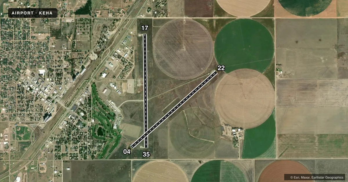
Runways & pattern
Full pagePattern entry · RWY 22
LEFT TRAFFIC| Runway | Heading (°M) | Length | Surface | Traffic |
|---|---|---|---|---|
| 17/35 | 172° / 352° | 4,907 ft | CONC | 35 R |
| 04/22Favored | 41° / 221° | 4,900 ft | ASPH | 04 R |
Runway end performance
| End | TORA | TODA | ASDA | LDA | VGSI | Approach lights | Obstruction |
|---|---|---|---|---|---|---|---|
| 17 | — | — | — | — | PAPI 4-box left(3°) | — | 18', pole, 917' from thr, 100' R of cntrln, slope 39 |
| 35 | — | — | — | — | PAPI 4-box left(3°) | — | 15', road, 506' from thr, 0' R of cntrln, slope 20 |
| 04 | — | — | — | — | PAPI 4-box left(3°) | — | 15', road, 546' from thr, 0' R of cntrln, slope 23 |
| 22 | — | — | — | — | PAPI 4-box left(3°) | — | 21', tower, 279' from thr, 0' R of cntrln, slope 3 |
Declared distances in feet. TORA = takeoff run available, TODA = takeoff distance, ASDA = accelerate-stop, LDA = landing distance.
Airport sketch
Runways drawn to scale from FAA survey coordinates, rendered over satellite imagery. Not for navigation.
Approaches & charts
Services on the field
Fuel grades, oxygen, maintenance, ramp storage and lighting — as declared to the FAA by the airport operator.
Fuel & services
- Fuel
- 100LL
- Oxygen (bottled)
- Not available
- Oxygen (bulk)
- Not available
- Other services
- AGRI,INSTR
Ramp & ground
- Transient storage
- Tie-down
- Hangar
- Landing fee
- No fee published
- Customs
- Not available
- Lighting schedule
- SEE RMK
- Beacon schedule
- SS-SR
- Beacon
- White / Green (civil land)(WG)
- Wind indicator
- Lighted
- Segmented circle
- Yes
Fuel & FBOs
Cheapest 100LL and Jet A on the field and nearby. Always confirm with the FBO before taxi.
Airport notes
Surface conditions, obstructions, local procedures, lighting outages and other notes published with each FAA cycle.
General notes
- PUBLIC PHONE (620) 697-9803.
- FOR CD CTC KANSAS CITY ARTCC AT 913-254-8508.
Lighting notes
- ACTVT PAPI RWY 04, 17, 22 & 35; MIRL RWY 04/22 & 17/35 - CTAF.
Fuel notes
- 100LLFOR FUEL CALL (620) 697-2803.
Approach & departure obstructions
- 22PIVOT IRRIGATION TWR (MOVING WHEN IN OPN).
Other notes
- MANAGERCELL PHONE # 620-360-3600.
VFR map & nearby airports
VFR sectional. Tap any ICAO chip to open that airport.
Key facts · KEHA
Answer card- ICAO
- KEHA
- Name
- ELKHART-MORTON COUNTY
- Location
- ELKHART, KANSAS
- Elevation
- 3,621.9 ft MSL
- Traffic pattern altitude
- 4,621.9 ft MSL (1,000 AGL)
- Control tower
- Non-towered (use CTAF)
- Total runways
- 2
- Longest runway
- 17/35 · 4,907 ft
- Published ILS approaches
- 0
- Published frequencies
- 2
- Magnetic variation
- 7°
- Current flight rules
- VFR
- Current wind
- 210° at 12 kt
- Favored runway now
- RWY 22
Elkhart-Morton County Airport is in Elkhart, Kansas. The field elevation is 3,621.9 ft MSL. It has two runways. The longest is runway 17/35 at 4,907 ft. Runway 04/22 is 4,900 ft. This is an untowered field, so standard CTAF self-announce procedures apply on 122.8. No ILS approaches are published here.
Pattern altitude is not published. Use the standard 1,000 ft AGL pattern for light piston traffic unless local procedures or current chart data say otherwise. The airport sits in southwest Kansas, so density altitude can be a real factor in warm weather. Plan performance with the elevation in mind. Runway lighting is medium intensity on both runways. It is controlled by CTAF. PAPI is listed on runways 04, 17, 22 and 35.
Morton County Airport is the on-field FBO. It carries 100LL. If you need fuel or current ramp details, call ahead at the number in the Chart Supplement. One published remark matters for taxi and landing on runway 22. A pivot irrigation tower can move when it is operating near that runway. Clearance delivery is handled through Kansas City ARTCC. Check the current Chart Supplement for any other operational notes before you go.