METAR & TAF K49
K49 does not publish a METAR.
Showing the nearest reporting station: KGUY (GUYMON MUNI) · 18.3 NM away. Conditions at K49 may differ.
METAR · KGUY
Observed 12:53Z
KGUY 271253Z AUTO 23009KT 10SM CLR 28/14 A2994 RMK AO2 SLP076 T02830139
- Wind
- 230° @ 9 kt
- Visibility
- 10 SM
- Temp / Dew
- 28°C / 14°C
- Altimeter
- 29.94 inHg
- Clouds
- CLR
- Density alt
- 5,836 ft
- Ceiling
- Unlimited
- Rules
- VFR
Airport info & contacts
Manager on record, flight service, ARTCC, attendance schedule and pattern altitude — published by the FAA and refreshed every 28 days.
Location
- From city
- 1 NM W
- VFR sectional
- WICHITA
- ARTCC
- ZAB · ALBUQUERQUE
- NOTAM facility
- MLC (NOTAM-D)
Airport manager
- Name
- TERRY HAGER
- Phone
- 806-753-6567
- Address
- PO BOX 588, TEXHOMA OK 73949
Flight service · Hours
- FSS MLC
- MC ALESTER1-800-WX-BRIEF
- Attendance
- Unattended
Frequencies
Tap any row to copy the frequency to your clipboard.
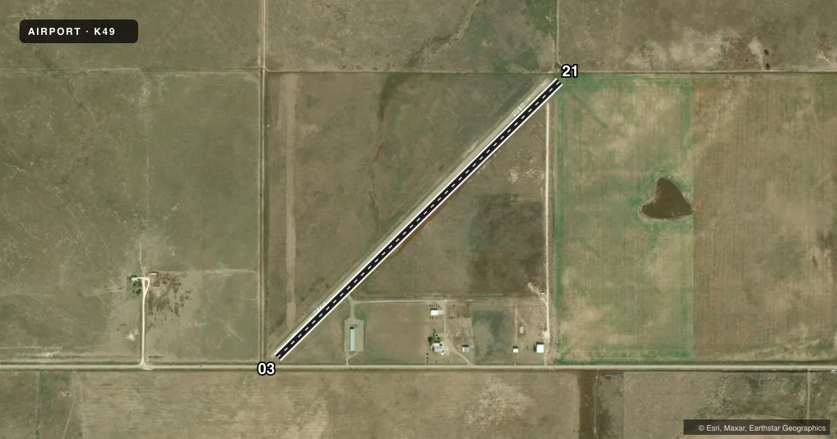
Runways & pattern
Full pagePattern entry · RWY 21
LEFT TRAFFICRunway end performance
| End | TORA | TODA | ASDA | LDA | VGSI | Approach lights | Obstruction |
|---|---|---|---|---|---|---|---|
| 03 | — | — | — | — | — | — | 15', road, 200' from thr, 75' R of cntrln, slope 0 |
| 21 | — | — | — | — | — | — | 4', fence, 200' from thr, 100' R of cntrln, slope 0 |
Declared distances in feet. TORA = takeoff run available, TODA = takeoff distance, ASDA = accelerate-stop, LDA = landing distance.
Airport sketch
Runways drawn to scale from FAA survey coordinates, rendered over satellite imagery. Not for navigation.
Approaches & charts
Services on the field
Fuel grades, oxygen, maintenance, ramp storage and lighting — as declared to the FAA by the airport operator.
Fuel & services
- Fuel
- Not available
- Oxygen (bottled)
- Not available
- Oxygen (bulk)
- Not available
- Airframe repair
- Not available
- Power plant repair
- Not available
- Other services
- AGRI
Ramp & ground
- Transient storage
- Not published
- Landing fee
- No fee published
- Wind indicator
- Yes
- Segmented circle
- No
Fuel & FBOs
Cheapest 100LL and Jet A on the field and nearby. Always confirm with the FBO before taxi.
Airport notes
Surface conditions, obstructions, local procedures, lighting outages and other notes published with each FAA cycle.
General notes
- ULTRALIGHT ACT ON & INVOF ARPT.
- WIND TURBINES 350 FT AGL LCTD 2 MI SOUTH OF ARPT.
- FOR CD CTC ALBUQUERQUE ARTCC AT 505-856-4861.
Approach & departure obstructions
- 0315 FT ROAD 0 FT FM PAVEMENT END, 115 FT RIGHT OF CNTRLN & 105 FT LEFT OF CNTRLN; 4 FT FENCE & 5 FT ROAD SIGNS 80 FT FM PAVEMENT END & 0B.
- 214 FT FENCE 0 FT FM PAVEMENT END 100 FT LEFT OF CNTRLN & 115 FT RIGHT OF CNTRLN.
- 03APCH SLOPE 35:1 TO DTHR; 15 FT ROAD 530 FT FM DTHR 155 FT LEFT OF CNTRLN.
Other notes
- MANAGERARPT BOARD CHAIRMAN.
- 17/35FAIRLY SMOOTH; FEW RODENT MOUNDS; SEVERAL PATCHES OF CACTUS.
VFR map & nearby airports
VFR sectional. Tap any ICAO chip to open that airport.
Key facts · K49
Answer card- ICAO
- K49
- Name
- TEXHOMA MUNI
- Location
- TEXHOMA, OKLAHOMA
- Elevation
- 3,468 ft MSL
- Traffic pattern altitude
- 4,468 ft MSL (1,000 AGL)
- Control tower
- Non-towered (use CTAF)
- Total runways
- 1
- Longest runway
- 03/21 · 3,564 ft
- Published ILS approaches
- 0
- Published frequencies
- 1
- Magnetic variation
- 9°
- Current flight rules
- VFR
- Current wind
- 230° at 9 kt
- Favored runway now
- RWY 21
Texhoma Muni is in Texhoma, Oklahoma. The field elevation is 3,468 ft MSL. It has one runway, 03/21, which is 3,564 ft long and asphalt. There is no control tower. CTAF is 122.9. No ILS approaches are published.
Pattern altitude is not published. Use 1,000 ft AGL for light piston traffic unless the current Chart Supplement says otherwise. That puts the traffic pattern at 4,468 ft MSL based on the field elevation. The runway is short enough that performance planning matters, especially on warm days at this elevation. Published remarks also call out obstructions near both runway ends. Runway 03 has a road, fence and road signs near the pavement edge. Runway 21 has a fence near the end of the runway. There are also wind turbines 2 miles south of the airport.
No on-field FBOs are listed. Check with the airport operator or the FBO directly by phone before arrival if you need fuel or other services. Ultralight activity is published for the airport and nearby area. Keep a sharp scan in the pattern and on final. For clearance delivery, contact Albuquerque ARTCC at 505-856-4861. If you need current noise or operating restrictions, check the current FAA Chart Supplement before flying in.