METAR & TAF E19
E19 does not publish a METAR.
Showing the nearest reporting station: KGUY (GUYMON MUNI) · 27.3 NM away. Conditions at E19 may differ.
METAR · KGUY
Observed 01:53Z
KGUY 140153Z AUTO 33007KT 10SM SCT100 BKN120 26/12 A2986 RMK AO2 PK WND 31047/0104 WSHFT 0040 LTG DSNT SE AND S RAB01E30 SLP061 P0000 T02560122
- Wind
- 330° @ 7 kt
- Visibility
- 10 SM
- Temp / Dew
- 26°C / 12°C
- Altimeter
- 29.86 inHg
- Clouds
- BKN
- Density alt
- 5,369 ft
- Ceiling
- 12,000 ft AGL
- Rules
- VFR
Airport info & contacts
Manager on record, flight service, ARTCC, attendance schedule and pattern altitude — published by the FAA and refreshed every 28 days.
Location
- From city
- 2 NM SW
- VFR sectional
- WICHITA
- ARTCC
- ZAB · ALBUQUERQUE
- NOTAM facility
- FTW (NOTAM-D)
Airport manager
- Name
- JOHNNIE WILLIAMS
- Phone
- 806-733-2424
- Address
- PO BOX 947, GRUVER TX 79040
Flight service · Hours
- FSS FTW
- FORT WORTH1-800-WX-BRIEF
- Attendance
- Unattended
Frequencies
Tap any row to copy the frequency to your clipboard.
Runways & pattern
Full pagePattern entry · RWY 02
LEFT TRAFFICRunway end performance
| End | TORA | TODA | ASDA | LDA | VGSI | Approach lights | Obstruction |
|---|---|---|---|---|---|---|---|
| 02 | — | — | — | — | — | — | 4', fence, 200' from thr, 197' R of cntrln, slope 0 |
Declared distances in feet. TORA = takeoff run available, TODA = takeoff distance, ASDA = accelerate-stop, LDA = landing distance.
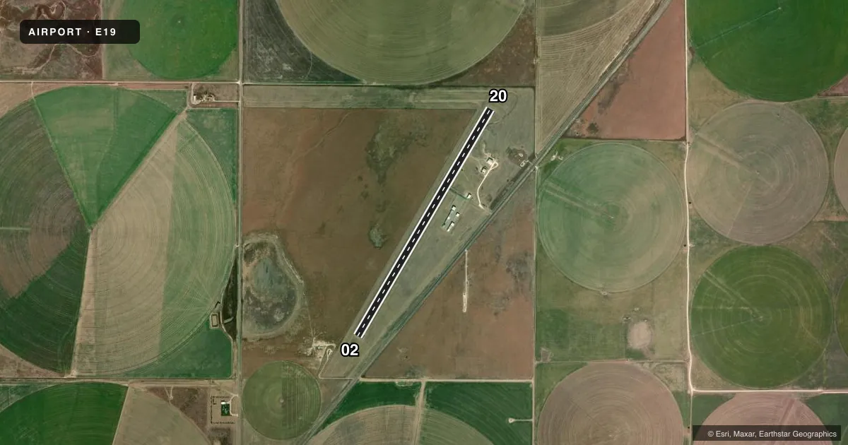
Airport sketch
Runways drawn to scale from FAA survey coordinates, rendered over satellite imagery. Not for navigation.
Approaches & charts
Services on the field
Fuel grades, oxygen, maintenance, ramp storage and lighting — as declared to the FAA by the airport operator.
Fuel & services
- Fuel
- Not available
- Oxygen (bottled)
- Not available
- Oxygen (bulk)
- Not available
- Airframe repair
- Not available
- Power plant repair
- Not available
- Other services
- AGRI
Ramp & ground
- Transient storage
- Tie-down
- Landing fee
- No fee published
- Customs
- Not available
- Lighting schedule
- SEE RMK
- Beacon schedule
- SS-SR
- Beacon
- White / Green (civil land)(WG)
- Wind indicator
- Lighted
- Segmented circle
- Yes
Fuel & FBOs
Cheapest 100LL and Jet A on the field and nearby. Always confirm with the FBO before taxi.
Airport notes
Surface conditions, obstructions, local procedures, lighting outages and other notes published with each FAA cycle.
General notes
- FOR CD CTC ALBUQUERQUE ARTCC AT 505-856-4861.
Lighting notes
- ACTVT MIRL RWY 02/20 - CTAF.
Approach & departure obstructions
- 024 FT FENCE AT THR, 200 FT LEFT.
- 02MKGS FADED.
- 20MKGS FADED.
Other notes
- THIS AIRPORT HAS BEEN SURVEYED BY THE NATIONAL GEODETIC SURVEY.
- MANAGERCITY MANAGER.
- 02/20EXTSV PAVEMENT CRACKING, POTHOLES AT RWY 20 THR.
VFR map & nearby airports
VFR sectional. Tap any ICAO chip to open that airport.
Key facts · E19
Answer card- ICAO
- E19
- Name
- GRUVER MUNI
- Location
- GRUVER, TEXAS
- Elevation
- 3,205.3 ft MSL
- Traffic pattern altitude
- 4,205.3 ft MSL (1,000 AGL)
- Control tower
- Non-towered (use CTAF)
- Total runways
- 1
- Longest runway
- 02/20 · 4,698 ft
- Published ILS approaches
- 0
- Published frequencies
- 1
- Magnetic variation
- 5°
- Current flight rules
- VFR
- Current wind
- 330° at 7 kt
- Favored runway now
- RWY 02
Gruver Muni sits in Gruver, Texas. The field elevation is 3,205.3 ft MSL. It has one runway. Runway 02/20 is 4,698 ft long with an asphalt surface. There is no control tower, so use CTAF 122.9 for self-announce traffic. No ILS approaches are published here.
Pattern altitude is not published. Use the standard 1,000 ft AGL unless the current Chart Supplement says otherwise. That puts the light aircraft pattern at about 4,205.3 ft MSL based on the field elevation. Confirm the current published procedures before you go. The runway lights on 02/20 are medium intensity. They are activated by CTAF. That helps for night ops, but you still need to verify the lighting setup before arrival.
There are no on-field FBOs listed in the facts. Contact the airport operator directly before arrival, or call the field on CTAF for current fuel and service availability. Published remarks also note pavement cracking and potholes near the threshold of runway 20. Runway 20 markings are faded. Runway 02 has faded markings too. There is also a 4-foot fence near the threshold of runway 02, about 200 feet left of centerline. The airport is surveyed by the National Geodetic Survey. For clearance delivery, contact Albuquerque ARTCC at 505-856-4861.