METAR & TAF KDUX
Current METAR
Observed 16:35Z
KDUX 271635Z AUTO 20013G18KT 10SM CLR 36/14 A3001 RMK AO2
- Wind
- 200° @ 13G18 kt
- Visibility
- 10 SM
- Temp / Dew
- 36°C / 14°C
- Altimeter
- 30.01 inHg
- Clouds
- CLR
- Density alt
- 7,004 ft
- Ceiling
- Unlimited
- Rules
- VFR
Airport info & contacts
Manager on record, flight service, ARTCC, attendance schedule and pattern altitude — published by the FAA and refreshed every 28 days.
Location
- From city
- 2 NM W
- VFR sectional
- ALBUQUERQUE
- ARTCC
- ZAB · ALBUQUERQUE
- NOTAM facility
- DUX (NOTAM-D)
Airport manager
- Name
- DON WILLINGHAM
- Phone
- 806-935-6995
- Address
- 5932 US 87, DUMAS TX 79029
Flight service · Hours
- FSS FTW
- FORT WORTH1-800-WX-BRIEF
- Attendance
- 0800-1700
Frequencies
Tap any row to copy the frequency to your clipboard.
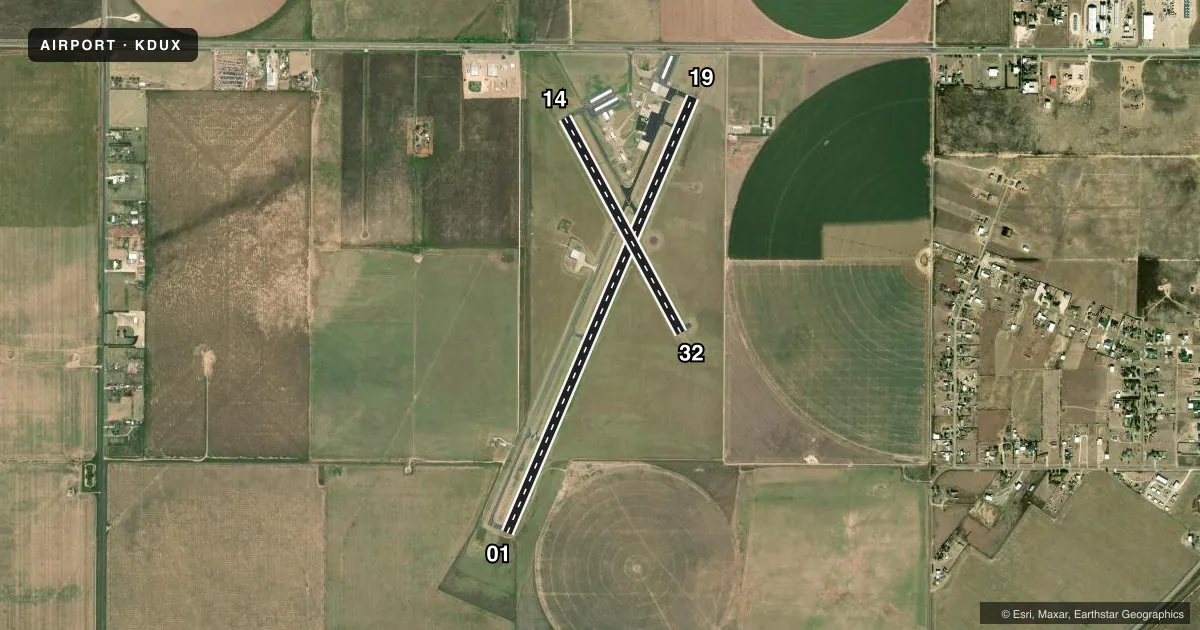
Runways & pattern
Full pagePattern entry · RWY 19
LEFT TRAFFIC| Runway | Heading (°M) | Length | Surface | Traffic |
|---|---|---|---|---|
| 01/19Favored | 14° / 194° | 6,001 ft | ASPH | Standard L |
| 14/32 | 143° / 323° | 3,100 ft | ASPH | Standard L |
Runway end performance
| End | TORA | TODA | ASDA | LDA | VGSI | Approach lights | Obstruction |
|---|---|---|---|---|---|---|---|
| 01 | — | — | — | — | PAPI 4-box left(3°) | — | — |
| 19 | — | — | — | — | PAPI 4-box left(3°) | — | 15', road, 500' from thr, 295' R of cntrln, slope 20 |
| 14 | — | — | — | — | — | — | 29', pline, 790' from thr, 190' R of cntrln, slope 20 |
Declared distances in feet. TORA = takeoff run available, TODA = takeoff distance, ASDA = accelerate-stop, LDA = landing distance.
Airport sketch
Runways drawn to scale from FAA survey coordinates, rendered over satellite imagery. Not for navigation.
Approaches & charts
Services on the field
Fuel grades, oxygen, maintenance, ramp storage and lighting — as declared to the FAA by the airport operator.
Fuel & services
- Fuel
- 100LLA
- Oxygen (bottled)
- Not available
- Oxygen (bulk)
- Not available
- Airframe repair
- Major
- Power plant repair
- Major
- Other services
- AGRI
Ramp & ground
- Transient storage
- Tie-down
- Hangar
- Landing fee
- No fee published
- Customs
- Not available
- Lighting schedule
- SEE RMK
- Beacon schedule
- SS-SR
- Beacon
- White / Green (civil land)(WG)
- Wind indicator
- Lighted
- Segmented circle
- Yes
Fuel & FBOs
Cheapest 100LL and Jet A on the field and nearby. Always confirm with the FBO before taxi.
Airport notes
Surface conditions, obstructions, local procedures, lighting outages and other notes published with each FAA cycle.
General notes
- EXTSV CROP DUSTING MAR-SEP.
- FOR CD CTC ALBUQUERQUE ARTCC AT 505-856-4861.
Lighting notes
- MIRL RWY 01/19 PRESET LOW INTST; TO INCR INTST ACTVT - CTAF. PAPI RWY 01 & 19 OPR CONSLY.
Fuel notes
- 100LL100 LL SELF-SERVE FUEL AVBL 24 HRS.
Other notes
- 1FOR SVCS AFT HRS CALL 806-935-6995.
VFR map & nearby airports
VFR sectional. Tap any ICAO chip to open that airport.
Key facts · KDUX
Answer card- ICAO
- KDUX
- Name
- MOORE COUNTY
- Location
- DUMAS, TEXAS
- Elevation
- 3,706.4 ft MSL
- Traffic pattern altitude
- 4,706.4 ft MSL (1,000 AGL)
- Control tower
- Non-towered (use CTAF)
- Total runways
- 2
- Longest runway
- 01/19 · 6,001 ft
- Published ILS approaches
- 0
- Published frequencies
- 2
- Magnetic variation
- 9°
- Current flight rules
- VFR
- Current wind
- 200° at 13 kt
- Favored runway now
- RWY 19
Moore County Airport sits in Dumas, Texas. Field elevation is 3,706.4 ft MSL. The airport has two asphalt runways. The longest is 6,001 ft on runway 01/19. Runway 14/32 is 3,100 ft. There is no control tower. CTAF and UNICOM are both 122.8.
No ILS approaches are published here. Pattern altitude is not published, so plan on the standard 1,000 ft AGL for light piston traffic unless the current FAA Chart Supplement says otherwise. The on-field FBO is Moore County Airport. It carries 100LL, Jet A and Jet A Prist. Self-serve 100LL is available 24 hours. For services after hours, call the airport at (806) 935-6995.
A few operational notes matter here. Extensive crop dusting occurs from March through September. Expect to keep a sharp scan outside the pattern during that season. Medium intensity runway lights on 01/19 are preset to low intensity. Use the CTAF to increase intensity. The PAPI on runways 01 and 19 operate continuously. For clearance delivery, contact Albuquerque ARTCC at 505-856-4861. At this elevation, performance planning matters. Density altitude can climb fast on warm Texas days. Check your takeoff and climb numbers before you go.