METAR & TAF E52
E52 does not publish a METAR.
Showing the nearest reporting station: KHRX (HEREFORD MUNI) · 22.5 NM away. Conditions at E52 may differ.
METAR · KHRX
Observed 06:35Z
KHRX 270635Z AUTO 20011G16KT 10SM 29/11 A3006 RMK AO2 T02850110 TSNO
- Wind
- 200° @ 11G16 kt
- Visibility
- 10 SM
- Temp / Dew
- 29°C / 11°C
- Altimeter
- 30.06 inHg
- Clouds
- Clear
- Density alt
- 6,460 ft
- Ceiling
- Unlimited
- Rules
- VFR
Airport info & contacts
Manager on record, flight service, ARTCC, attendance schedule and pattern altitude — published by the FAA and refreshed every 28 days.
Location
- From city
- 2 NM SE
- VFR sectional
- ALBUQUERQUE
- ARTCC
- ZAB · ALBUQUERQUE
- NOTAM facility
- FTW (NOTAM-D)
Airport manager
- Name
- JUDGE SHAWN BALLEW
- Phone
- 806-639-2145
- Address
- PO BOX 195, VEGA TX 79092
Flight service · Hours
- FSS FTW
- FORT WORTH1-800-WX-BRIEF
- Attendance
- Unattended
Frequencies
Tap any row to copy the frequency to your clipboard.
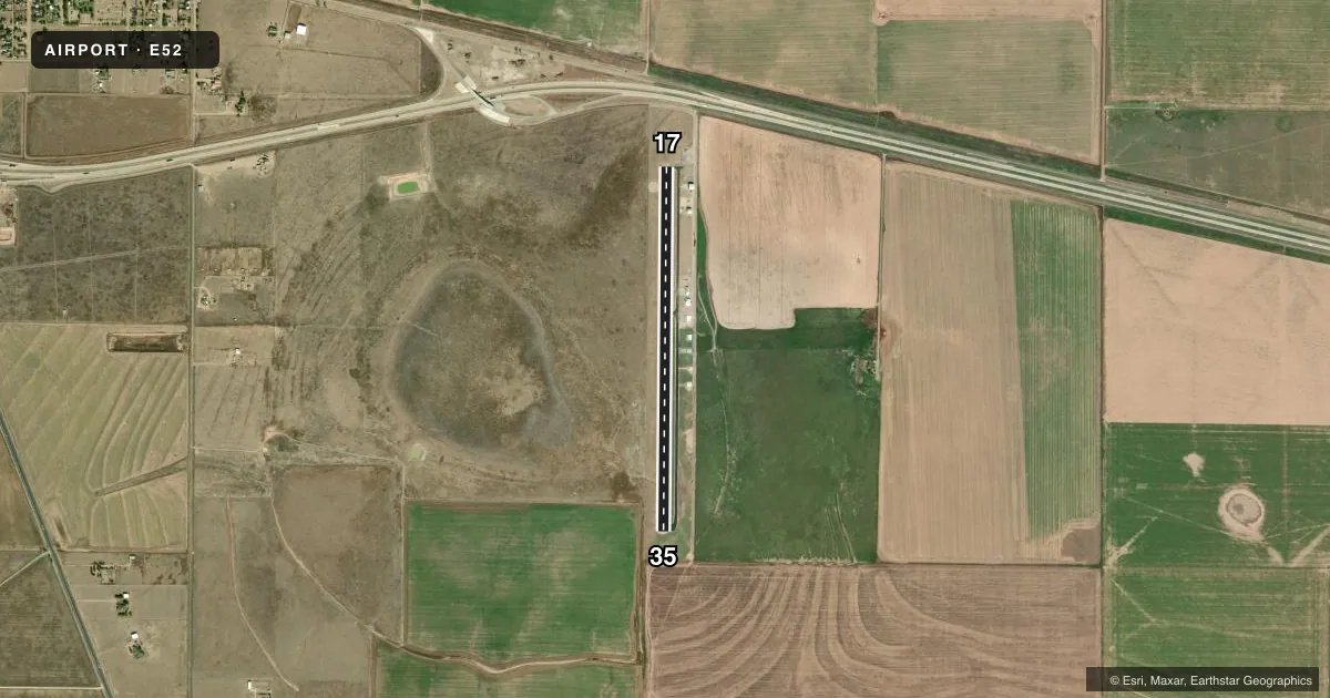
Runways & pattern
Full pagePattern entry · RWY 17
LEFT TRAFFICRunway end performance
| End | TORA | TODA | ASDA | LDA | VGSI | Approach lights | Obstruction |
|---|---|---|---|---|---|---|---|
| 17 | — | — | — | — | PAPI 2-box left | — | 32', pline, 1133' from thr, 0' R of cntrln, slope 29 |
| 35 | — | — | — | — | — | — | 4', fence, 343' from thr, 0' R of cntrln, slope 35 |
Declared distances in feet. TORA = takeoff run available, TODA = takeoff distance, ASDA = accelerate-stop, LDA = landing distance.
Airport sketch
Runways drawn to scale from FAA survey coordinates, rendered over satellite imagery. Not for navigation.
Approaches & charts
Services on the field
Fuel grades, oxygen, maintenance, ramp storage and lighting — as declared to the FAA by the airport operator.
Fuel & services
- Fuel
- 100LL
- Oxygen (bottled)
- Not available
- Oxygen (bulk)
- Not available
- Airframe repair
- Not available
- Power plant repair
- Not available
- Other services
- AGRI
Ramp & ground
- Transient storage
- Tie-down
- Landing fee
- No fee published
- Customs
- Not available
- Lighting schedule
- SEE RMK
- Beacon schedule
- SS-SR
- Beacon
- White / Green (civil land)(WG)
- Wind indicator
- Lighted
- Segmented circle
- Yes
Fuel & FBOs
Cheapest 100LL and Jet A on the field and nearby. Always confirm with the FBO before taxi.
Airport notes
Surface conditions, obstructions, local procedures, lighting outages and other notes published with each FAA cycle.
General notes
- FOR CD CTC ALBUQUERQUE ARTCC AT 505-856-4861.
Lighting notes
- ACTVT PAPI RWY 17; MIRL RWY 17/35 - CTAF.
Fuel notes
- 100LLFUEL 24 HR SELF SERVE.
Other notes
- MANAGERAMGR CELL 806-382-3883
VFR map & nearby airports
VFR sectional. Tap any ICAO chip to open that airport.
Key facts · E52
Answer card- ICAO
- E52
- Name
- OLDHAM COUNTY
- Location
- VEGA, TEXAS
- Elevation
- 3,995 ft MSL
- Traffic pattern altitude
- 4,995 ft MSL (1,000 AGL)
- Control tower
- Non-towered (use CTAF)
- Total runways
- 1
- Longest runway
- 17/35 · 4,200 ft
- Published ILS approaches
- 0
- Published frequencies
- 1
- Magnetic variation
- 9°
- Current flight rules
- VFR
- Current wind
- 200° at 11 kt
- Favored runway now
- RWY 17
Oldham County Airport sits near Vega, Texas. The field elevation is 3,995 ft MSL. It has one runway, 17/35, with a length of 4,200 ft. There is no control tower. CTAF is 122.9. No ILS approaches are published here.
Pattern altitude is not published. Use the standard 1,000 ft AGL pattern unless local procedures or current chart data say otherwise. That puts the light aircraft pattern at 4,995 ft MSL. The airport is a high-elevation field on the High Plains, so performance planning matters on warm days. Runway lighting is medium intensity on 17 and 35. It is controlled by CTAF. PAPI is active on runway 17.
Oldham County Airport is the on-field FBO. It carries 100LL. 100LL is also available 24 hours by self-service. The airport manager cell phone number is published as 806-382-3883. For clearance delivery, contact Albuquerque ARTCC at 505-856-4861. If you are planning a first stop here, check the current FAA Chart Supplement for any operational notes before departure. The runway is asphalt and the longest runway is 4,200 ft, so weight and density altitude planning are worth a close look before you launch.