METAR & TAF 1E7
1E7 does not publish a METAR.
Showing the nearest reporting station: KAMA (RICK HUSBAND AMARILLO INTL) · 12.6 NM away. Conditions at 1E7 may differ.
METAR · KAMA
Observed 18:53Z
KAMA 271853Z 15011G16KT 10SM CLR 39/12 A2999 RMK AO2 SLP083 T03890117
- Wind
- 150° @ 11G16 kt
- Visibility
- 10 SM
- Temp / Dew
- 39°C / 12°C
- Altimeter
- 29.99 inHg
- Clouds
- CLR
- Density alt
- 7,307 ft
- Ceiling
- Unlimited
- Rules
- VFR
Airport info & contacts
Manager on record, flight service, ARTCC, attendance schedule and pattern altitude — published by the FAA and refreshed every 28 days.
Location
- From city
- 9 NM S
- VFR sectional
- DALLAS-FT WORTH
- ARTCC
- ZAB · ALBUQUERQUE
- NOTAM facility
- FTW (NOTAM-D)
Airport manager
- Name
- JON KUEHLER
- Phone
- 720-412-1132
- Address
- 13990 BUFFALO AIRPORT RD, AMARILLO TX 79118
Flight service · Hours
- FSS FTW
- FORT WORTH1-800-WX-BRIEF
- Attendance
- IREG
Frequencies
Tap any row to copy the frequency to your clipboard.
Runways & pattern
Full pagePattern entry · RWY 20
RIGHT TRAFFIC| Runway | Heading (°M) | Length | Surface | Traffic |
|---|---|---|---|---|
| 02/20Favored | 14° / 194° | 6,200 ft | TURF | 20 R |
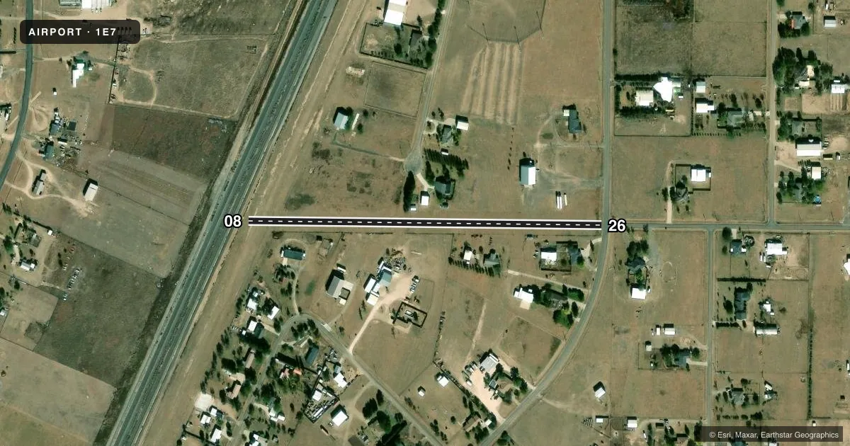
| 08/26 | 82° / 262° | 1,600 ft | TURF | Standard L |
Runway end performance
| End | TORA | TODA | ASDA | LDA | VGSI | Approach lights | Obstruction |
|---|---|---|---|---|---|---|---|
| 02 | — | — | — | — | — | — | 4', fence, 0' from thr, 0' R of cntrln, slope 0 |
| 20 | — | — | — | — | — | — | 30', tree, 250' from thr, 78' R of cntrln, slope 8 |
| 08 | — | — | — | — | — | — | 37', pline, 208' from thr, 0' R of cntrln, slope 5 |
| 26 | — | — | — | — | — | — | 15', road, 10' from thr, 0' R of cntrln, slope 0 |
Declared distances in feet. TORA = takeoff run available, TODA = takeoff distance, ASDA = accelerate-stop, LDA = landing distance.
Airport sketch
Runways drawn to scale from FAA survey coordinates, rendered over satellite imagery. Not for navigation.
Approaches & charts
Services on the field
Fuel grades, oxygen, maintenance, ramp storage and lighting — as declared to the FAA by the airport operator.
Fuel & services
- Fuel
- Not available
- Oxygen (bottled)
- Not available
- Oxygen (bulk)
- Not available
Ramp & ground
- Transient storage
- Tie-down
- Hangar
- Landing fee
- No fee published
- Customs
- Not available
- Lighting schedule
- SS-SR
- Beacon schedule
- SS-SR
- Beacon
- White / Green (civil land)(WG)
- Wind indicator
- Yes
- Segmented circle
- No
Fuel & FBOs
Cheapest 100LL and Jet A on the field and nearby. Always confirm with the FBO before taxi.
Airport notes
Surface conditions, obstructions, local procedures, lighting outages and other notes published with each FAA cycle.
General notes
- FOR CD CTC ALBUQUERQUE ARTCC AT 505-856-4861.
Runway surface & condition
- 08/26NSTD SOLAR LIRL.
Approach & departure obstructions
- 02ALSO 30 FT TREE, 100 FT DSTC.
VFR map & nearby airports
VFR sectional. Tap any ICAO chip to open that airport.
Key facts · 1E7
Answer card- ICAO
- 1E7
- Name
- BUFFALO
- Location
- AMARILLO, TEXAS
- Elevation
- 3,640 ft MSL
- Traffic pattern altitude
- 4,640 ft MSL (1,000 AGL)
- Control tower
- Non-towered (use CTAF)
- Total runways
- 2
- Longest runway
- 02/20 · 6,200 ft
- Published ILS approaches
- 0
- Published frequencies
- 2
- Magnetic variation
- 9°
- Current flight rules
- VFR
- Current wind
- 150° at 11 kt
- Favored runway now
- RWY 20
Buffalo Airport (1E7) sits near Amarillo, Texas. Field elevation is 3,640 ft MSL. The airport has two turf runways. The longest is 02/20 at 6,200 ft. Runway 08/26 is 1,600 ft. There is no control tower, so use CTAF or UNICOM 122.8 for local traffic calls.
No ILS approaches are published here. Pattern altitude is not published in the facts, so plan on the standard 1,000 ft AGL for light piston operations unless the current Chart Supplement says otherwise. The field is in a high-elevation part of Texas, so density altitude can matter a lot on warm days. That is especially true on turf.
Published remarks note nonstandard solar low-intensity lighting on runway 08/26. There is also a 30 ft tree about 100 ft from runway 02. For clearance delivery, contact Albuquerque ARTCC at 505-856-4861. No on-field FBOs are listed in the facts, so verify services with the airport operator or call the field directly before you go.