METAR & TAF 55T
55T does not publish a METAR.
Showing the nearest reporting station: KAMA (RICK HUSBAND AMARILLO INTL) · 14.5 NM away. Conditions at 55T may differ.
METAR · KAMA
Observed 17:53Z
KAMA 271753Z 20011KT 10SM CLR 38/12 A3001 RMK AO2 SLP091 T03780122 10378 20228 58008
- Wind
- 200° @ 11 kt
- Visibility
- 10 SM
- Temp / Dew
- 38°C / 12°C
- Altimeter
- 30.01 inHg
- Clouds
- CLR
- Density alt
- 6,957 ft
- Ceiling
- Unlimited
- Rules
- VFR
Airport info & contacts
Manager on record, flight service, ARTCC, attendance schedule and pattern altitude — published by the FAA and refreshed every 28 days.
Location
- From city
- 2 NM W
- VFR sectional
- DALLAS-FT WORTH
- ARTCC
- ZAB · ALBUQUERQUE
- NOTAM facility
- FTW (NOTAM-D)
Airport manager
- Name
- JUSTIN BRITTEN
- Phone
- 806-674-8993
- Address
- 300 FM 2880, GROOM TX 79039
Flight service · Hours
- FSS FTW
- FORT WORTH1-800-WX-BRIEF
- Attendance
- ALL
Frequencies
Tap any row to copy the frequency to your clipboard.
Runways & pattern
Full pagePattern entry · RWY 17
LEFT TRAFFICRunway end performance
| End | TORA | TODA | ASDA | LDA | VGSI | Approach lights | Obstruction |
|---|---|---|---|---|---|---|---|
| 17 | — | — | — | — | — | — | 4', fence, 0' from thr, 70' R of cntrln, slope 0 |
| 35 | — | — | — | — | — | — | 4', fence, 0' from thr, slope 0 |
Declared distances in feet. TORA = takeoff run available, TODA = takeoff distance, ASDA = accelerate-stop, LDA = landing distance.
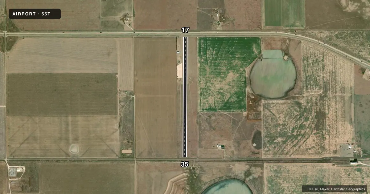
Airport sketch
Runways drawn to scale from FAA survey coordinates, rendered over satellite imagery. Not for navigation.
Approaches & charts
Services on the field
Fuel grades, oxygen, maintenance, ramp storage and lighting — as declared to the FAA by the airport operator.
Fuel & services
- Fuel
- Not available
Ramp & ground
- Transient storage
- Tie-down
- Lighting schedule
- SEE RMK
- Wind indicator
- Yes
- Segmented circle
- No
Fuel & FBOs
Cheapest 100LL and Jet A on the field and nearby. Always confirm with the FBO before taxi.
Airport notes
Surface conditions, obstructions, local procedures, lighting outages and other notes published with each FAA cycle.
General notes
- FOR CD CTC ALBUQUERQUE ARTCC AT 505-856-4861.
- WIND TURBINES INVOF ARPT.
- DEEP TIRE RUTS ACRS RWY, APRXLY 660 FT & 1700 FT FM N END.
Lighting notes
- DUSK-0100
Runway surface & condition
- 17/35NSTD LIRL; ONLY CENTER 3500 FT LGTD. LIGHTS OTS INDEFLY.
Approach & departure obstructions
- 1725 FT PLINE 300 FT DSTC.
Other notes
- 17/35RWY SFC ROUGH.
VFR map & nearby airports
VFR sectional. Tap any ICAO chip to open that airport.
Key facts · 55T
Answer card- ICAO
- 55T
- Name
- EAGLES AERODROME
- Location
- CONWAY, TEXAS
- Elevation
- 3,475 ft MSL
- Traffic pattern altitude
- 4,475 ft MSL (1,000 AGL)
- Control tower
- Non-towered (use CTAF)
- Total runways
- 1
- Longest runway
- 17/35 · 5,000 ft
- Published ILS approaches
- 0
- Published frequencies
- 2
- Magnetic variation
- 9°
- Current flight rules
- VFR
- Current wind
- 200° at 11 kt
- Favored runway now
- RWY 17
Eagles Aerodrome sits near Conway, Texas. Field elevation is 3,475 ft MSL. The airport has one runway. Runway 17/35 is 5,000 ft long and turf. The runway surface is rough. There are deep tire ruts reported across the runway about 660 ft and 1,700 ft from the north end. Wind turbines are noted in the vicinity, so plan your arrival with that in mind.
This is an untowered field. CTAF and UNICOM are both 122.8. No ILS approaches are published. Pattern altitude is not published, so verify the current traffic pattern altitude before you go. The published lighting note says the runway has nonstandard low intensity lights, with only the center 3,500 ft lighted. The lights are out of service indefinitely. A lighting schedule is listed from dusk to 0100, so confirm current status before a night arrival.
There is no on-field FBO listed. For clearance delivery, contact Albuquerque ARTCC at 505-856-4861. The field also has a 25 ft power line about 300 ft from runway 17. For a first-time visit, treat this as a rough turf strip with high elevation and limited lighting. Check the current FAA Chart Supplement and call the airport operator before you launch.