METAR & TAF 28X
28X does not publish a METAR.
Showing the nearest reporting station: KPPA (PERRY LEFORS FLD) · 9.5 NM away. Conditions at 28X may differ.
METAR · KPPA
Observed 18:50Z
KPPA 271850Z AUTO 14006G14KT 10SM CLR 41/12 A2997 RMK AO2 T04050115
- Wind
- 140° @ 6G14 kt
- Visibility
- 10 SM
- Temp / Dew
- 41°C / 12°C
- Altimeter
- 29.97 inHg
- Clouds
- CLR
- Density alt
- 7,081 ft
- Ceiling
- Unlimited
- Rules
- VFR
Airport info & contacts
Manager on record, flight service, ARTCC, attendance schedule and pattern altitude — published by the FAA and refreshed every 28 days.
Location
- From city
- 5 NM SW
- VFR sectional
- DALLAS-FT WORTH
- ARTCC
- ZAB · ALBUQUERQUE
Airport manager
- Name
- TERRY O'NEAL
- Phone
- 806-662-2582
- Address
- 8084 COUNTY ROAD 6, PAMPA TX 79065
Flight service · Hours
- FSS FTW
- FORT WORTH1-800-WX-BRIEF
- Attendance
- Unattended
Frequencies
Tap any row to copy the frequency to your clipboard.
Runways & pattern
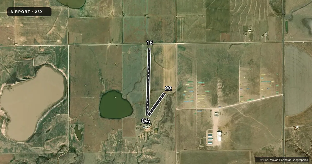
Full pagePattern entry · RWY 18
LEFT TRAFFICAirport sketch
Runways drawn to scale from FAA survey coordinates, rendered over satellite imagery. Not for navigation.
Approaches & charts
Services on the field
Fuel grades, oxygen, maintenance, ramp storage and lighting — as declared to the FAA by the airport operator.
Fuel & services
- Fuel
- Not available
Ramp & ground
- Transient storage
- Not published
- Wind indicator
- Yes
Fuel & FBOs
Cheapest 100LL and Jet A on the field and nearby. Always confirm with the FBO before taxi.
Airport notes
Surface conditions, obstructions, local procedures, lighting outages and other notes published with each FAA cycle.
General notes
- FOR CD CTC ALBUQUERQUE ARTCC AT 505-856-4861.
- ACTIVE PASTURE, LIVESTOCK MAY BE ON RWY. CALL FOR FIELD CONDS.
Other notes
- OWNERTCONEAL14@GMAIL.COM
VFR map & nearby airports
VFR sectional. Tap any ICAO chip to open that airport.
Key facts · 28X
Answer card- ICAO
- 28X
- Name
- GREEN ACRES AIRFIELD
- Location
- PAMPA, TEXAS
- Elevation
- 3,244.7 ft MSL
- Traffic pattern altitude
- 4,244.7 ft MSL (1,000 AGL)
- Control tower
- Non-towered (use CTAF)
- Total runways
- 2
- Longest runway
- 18/36 · 3,294 ft
- Published ILS approaches
- 0
- Published frequencies
- 0
- Magnetic variation
- –
- Current flight rules
- VFR
- Current wind
- 140° at 6 kt
- Favored runway now
- RWY 18
Green Acres Airfield sits in Pampa, Texas. The field elevation is 3,244.7 ft MSL. It has two turf runways. The longest is 18/36 at 3,294 ft. The other runway is 04/22 at 1,390 ft. There is no control tower. No ILS approaches are published here.
Pattern altitude is not published. Use standard light-piston pattern planning at 1,000 ft AGL unless the current FAA Chart Supplement says otherwise. At this elevation, expect thinner air and longer takeoff rolls than you would see at lower fields. That matters on a warm day.
No on-field FBOs are listed in the facts. Contact the airport operator directly before arrival if you need fuel or ramp details. Published remarks list an owner email contact at TCONEAL14@GMAIL.COM. They also say to contact Albuquerque ARTCC at 505-856-4861 for clearance delivery. This is useful if you are filing IFR or need a clearance before departure. With no tower and no published frequencies in the facts, verify current local procedures with the airport operator or the current FAA Chart Supplement before you go.