METAR & TAF T45
T45 does not publish a METAR.
Showing the nearest reporting station: KAMA (RICK HUSBAND AMARILLO INTL) · 18.8 NM away. Conditions at T45 may differ.
METAR · KAMA
Observed 19:53Z
KAMA 271953Z 15010KT 10SM CLR 39/11 A2997 RMK AO2 SLP076 T03890106
- Wind
- 150° @ 10 kt
- Visibility
- 10 SM
- Temp / Dew
- 39°C / 11°C
- Altimeter
- 29.97 inHg
- Clouds
- CLR
- Density alt
- 7,101 ft
- Ceiling
- Unlimited
- Rules
- VFR
Airport info & contacts
Manager on record, flight service, ARTCC, attendance schedule and pattern altitude — published by the FAA and refreshed every 28 days.
Location
- From city
- 1 NM NE
- VFR sectional
- DALLAS-FT WORTH
- ARTCC
- ZAB · ALBUQUERQUE
- NOTAM facility
- FTW (NOTAM-D)
Airport manager
- Name
- TERRY COFFEE
- Phone
- 806-537-3517
- Address
- P O BOX 129, PANHANDLE TX 79068
Flight service · Hours
- FSS FTW
- FORT WORTH1-800-WX-BRIEF
- Attendance
- Unattended
Frequencies
Tap any row to copy the frequency to your clipboard.
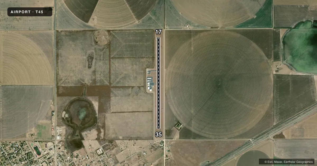
Runways & pattern
Full pagePattern entry · RWY 17
LEFT TRAFFICRunway end performance
| End | TORA | TODA | ASDA | LDA | VGSI | Approach lights | Obstruction |
|---|---|---|---|---|---|---|---|
| 35 | — | — | — | — | — | — | 15', road, 201' from thr, 210' R of cntrln, slope 0 |
Declared distances in feet. TORA = takeoff run available, TODA = takeoff distance, ASDA = accelerate-stop, LDA = landing distance.
Airport sketch
Runways drawn to scale from FAA survey coordinates, rendered over satellite imagery. Not for navigation.
Approaches & charts
Services on the field
Fuel grades, oxygen, maintenance, ramp storage and lighting — as declared to the FAA by the airport operator.
Fuel & services
- Fuel
- 100LL
- Other services
- AGRI
Ramp & ground
- Transient storage
- Tie-down
- Lighting schedule
- SEE RMK
- Beacon schedule
- SS-SR
- Beacon
- White / Green (civil land)(WG)
- Wind indicator
- Lighted
- Segmented circle
- Yes
Fuel & FBOs
Cheapest 100LL and Jet A on the field and nearby. Always confirm with the FBO before taxi.
Airport notes
Surface conditions, obstructions, local procedures, lighting outages and other notes published with each FAA cycle.
General notes
- FOR CD CTC ALBUQUERQUE ARTCC AT 505-856-4861.
Lighting notes
- MIRL RWY 17/35 PRESET LOW INTST; TO INCR INTST ACTVT - 123.5.
Approach & departure obstructions
- 3515 FT ROAD, 0-199 FT DSTC, 210 FT L.
Other notes
- MANAGERCITY MANAGER.
VFR map & nearby airports
VFR sectional. Tap any ICAO chip to open that airport.
Key facts · T45
Answer card- ICAO
- T45
- Name
- PANHANDLE-CARSON COUNTY
- Location
- PANHANDLE, TEXAS
- Elevation
- 3,453.7 ft MSL
- Traffic pattern altitude
- 4,453.7 ft MSL (1,000 AGL)
- Control tower
- Non-towered (use CTAF)
- Total runways
- 1
- Longest runway
- 17/35 · 4,404 ft
- Published ILS approaches
- 0
- Published frequencies
- 4
- Magnetic variation
- 8°
- Current flight rules
- VFR
- Current wind
- 150° at 10 kt
- Favored runway now
- RWY 17
Panhandle-Carson County Airport (T45) sits in Panhandle, Texas. The field elevation is 3,453.7 ft MSL. It has one runway. Runway 17/35 is 4,404 ft long and asphalt. There is no control tower, so expect non-towered ops on CTAF 122.7 or UNICOM 122.7.
No ILS approaches are published here. Pattern altitude is not published in the facts, so use the standard 1,000 ft AGL for light piston traffic unless the current Chart Supplement says otherwise. The airport sits in the Texas Panhandle. Density altitude can matter here because of the elevation. Plan performance with that in mind.
Published remarks note medium intensity runway lights on 17/35. They are preset to low intensity. If you need more light, activate them on 123.5. There is also a 15-foot road obstruction near runway 35, 210 feet left of the centerline and within 0 to 199 feet of the threshold area. That is worth checking on final and in your takeoff planning.
No on-field FBOs are listed in the facts. Contact the airport operator directly before arrival, or call the field on CTAF or UNICOM for current FBO availability. For clearance delivery, contact Albuquerque ARTCC at 505-856-4861.