METAR & TAF H81
H81 does not publish a METAR.
Showing the nearest reporting station: KAMA (RICK HUSBAND AMARILLO INTL) · 8.6 NM away. Conditions at H81 may differ.
METAR · KAMA
Observed 18:53Z
KAMA 271853Z 15011G16KT 10SM CLR 39/12 A2999 RMK AO2 SLP083 T03890117
- Wind
- 150° @ 11G16 kt
- Visibility
- 10 SM
- Temp / Dew
- 39°C / 12°C
- Altimeter
- 29.99 inHg
- Clouds
- CLR
- Density alt
- 7,239 ft
- Ceiling
- Unlimited
- Rules
- VFR
Airport info & contacts
Manager on record, flight service, ARTCC, attendance schedule and pattern altitude — published by the FAA and refreshed every 28 days.
Location
- From city
- 9 NM SE
- VFR sectional
- DALLAS-FT WORTH
- ARTCC
- ZAB · ALBUQUERQUE
- NOTAM facility
- H81
Airport manager
- Name
- HANNES TRNKA
- Phone
- 806-206-6525
- Address
- 13301 WILD HORSE TRL, AMARILLO TX 79118
Flight service · Hours
- FSS FTW
- FORT WORTH1-800-WX-BRIEF
- Attendance
- 0700-1900
Frequencies
Tap any row to copy the frequency to your clipboard.
Runways & pattern
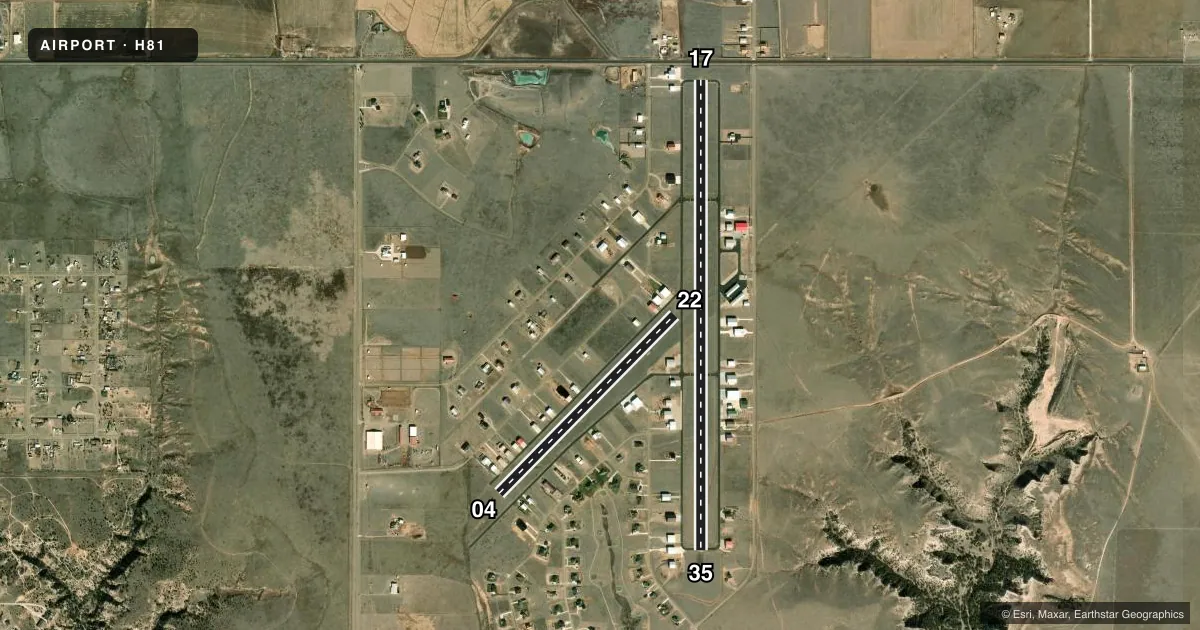
Full pagePattern entry · RWY 17
LEFT TRAFFIC| Runway | Heading (°M) | Length | Surface | Traffic |
|---|---|---|---|---|
| 17/35Favored | 180° / 0° | 6,015 ft | ASPH | 35 R |
| 04/22 | 44° / 224° | 3,200 ft | TURF | 04 R |
Runway end performance
| End | TORA | TODA | ASDA | LDA | VGSI | Approach lights | Obstruction |
|---|---|---|---|---|---|---|---|
| 17 | — | — | — | — | — | — | 15', road, 210' from thr, 135' R of cntrln, slope 0 |
Declared distances in feet. TORA = takeoff run available, TODA = takeoff distance, ASDA = accelerate-stop, LDA = landing distance.
Airport sketch
Runways drawn to scale from FAA survey coordinates, rendered over satellite imagery. Not for navigation.
Approaches & charts
Services on the field
Fuel grades, oxygen, maintenance, ramp storage and lighting — as declared to the FAA by the airport operator.
Fuel & services
- Fuel
- 100LLA1+
- Oxygen (bottled)
- Low pressure
- Airframe repair
- Minor
- Power plant repair
- Minor
Ramp & ground
- Transient storage
- Tie-down
- Hangar
- Landing fee
- No fee published
- Lighting schedule
- SEE RMK
- Beacon schedule
- SS-SR
- Beacon
- White / Green (civil land)(WG)
- Wind indicator
- Yes
Fuel & FBOs
Cheapest 100LL and Jet A on the field and nearby. Always confirm with the FBO before taxi.
Airport notes
Surface conditions, obstructions, local procedures, lighting outages and other notes published with each FAA cycle.
General notes
- FOR CD CTC ALBUQUERQUE ARTCC AT 505-856-4861.
Lighting notes
- ACTVT MIRL RWY 17/35 - CTAF. CLICK PTT SLOWLY, NO MORE THAN ONCE PER SEC.
Fuel notes
- 100LLFOR FUEL CALL 806-306-6525.
Approach & departure obstructions
- 178 FT FENCE 180 FT FM THR, 135 FT L/R.
- 17RWY 17 DSPLCD THR MKD AT 415 FT, NOT LGTD. DAY LEN 6015 FT, NIGHT LEN 5000 FT.
- 17APCH RATIO 50:1 TO DSPLCD THR.
VFR map & nearby airports
VFR sectional. Tap any ICAO chip to open that airport.
Key facts · H81
Answer card- ICAO
- H81
- Name
- RIVER FALLS
- Location
- AMARILLO, TEXAS
- Elevation
- 3,585 ft MSL
- Traffic pattern altitude
- 4,585 ft MSL (1,000 AGL)
- Control tower
- Non-towered (use CTAF)
- Total runways
- 2
- Longest runway
- 17/35 · 6,015 ft
- Published ILS approaches
- 0
- Published frequencies
- 2
- Magnetic variation
- –
- Current flight rules
- VFR
- Current wind
- 150° at 11 kt
- Favored runway now
- RWY 17
River Falls is in Amarillo, Texas. Field elevation is 3,585 ft MSL. The airport has two runways. The longest is 17/35 at 6,015 ft asphalt. Runway 04/22 is 3,200 ft turf. There is no control tower. CTAF and UNICOM are both 122.725.
No ILS approaches are published here. Pattern altitude is not published, so use the standard 1,000 ft AGL for light piston operations unless the current Chart Supplement says otherwise. That puts you at 4,585 ft MSL on a normal pattern day.
Redline Aviation is on the field. It carries 100LL, Jet A and Jet A Prist. Max FBO is also on the field. Fuel grades are not reported for Max, so call ahead if you need a specific product. Published remarks matter here. Runway 17 has a displaced threshold marked 415 ft from the end. The day length is 6,015 ft. Night length is 5,000 ft. There is also an 8 ft fence near the threshold. For runway 17 lighting, activate the medium intensity lights on CTAF with slow microphone clicks. Clearance delivery is handled through Albuquerque ARTCC. This is a high-elevation field in the Texas Panhandle. Performance planning matters.