METAR & TAF I06
I06 does not publish a METAR.
Showing the nearest reporting station: KPVW (HALE COUNTY) · 24.1 NM away. Conditions at I06 may differ.
METAR · KPVW
Observed 08:30Z
KPVW 270830Z AUTO 21008KT 10SM CLR 23/14 A3003 RMK AO2 T02320138
- Wind
- 210° @ 8 kt
- Visibility
- 10 SM
- Temp / Dew
- 23°C / 14°C
- Altimeter
- 30.03 inHg
- Clouds
- CLR
- Density alt
- 5,167 ft
- Ceiling
- Unlimited
- Rules
- VFR
Airport info & contacts
Manager on record, flight service, ARTCC, attendance schedule and pattern altitude — published by the FAA and refreshed every 28 days.
Location
- From city
- 2 NM NW
- VFR sectional
- DALLAS-FT WORTH
- ARTCC
- ZFW · FORT WORTH
- NOTAM facility
- FTW (NOTAM-D)
Airport manager
- Name
- MICHAEL CLAWSON, CO. JUDGE
- Phone
- 806-786-2773
- Address
- SWISHER CO. COURTHOUSE, 119 S. MAXWELL, TULIA TX 79088
Flight service · Hours
- FSS FTW
- FORT WORTH1-800-WX-BRIEF
- Attendance
- INTMNT
Frequencies
Tap any row to copy the frequency to your clipboard.
Runways & pattern
Full pagePattern entry · RWY 19
LEFT TRAFFICRunway end performance
| End | TORA | TODA | ASDA | LDA | VGSI | Approach lights | Obstruction |
|---|---|---|---|---|---|---|---|
| 01 | — | — | — | — | — | — | 15', road, 550' from thr, 160' R of cntrln, slope 23 |
Declared distances in feet. TORA = takeoff run available, TODA = takeoff distance, ASDA = accelerate-stop, LDA = landing distance.
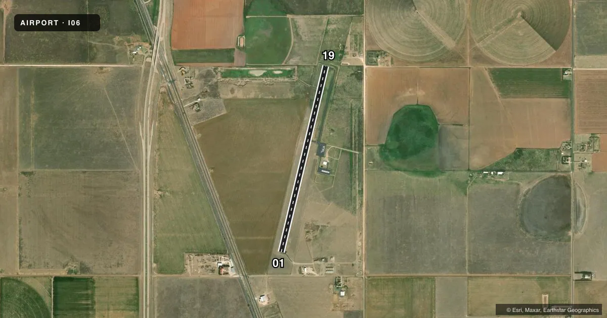
Airport sketch
Runways drawn to scale from FAA survey coordinates, rendered over satellite imagery. Not for navigation.
Approaches & charts
Services on the field
Fuel grades, oxygen, maintenance, ramp storage and lighting — as declared to the FAA by the airport operator.
Fuel & services
- Fuel
- 100LL
- Oxygen (bottled)
- Not available
- Oxygen (bulk)
- Not available
Ramp & ground
- Transient storage
- Tie-down
- Landing fee
- No fee published
- Customs
- Not available
- Lighting schedule
- SEE RMK
- Beacon schedule
- SS-SR
- Beacon
- White / Green (civil land)(WG)
- Wind indicator
- Lighted
- Segmented circle
- Yes
Fuel & FBOs
Cheapest 100LL and Jet A on the field and nearby. Always confirm with the FBO before taxi.
Airport notes
Surface conditions, obstructions, local procedures, lighting outages and other notes published with each FAA cycle.
General notes
- LIVESTOCK INVOF ARPT.
- FOR CD CTC FORT WORTH ARTCC AT 817-858-7584.
Lighting notes
- MIRL RWY 01/19 PRESET LOW INTST; TO INCR INTST ACTVT - 122.8.
Fuel notes
- 100LLFUEL SELF SERVE. FOR ASSISTANCE CALL 806-995-3504 DURING REG. BUS. HRS.
Other notes
- THIS AIRPORT HAS BEEN SURVEYED BY THE NATIONAL GEODETIC SURVEY.
- MANAGERADD'L CONTACTS: B.J. POTTS, CITY MGR, 806-995-3547; DOUG BARNES, A&P, 806-786-2773.
VFR map & nearby airports
VFR sectional. Tap any ICAO chip to open that airport.
Key facts · I06
Answer card- ICAO
- I06
- Name
- CITY OF TULIA/SWISHER COUNTY MUNI
- Location
- TULIA, TEXAS
- Elevation
- 3,503 ft MSL
- Traffic pattern altitude
- 4,503 ft MSL (1,000 AGL)
- Control tower
- Non-towered (use CTAF)
- Total runways
- 1
- Longest runway
- 01/19 · 4,876 ft
- Published ILS approaches
- 0
- Published frequencies
- 2
- Magnetic variation
- 9°
- Current flight rules
- VFR
- Current wind
- 210° at 8 kt
- Favored runway now
- RWY 19
City of Tulia/Swisher County Muni sits in Tulia, Texas at 3,503 ft MSL. It has one runway, 01/19, which is 4,876 ft long. The field is non-towered. CTAF and UNICOM are both 122.7. No ILS approaches are published here.
The pattern altitude is not published. Use the standard 1,000 ft AGL pattern for light piston traffic unless the current Chart Supplement says otherwise. The airport carries self-serve 100LL through Swisher County Municipal Airport. Call the field at (806) 995-3504 if you need help during regular business hours. The published remarks also note livestock in the vicinity of the airport, so keep that in mind on arrival and departure.
Runway lighting on 01/19 is medium intensity. It is preset to low intensity. Increase it by keying 122.8. For clearance delivery, contact Fort Worth ARTCC at 817-858-7584. This field is surveyed by the National Geodetic Survey. With 3,503 ft elevation, expect density altitude to matter on warm days. Check performance before you go. If you need current noise or operational restrictions, verify them in the current FAA Chart Supplement or with the airport operator.