METAR & TAF 29F
29F does not publish a METAR.
Showing the nearest reporting station: KPVW (HALE COUNTY) · 13.7 NM away. Conditions at 29F may differ.
METAR · KPVW
Observed 07:50Z
KPVW 260750Z AUTO 20006KT 10SM CLR 25/16 A3010 RMK AO2 T02500162
- Wind
- 200° @ 6 kt
- Visibility
- 10 SM
- Temp / Dew
- 25°C / 16°C
- Altimeter
- 30.10 inHg
- Clouds
- CLR
- Density alt
- 5,317 ft
- Ceiling
- Unlimited
- Rules
- VFR
Airport info & contacts
Manager on record, flight service, ARTCC, attendance schedule and pattern altitude — published by the FAA and refreshed every 28 days.
Location
- From city
- 1 NM N
- VFR sectional
- DALLAS-FT WORTH
- ARTCC
- ZFW · FORT WORTH
- NOTAM facility
- FTW (NOTAM-D)
Airport manager
- Name
- JOHN VAUGHN
- Phone
- 806-684-2732
- Address
- 629 US HIGHWAY 87, KRESS TX 79052
Flight service · Hours
- FSS FTW
- FORT WORTH1-800-WX-BRIEF
- Attendance
- MON-FRI · 0800-1800
- SAT-SUN · IREG
Frequencies
Tap any row to copy the frequency to your clipboard.
Runways & pattern
Full pagePattern entry · RWY 17
LEFT TRAFFICRunway end performance
| End | TORA | TODA | ASDA | LDA | VGSI | Approach lights | Obstruction |
|---|---|---|---|---|---|---|---|
| 17 | — | — | — | — | — | — | 15', road, 16' from thr, 135' R of cntrln, slope 1 |
| 35 | — | — | — | — | — | — | 4', fence, 0' from thr, 30' R of cntrln, slope 0 |
Declared distances in feet. TORA = takeoff run available, TODA = takeoff distance, ASDA = accelerate-stop, LDA = landing distance.
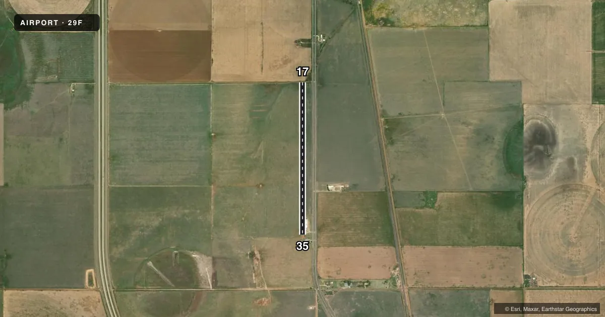
Airport sketch
Runways drawn to scale from FAA survey coordinates, rendered over satellite imagery. Not for navigation.
Approaches & charts
Services on the field
Fuel grades, oxygen, maintenance, ramp storage and lighting — as declared to the FAA by the airport operator.
Fuel & services
- Fuel
- 100LLA
- Airframe repair
- Major
- Power plant repair
- Major
- Other services
- AGRI
Ramp & ground
- Transient storage
- Not published
- Landing fee
- No fee published
- Wind indicator
- Lighted
- Segmented circle
- No
Fuel & FBOs
Cheapest 100LL and Jet A on the field and nearby. Always confirm with the FBO before taxi.
Airport notes
Surface conditions, obstructions, local procedures, lighting outages and other notes published with each FAA cycle.
General notes
- RWY 17 +30 FT PLINE 46 FT DSTC 77 FT RIGHT CNTRLN.
- 25 FT BLDGS 45 FT RIGHT OF CNTRLN AT RWY 35 END.
- 5 FT FENCE 40 FT WEST OF RWY CNTRLN, FULL LEN OF RWY.
- FOR CD CTC FORT WORTH ARTCC AT 817-858-7584.
Fuel notes
- 100LLJET A FOR AG ACFT ONLY.
Other notes
- PROVIDED THR RWY 17 IS DSPLCD TO PROVIDE REQUIRED CLEARANCE OVER COUNTY ROAD/300' FOR THE DIRT RWY.
- 17/35SFC ROUGH.
VFR map & nearby airports
VFR sectional. Tap any ICAO chip to open that airport.
Key facts · 29F
Answer card- ICAO
- 29F
- Name
- JOE VAUGHN SPRAYING
- Location
- KRESS, TEXAS
- Elevation
- 3,500 ft MSL
- Traffic pattern altitude
- 4,500 ft MSL (1,000 AGL)
- Control tower
- Non-towered (use CTAF)
- Total runways
- 1
- Longest runway
- 17/35 · 3,900 ft
- Published ILS approaches
- 0
- Published frequencies
- 2
- Magnetic variation
- 9°
- Current flight rules
- VFR
- Current wind
- 200° at 6 kt
- Favored runway now
- RWY 17
Joe Vaughn Spraying Airport sits near Kress, Texas. Field elevation is 3,500 ft MSL. The airport has one runway. Runway 17/35 is 3,900 ft long and surfaced with dirt. The runway is rough. The threshold for runway 17 is displaced to clear the county road and to account for the dirt runway length. There is no control tower. CTAF and UNICOM are both 122.7.
No ILS approaches are published here. Pattern altitude is not published, so use the standard 1,000 ft AGL pattern unless current local guidance says otherwise. That puts the light piston pattern at 4,500 ft MSL based on the field elevation. The airport sits in open country with a 9° magnetic variation. Expect a non-towered rural field where runway condition and obstacle clearance matter more than convenience.
Published remarks call out a 30-foot power line near runway 17. There are also 25-foot buildings near the runway 35 end. A 5-foot fence runs west of the centerline along the full length of the runway. Fort Worth ARTCC handles clearance delivery. No on-field FBOs are listed, so verify services directly before you go. Jet A is for agricultural aircraft only. For a first-time arrival, the main things to brief are the rough dirt surface, the displaced threshold on 17 and the nearby obstructions at both ends.