METAR & TAF KHRX
Current METAR
Observed 20:35Z
KHRX 272035Z AUTO 21009G16KT 10SM CLR 40/10 A2998 RMK AO2 T04010100 TSNO
- Wind
- 210° @ 9G16 kt
- Visibility
- 10 SM
- Temp / Dew
- 40°C / 10°C
- Altimeter
- 29.98 inHg
- Clouds
- CLR
- Density alt
- 7,622 ft
- Ceiling
- Unlimited
- Rules
- VFR
Airport info & contacts
Manager on record, flight service, ARTCC, attendance schedule and pattern altitude — published by the FAA and refreshed every 28 days.
Location
- From city
- 4 NM NE
- VFR sectional
- ALBUQUERQUE
- ARTCC
- ZAB · ALBUQUERQUE
- NOTAM facility
- FTW (NOTAM-D)
Airport manager
- Name
- CAYDEN FINCH
- Phone
- 806-344-7710
- Address
- 4175 US HWY 60, HEREFORD TX 79045
Flight service · Hours
- FSS FTW
- FORT WORTH1-800-WX-BRIEF
- Attendance
- 0800-1700
Frequencies
Tap any row to copy the frequency to your clipboard.
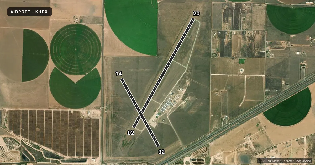
Runways & pattern
Full pagePattern entry · RWY 20
LEFT TRAFFIC| Runway | Heading (°M) | Length | Surface | Traffic |
|---|---|---|---|---|
| 02/20Favored | 20° / 200° | 6,100 ft | CONC | Standard L |
| 14/32 | 142° / 322° | 3,807 ft | TURF | Standard L |
Runway end performance
| End | TORA | TODA | ASDA | LDA | VGSI | Approach lights | Obstruction |
|---|---|---|---|---|---|---|---|
| 02 | — | — | — | — | PAPI 4-box left(3°) | — | 45', pline, 2335' from thr, 596' R of cntrln, slope 47 |
| 20 | — | — | — | — | PAPI 4-box left(3°) | — | — |
| 14 | — | — | — | — | — | — | 50', pline, 1400' from thr, 280' R of cntrln, slope 28 |
| 32 | — | — | — | — | — | — | 50', pline, 1200' from thr, 0' R of cntrln, slope 24 |
Declared distances in feet. TORA = takeoff run available, TODA = takeoff distance, ASDA = accelerate-stop, LDA = landing distance.
Airport sketch
Runways drawn to scale from FAA survey coordinates, rendered over satellite imagery. Not for navigation.
Approaches & charts
Services on the field
Fuel grades, oxygen, maintenance, ramp storage and lighting — as declared to the FAA by the airport operator.
Fuel & services
- Fuel
- 100LLA
- Oxygen (bottled)
- Not available
- Oxygen (bulk)
- Not available
- Airframe repair
- Major
- Power plant repair
- Major
- Other services
- AGRI,INSTR
Ramp & ground
- Transient storage
- Tie-down
- Hangar
- Landing fee
- No fee published
- Customs
- Not available
- Lighting schedule
- SEE RMK
- Beacon schedule
- SS-SR
- Beacon
- White / Green (civil land)(WG)
- Wind indicator
- Lighted
- Segmented circle
- Yes
Fuel & FBOs
Cheapest 100LL and Jet A on the field and nearby. Always confirm with the FBO before taxi.
Airport notes
Surface conditions, obstructions, local procedures, lighting outages and other notes published with each FAA cycle.
General notes
- FOR CD CTC ALBUQUERQUE ARTCC AT 505-856-4861.
Lighting notes
- MIRL RWY 02/20 PRESET LOW INTST SS-SR. TO ACTVT MIRL 02/20 OR INCR INTST - CTAF. PAPI RWY 02 & 20 OPR CONSLY.
Fuel notes
- 100LL24 HRS SELF-SERVE.
Approach & departure obstructions
- 14THR MKD WITH 10 X 60 FT CONCRETE PAD ACRS END.
- 32THR MKD WITH 10 X 60 FT CONCRETE PAD ACRS END.
VFR map & nearby airports
VFR sectional. Tap any ICAO chip to open that airport.
Key facts · KHRX
Answer card- ICAO
- KHRX
- Name
- HEREFORD MUNI
- Location
- HEREFORD, TEXAS
- Elevation
- 3,787.6 ft MSL
- Traffic pattern altitude
- 4,787.6 ft MSL (1,000 AGL)
- Control tower
- Non-towered (use CTAF)
- Total runways
- 2
- Longest runway
- 02/20 · 6,100 ft
- Published ILS approaches
- 0
- Published frequencies
- 6
- Magnetic variation
- 9°
- Current flight rules
- VFR
- Current wind
- 210° at 9 kt
- Favored runway now
- RWY 20
Hereford Muni is in Hereford, Texas. The field elevation is 3,787.6 ft MSL. It has two runways. The longest is runway 02/20 at 6,100 ft. Runway 14/32 is turf at 3,807 ft. There is no control tower. No ILS approaches are published here. The pattern altitude is not published, so use the standard 1,000 ft AGL for light piston operations unless the current FAA Chart Supplement says otherwise.
The on-field FBO is Hereford Municipal Airport. It carries 100LL and Jet A. 100LL is available 24 hours by self-serve. Runway 02/20 has medium intensity lights that come up in low intensity from sunset to sunrise. Use CTAF to activate or increase the lights. The PAPI on runways 02 and 20 operates continuously. The threshold of runway 14 and the threshold of runway 32 are both marked with a 10 by 60 ft concrete pad across the end.
This is a non-towered field with Amarillo approach and departure frequencies in use. Check the current FAA Chart Supplement for any local noise or operating notes before you go. The elevation is high enough that performance planning matters, especially on a warm day. If you need clearance delivery, Albuquerque ARTCC is listed in the remarks.