METAR & TAF KTDW
KTDW does not publish a METAR.
Showing the nearest reporting station: KAMA (RICK HUSBAND AMARILLO INTL) · 6.6 NM away. Conditions at KTDW may differ.
METAR · KAMA
Observed 15:53Z
KAMA 271553Z 23009KT 10SM CLR 33/14 A3004 RMK AO2 SLP101 T03330144
- Wind
- 230° @ 9 kt
- Visibility
- 10 SM
- Temp / Dew
- 33°C / 14°C
- Altimeter
- 30.04 inHg
- Clouds
- CLR
- Density alt
- 6,535 ft
- Ceiling
- Unlimited
- Rules
- VFR
Airport info & contacts
Manager on record, flight service, ARTCC, attendance schedule and pattern altitude — published by the FAA and refreshed every 28 days.
Location
- From city
- 3 NM SE
- VFR sectional
- DALLAS-FT WORTH
- ARTCC
- ZAB · ALBUQUERQUE
- NOTAM facility
- FTW (NOTAM-D)
Airport manager
- Name
- JON KUEHLER
- Phone
- 806-376-1008
- Address
- 4105 TRADEWIND ST, AMARILLO TX 79118
Flight service · Hours
- FSS FTW
- FORT WORTH1-800-WX-BRIEF
- Attendance
- 0700-2200
Frequencies
Tap any row to copy the frequency to your clipboard.
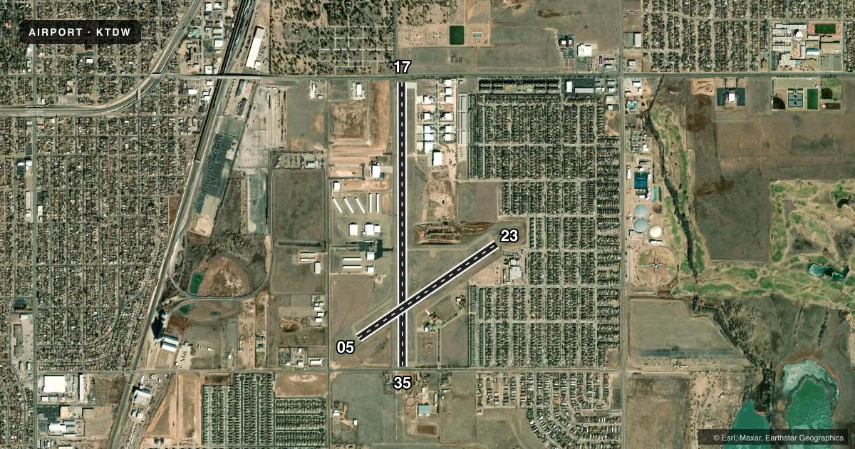
Runways & pattern
Full pagePattern entry · RWY 23
RIGHT TRAFFIC| Runway | Heading (°M) | Length | Surface | Traffic |
|---|---|---|---|---|
| 17/35 | 172° / 352° | 5,098 ft | ASPH | 17 R |
| 05/23Favored | 48° / 228° | 3,000 ft | ASPH | 23 R |
Runway end performance
| End | TORA | TODA | ASDA | LDA | VGSI | Approach lights | Obstruction |
|---|---|---|---|---|---|---|---|
| 17 | — | — | — | — | — | — | 30', tree, 201' from thr, 133' R of cntrln, slope 0 |
| 35 | — | — | — | — | — | — | 30', trees, 300' from thr, 220' R of cntrln, slope 3 |
| 05 | — | — | — | — | — | — | 4', fence, 200' from thr, 99' R of cntrln, slope 0 |
| 23 | — | — | — | — | — | — | 23', pole, 854' from thr, 29' R of cntrln, slope 29 |
Declared distances in feet. TORA = takeoff run available, TODA = takeoff distance, ASDA = accelerate-stop, LDA = landing distance.
Airport sketch
Runways drawn to scale from FAA survey coordinates, rendered over satellite imagery. Not for navigation.
Approaches & charts
Services on the field
Fuel grades, oxygen, maintenance, ramp storage and lighting — as declared to the FAA by the airport operator.
Fuel & services
- Fuel
- 100LLA1+
- Oxygen (bottled)
- High pressure
- Airframe repair
- Major
- Power plant repair
- Major
- Other services
- AFRT,AMB,CHTR,INSTR,RNTL
Ramp & ground
- Transient storage
- Tie-down
- Hangar
- Landing fee
- No fee published
- Customs
- Not available
- Lighting schedule
- SEE RMK
- Beacon schedule
- SS-SR
- Beacon
- White / Green (civil land)(WG)
- Wind indicator
- Lighted
- Segmented circle
- Yes
Fuel & FBOs
Cheapest 100LL and Jet A on the field and nearby. Always confirm with the FBO before taxi.
Airport notes
Surface conditions, obstructions, local procedures, lighting outages and other notes published with each FAA cycle.
General notes
- FOR CD CTC ALBUQUERQUE ARTCC AT 505-856-4861.
- RWY 5/23 NO MKGS.
Lighting notes
- MIRL RWY 17/35 SS-SR PRESET LOW. TO INCR INTST AND ACTVT REIL RWY 17, 35; MIRL RWY 05/23 - CTAF.
Approach & departure obstructions
- 054 FT FENCE 0 FT DSTC, 99 FT R.
- 174 FT FENCE 24 FT DSTC; 14 FT RD 43 FT DSTC, 250 L/R.
- 236 FT FENCE 94 FT DSTC, 60 FT L.
- 354 FT FENCE 0 FT DSTC; 15 FT RD, 47 FT DSTC.
- 17APCH SLOPE 11:1 AT DSPLCD THR OVR 40 FT POLE, 456 FT DSTC, 270 FT L.
- 35APCH SLOPE 0:1 AT DSPLCD THR OVR 4 FT FENCE 189 LEFT.
- H135 FT PLINE 440 FT SOUTH OF HELIPAD; 35 FT PLINE, MKD 157 FT WEST; 30 FT LGT POLE 171 FT EAST, 25 FT LGTD WIND SOCK 96 FT WEST.
Other notes
- THIS AIRPORT HAS BEEN SURVEYED BY THE NATIONAL GEODETIC SURVEY.
- 1AFT HRS SVC 806-376-1008.
- MANAGERCELL 720-412-1132
VFR map & nearby airports
VFR sectional. Tap any ICAO chip to open that airport.
Key facts · KTDW
Answer card- ICAO
- KTDW
- Name
- TRADEWIND
- Location
- AMARILLO, TEXAS
- Elevation
- 3,648.5 ft MSL
- Traffic pattern altitude
- 4,648.5 ft MSL (1,000 AGL)
- Control tower
- Non-towered (use CTAF)
- Total runways
- 2
- Longest runway
- 17/35 · 5,098 ft
- Published ILS approaches
- 0
- Published frequencies
- 7
- Magnetic variation
- 8°
- Current flight rules
- VFR
- Current wind
- 230° at 9 kt
- Favored runway now
- RWY 23
Tradewind Airport sits in Amarillo, Texas at 3,648.5 ft MSL. It has two asphalt runways. The longest is 17/35 at 5,098 ft. The other runway is 05/23 at 3,000 ft. There is no control tower, so plan for CTAF traffic and self-announce work. Pattern altitude is not published. For light piston operations, use the standard 1,000 ft AGL pattern unless the current Chart Supplement says otherwise.
No ILS approaches are published here. That matters in low ceilings or reduced visibility. The field also has several published obstructions close to the runway ends. Runway 23 has a fence near the departure end. Runway 35 has fence and road notes near the threshold. Runway 17 has a fence and road near the end, plus a displaced-threshold slope note over a pole. Give the runway environment a careful look on arrival and departure.
Tradewind Airport has one on-field FBO, Tradewind Airport. It carries AVGAS 100LL and Jet A Prist. After-hours service is available by phone. Runway lighting on 17/35 is preset low from sunset to sunrise. Use CTAF to raise intensity and to activate runway end identifier lights on 17 and 35. Runway 05/23 lighting is controlled by CTAF. For clearance delivery, the published remarks direct pilots to Albuquerque ARTCC. The airport is in the Amarillo area, so expect busy radio work and high-density summer performance planning at this elevation.