METAR & TAF 41F
41F does not publish a METAR.
Showing the nearest reporting station: KPVW (HALE COUNTY) · 21.7 NM away. Conditions at 41F may differ.
METAR · KPVW
Observed 06:30Z
KPVW 240630Z AUTO 21011KT 10SM CLR 23/16 A3005 RMK AO2 T02250155
- Wind
- 210° @ 11 kt
- Visibility
- 10 SM
- Temp / Dew
- 23°C / 16°C
- Altimeter
- 30.05 inHg
- Clouds
- CLR
- Density alt
- 4,751 ft
- Ceiling
- Unlimited
- Rules
- VFR
Airport info & contacts
Manager on record, flight service, ARTCC, attendance schedule and pattern altitude — published by the FAA and refreshed every 28 days.
Location
- From city
- 1 NM N
- VFR sectional
- DALLAS-FT WORTH
- ARTCC
- ZFW · FORT WORTH
- NOTAM facility
- FTW (NOTAM-D)
Airport manager
- Name
- MITCH PROBASCO
- Phone
- 806-983-2314
- Address
- PO BOX 128, FLOYDADA TX 79235-0128
Flight service · Hours
- FSS FTW
- FORT WORTH1-800-WX-BRIEF
- Attendance
- MON-SAT · 0800-1800
Frequencies
Tap any row to copy the frequency to your clipboard.
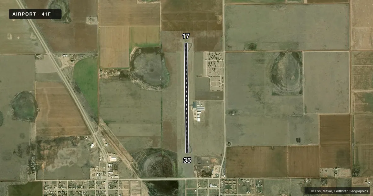
Runways & pattern
Full pagePattern entry · RWY 17
LEFT TRAFFICRunway end performance
| End | TORA | TODA | ASDA | LDA | VGSI | Approach lights | Obstruction |
|---|---|---|---|---|---|---|---|
| 17 | — | — | — | — | PAPI 2-box left(3°) | — | — |
| 35 | — | — | — | — | PAPI 2-box left(3°) | — | 155', bldg, 3300' from thr, 326' R of cntrln, slope 20 |
Declared distances in feet. TORA = takeoff run available, TODA = takeoff distance, ASDA = accelerate-stop, LDA = landing distance.
Airport sketch
Runways drawn to scale from FAA survey coordinates, rendered over satellite imagery. Not for navigation.
Approaches & charts
Services on the field
Fuel grades, oxygen, maintenance, ramp storage and lighting — as declared to the FAA by the airport operator.
Fuel & services
- Fuel
- 100LLA
- Other services
- AGRI
Ramp & ground
- Transient storage
- Tie-down
- Hangar
- Landing fee
- No fee published
- Customs
- Not available
- Lighting schedule
- SEE RMK
- Beacon schedule
- SS-SR
- Beacon
- White / Green (civil land)(WG)
- Wind indicator
- Lighted
- Segmented circle
- Yes
Fuel & FBOs
Cheapest 100LL and Jet A on the field and nearby. Always confirm with the FBO before taxi.
Airport notes
Surface conditions, obstructions, local procedures, lighting outages and other notes published with each FAA cycle.
General notes
- EXTSV AERIAL AG OPS.
- FOR CD CTC FORT WORTH ARTCC AT 817-858-7584.
Lighting notes
- DUSK-DAWN. MIRL RWY 17/35 PRESET TO LOW INTST; TO INCR INTST OR ACTVT - CTAF.
VFR map & nearby airports
VFR sectional. Tap any ICAO chip to open that airport.
Key facts · 41F
Answer card- ICAO
- 41F
- Name
- FLOYDADA MUNI
- Location
- FLOYDADA, TEXAS
- Elevation
- 3,187.2 ft MSL
- Traffic pattern altitude
- 4,187.2 ft MSL (1,000 AGL)
- Control tower
- Non-towered (use CTAF)
- Total runways
- 1
- Longest runway
- 17/35 · 4,600 ft
- Published ILS approaches
- 0
- Published frequencies
- 6
- Magnetic variation
- 7°
- Current flight rules
- VFR
- Current wind
- 210° at 11 kt
- Favored runway now
- RWY 17
Floydada Muni sits in Floydada, Texas. Field elevation is 3,187.2 ft MSL. The airport has one runway, 17/35, which is 4,600 ft long. There is no control tower. Pattern altitude is not published, so use the standard 1,000 ft AGL for light piston traffic unless the current Chart Supplement says otherwise. That puts the usual pattern around 4,187.2 ft MSL.
No ILS approaches are published here. CTAF and UNICOM are both 122.8. Approach and departure service is handled by Lubbock on the published frequencies. Probasco Flying Service is on the field. It carries 100LL and Jet A. Call ahead at (806) 983-2314 for current service details.
The published remarks matter here. Extensive aerial agricultural work occurs at the airport, so expect low-level traffic and stay sharp in the pattern. Runway 17/35 has medium intensity lights that come up in low intensity from dusk to dawn. Use CTAF to increase the lights if needed. For clearance delivery, contact Fort Worth Center. This is a non-towered field in open country with a high field elevation, so density altitude can be a factor on warm days. Plan performance with that in mind and verify any current operational notes in the FAA Chart Supplement before departure.