METAR & TAF F82
F82 does not publish a METAR.
Showing the nearest reporting station: KLBB (LUBBOCK PRESTON SMITH INTL) · 10.8 NM away. Conditions at F82 may differ.
METAR · KLBB
Observed 15:53Z
KLBB 271553Z 20009KT 10SM CLR 30/16 A3003 RMK AO2 SLP107 T03000161
- Wind
- 200° @ 9 kt
- Visibility
- 10 SM
- Temp / Dew
- 30°C / 16°C
- Altimeter
- 30.03 inHg
- Clouds
- CLR
- Density alt
- 5,601 ft
- Ceiling
- Unlimited
- Rules
- VFR
Airport info & contacts
Manager on record, flight service, ARTCC, attendance schedule and pattern altitude — published by the FAA and refreshed every 28 days.
Location
- From city
- 5 NM S
- VFR sectional
- DALLAS-FT WORTH
- ARTCC
- ZFW · FORT WORTH
- NOTAM facility
- FTW (NOTAM-D)
Airport manager
- Name
- DREW MORRISON
- Phone
- 806-745-4967
- Address
- 12201 COUNTY RD. 2500, LUBBOCK TX 79404
Flight service · Hours
- FSS FTW
- FORT WORTH1-800-WX-BRIEF
- Attendance
- 0700-2100
Frequencies
Tap any row to copy the frequency to your clipboard.
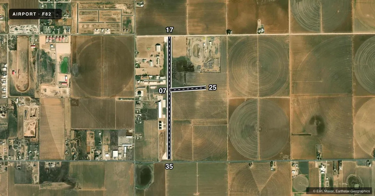
Runways & pattern
Full pagePattern entry · RWY 17
LEFT TRAFFIC| Runway | Heading (°M) | Length | Surface | Traffic |
|---|---|---|---|---|
| 17/35Favored | 175° / 355° | 5,144 ft | CONC-TRTD | Standard L |
| 07/25 | 81° / 261° | 1,524 ft | TURF | Standard L |
Runway end performance
| End | TORA | TODA | ASDA | LDA | VGSI | Approach lights | Obstruction |
|---|---|---|---|---|---|---|---|
| 07 | — | — | — | — | — | — | 48', pline, 1450' from thr, 122' R of cntrln, slope 30 |
Declared distances in feet. TORA = takeoff run available, TODA = takeoff distance, ASDA = accelerate-stop, LDA = landing distance.
Airport sketch
Runways drawn to scale from FAA survey coordinates, rendered over satellite imagery. Not for navigation.
Approaches & charts
Services on the field
Fuel grades, oxygen, maintenance, ramp storage and lighting — as declared to the FAA by the airport operator.
Fuel & services
- Fuel
- 100LLA1+
- Oxygen (bottled)
- Not available
- Oxygen (bulk)
- Not available
- Airframe repair
- Major
- Power plant repair
- Major
- Other services
- INSTR,RNTL,SALES
Ramp & ground
- Transient storage
- Tie-down
- Hangar
- Landing fee
- No fee published
- Customs
- Not available
- Lighting schedule
- SS-SR
- Beacon schedule
- SS-SR
- Beacon
- White / Green (civil land)(WG)
- Wind indicator
- Yes
- Segmented circle
- No
Fuel & FBOs
Cheapest 100LL and Jet A on the field and nearby. Always confirm with the FBO before taxi.
Airport notes
Surface conditions, obstructions, local procedures, lighting outages and other notes published with each FAA cycle.
General notes
- FARM EQUIP OPRS APCH END RWYS 17, 25, 35.
- FOR CD CTC FORT WORTH ARTCC AT 817-858-7584.
- RWY 07/25 35 FT TREES ALG N RWY EDGE.
- NO TWY MRKGS.
Fuel notes
- 100LL100LL & JET A1+ FULL SERV DURG ATNDD HRS; SELF-SERVE 24 HRS.
Approach & departure obstructions
- 1715 FT RD, 15 FT DSTC, 125 FT L/R.
- 355 FT SIGN, 58 FT DSTC; 3 FT ELEC BOX, 75 FT DSTC; 15 FT RD, 48 FT DSTC, 125 FT L/R.
- 17APCH SLOPE 4:1 TO DSPLCD THR OVR 15 FT RD, 73 FT DSTC.
Other notes
- 1AFT HRS 806-440-6210.
- MANAGERALT PHONE NR 806-440-6210. DREW@CLEARTECHAVIATION.COM
- INSTRGPU/START CART AVBL.
- 07/25RWY ROUGH WITH BARE SPOTS. RWY DEFINED BY MOWING.
VFR map & nearby airports
VFR sectional. Tap any ICAO chip to open that airport.
Key facts · F82
Answer card- ICAO
- F82
- Name
- LUBBOCK EXEC AIRPARK
- Location
- LUBBOCK, TEXAS
- Elevation
- 3,175.7 ft MSL
- Traffic pattern altitude
- 4,175.7 ft MSL (1,000 AGL)
- Control tower
- Non-towered (use CTAF)
- Total runways
- 2
- Longest runway
- 17/35 · 5,144 ft
- Published ILS approaches
- 0
- Published frequencies
- 4
- Magnetic variation
- 5°
- Current flight rules
- VFR
- Current wind
- 200° at 9 kt
- Favored runway now
- RWY 17
Lubbock Exec Airpark sits in Lubbock, Texas at 3,175.7 ft MSL. It has two runways. The longest is 5,144 ft on Runway 17/35. The field is not towered. CTAF and UNICOM are both 122.8. No ILS approaches are published here, so plan on non-precision or visual work only if conditions allow.
Pattern altitude is not published. For light piston traffic, use the standard 1,000 ft AGL unless the current Chart Supplement or local procedures say otherwise. That puts the pattern around 4,176 ft MSL based on the field elevation. The airport sits in a high plains environment. Density altitude can matter here, especially in warm weather.
ClearTech Aviation is on the field. It carries 100LL and Jet A Prist. Self-serve fuel is available 24 hours. Ground power and a start cart are also available. The published remarks call out rough turf on Runway 07/25 with bare spots. The runway is defined by mowing. There are no taxiway markings. Runway 07/25 also has 35-foot trees along the north edge. Farm equipment operates near the approach ends of Runways 17, 25 and 35. Check the current Chart Supplement and brief carefully before arrival.