METAR & TAF KLLN
Current METAR
Observed 17:15Z
KLLN 271715Z AUTO 17009KT 9SM CLR 33/15 A3005 RMK AO2
- Wind
- 170° @ 9 kt
- Visibility
- 9 SM
- Temp / Dew
- 33°C / 15°C
- Altimeter
- 30.05 inHg
- Clouds
- CLR
- Density alt
- 6,356 ft
- Ceiling
- Unlimited
- Rules
- VFR
Airport info & contacts
Manager on record, flight service, ARTCC, attendance schedule and pattern altitude — published by the FAA and refreshed every 28 days.
Location
- From city
- 2 NM S
- VFR sectional
- ALBUQUERQUE
- ARTCC
- ZFW · FORT WORTH
- NOTAM facility
- FTW (NOTAM-D)
Airport manager
- Name
- RICHARD HARVEY
- Phone
- 806-470-8768
- Address
- P.O. BOX 1624, LEVELLAND TX 79336
Flight service · Hours
- FSS FTW
- FORT WORTH1-800-WX-BRIEF
- Attendance
- MON-FRI · 0800-1600
Frequencies
Tap any row to copy the frequency to your clipboard.
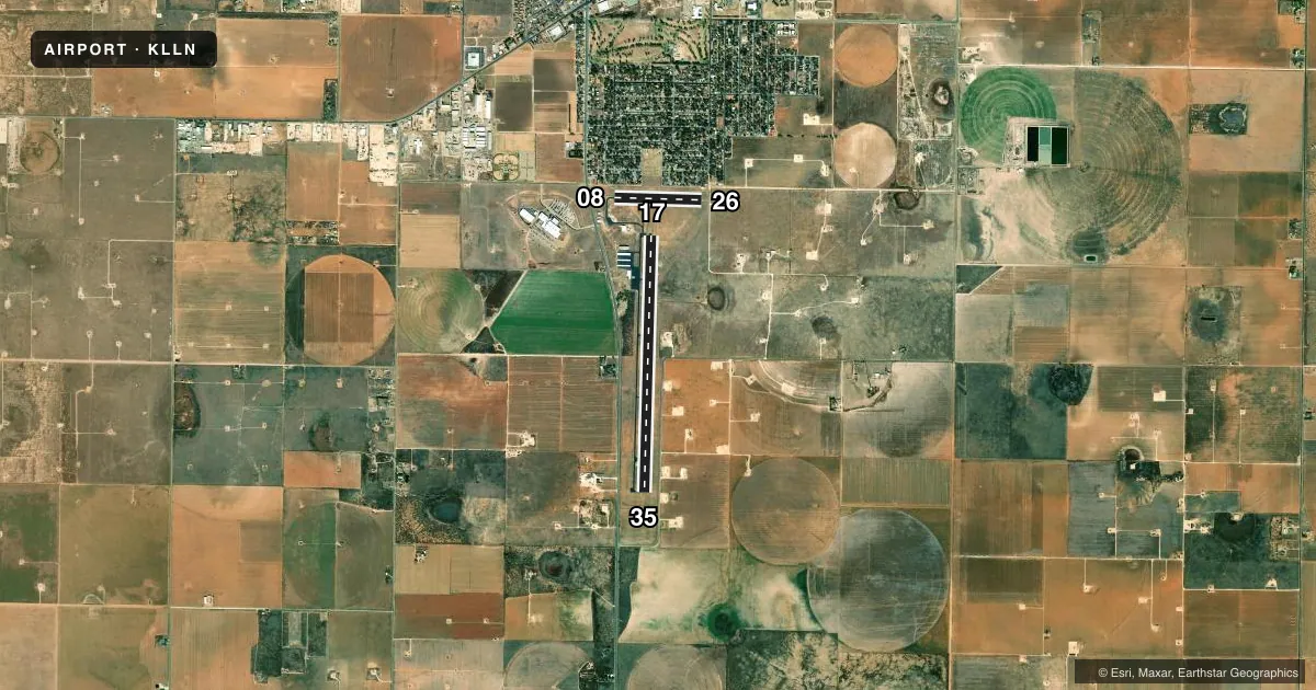
Runways & pattern
Full pagePattern entry · RWY 17
LEFT TRAFFIC| Runway | Heading (°M) | Length | Surface | Traffic |
|---|---|---|---|---|
| 17/35Favored | 173° / 353° | 6,110 ft | ASPH | 35 R |
| 08/26 | 83° / 263° | 2,072 ft | ASPH | 08 R |
Runway end performance
| End | TORA | TODA | ASDA | LDA | VGSI | Approach lights | Obstruction |
|---|---|---|---|---|---|---|---|
| 17 | — | — | — | — | PAPI 4-box left(3°) | — | 48', tree, 1345' from thr, 285' R of cntrln, slope 23 |
| 35 | — | — | — | — | PAPI 4-box left(3°) | — | — |
| 08 | — | — | — | — | — | — | 15', road, 604' from thr, 165' R of cntrln, slope 26 |
| 26 | — | — | — | — | — | — | 10', road, 202' from thr, 127' R of cntrln, slope 0 |
Declared distances in feet. TORA = takeoff run available, TODA = takeoff distance, ASDA = accelerate-stop, LDA = landing distance.
Airport sketch
Runways drawn to scale from FAA survey coordinates, rendered over satellite imagery. Not for navigation.
Approaches & charts
Services on the field
Fuel grades, oxygen, maintenance, ramp storage and lighting — as declared to the FAA by the airport operator.
Fuel & services
- Fuel
- 100LLA
- Airframe repair
- Major
- Power plant repair
- Major
- Other services
- AGRI
Ramp & ground
- Transient storage
- Tie-down
- Landing fee
- No fee published
- Customs
- Not available
- Lighting schedule
- SEE RMK
- Beacon schedule
- SS-SR
- Beacon
- White / Green (civil land)(WG)
- Wind indicator
- Lighted
- Segmented circle
- Yes
Fuel & FBOs
Cheapest 100LL and Jet A on the field and nearby. Always confirm with the FBO before taxi.
Airport notes
Surface conditions, obstructions, local procedures, lighting outages and other notes published with each FAA cycle.
General notes
- FOR CD CTC FORT WORTH ARTCC AT 817-858-7584.
- ACFT NOT VISIBLE FROM OPPOSITE RWY END.
Lighting notes
- MIRL RWY 17/35 PRESET LOW INTST; TO INCR INTST ACTVT - CTAF.
Fuel notes
- 100LLFUEL SELF-SVC.
Approach & departure obstructions
- 264 FT FENCE, 185 FT DSTC, 125 FT L/R.
- 08PRIVATE RD.
Other notes
- THIS AIRPORT HAS BEEN SURVEYED BY THE NATIONAL GEODETIC SURVEY.
VFR map & nearby airports
VFR sectional. Tap any ICAO chip to open that airport.
Key facts · KLLN
Answer card- ICAO
- KLLN
- Name
- LEVELLAND MUNI
- Location
- LEVELLAND, TEXAS
- Elevation
- 3,514.1 ft MSL
- Traffic pattern altitude
- 4,514.1 ft MSL (1,000 AGL)
- Control tower
- Non-towered (use CTAF)
- Total runways
- 2
- Longest runway
- 17/35 · 6,110 ft
- Published ILS approaches
- 0
- Published frequencies
- 6
- Magnetic variation
- 9°
- Current flight rules
- VFR
- Current wind
- 170° at 9 kt
- Favored runway now
- RWY 17
Levelland Muni is in Levelland, Texas. The field elevation is 3,514.1 ft MSL. It has two asphalt runways. The longest is runway 17/35 at 6,110 ft. There is no control tower. Pattern altitude is not published, so use the standard 1,000 ft AGL for light piston traffic unless the current Chart Supplement says otherwise.
No ILS approaches are published here. For IFR work, you will be dealing with the Lubbock approach and departure frequencies listed for the field. CTAF and UNICOM are both 122.8. Levelland Aero Services is on the field. It carries 100LL and Jet A. Fuel is self-serve 100LL.
A few remarks matter on the ground. Runway 17/35 lights are medium intensity and start at low intensity. Use the CTAF to increase them. There is a private road near runway 08. A 4-foot fence sits near runway 26, about 185 ft away and offset left or right. Aircraft are not visible from the opposite runway end, so keep your scan disciplined in the pattern. This is a high-elevation West Texas airport, so expect density altitude to matter on warm days. Check the current FAA Chart Supplement for any additional local notes before you go.