METAR & TAF T96
T96 does not publish a METAR.
Showing the nearest reporting station: KLBB (LUBBOCK PRESTON SMITH INTL) · 18.8 NM away. Conditions at T96 may differ.
METAR · KLBB
Observed 12:53Z
KLBB 271253Z 19006KT 10SM FEW120 FEW250 24/16 A3003 RMK AO2 SLP108 T02390156 $
- Wind
- 190° @ 6 kt
- Visibility
- 10 SM
- Temp / Dew
- 24°C / 16°C
- Altimeter
- 30.03 inHg
- Clouds
- FEW
- Density alt
- 4,992 ft
- Ceiling
- Unlimited
- Rules
- VFR
Airport info & contacts
Manager on record, flight service, ARTCC, attendance schedule and pattern altitude — published by the FAA and refreshed every 28 days.
Location
- From city
- 7 NM S
- VFR sectional
- ALBUQUERQUE
- ARTCC
- ZFW · FORT WORTH
- NOTAM facility
- FTW
Airport manager
- Name
- JOE GRIMES
- Phone
- 806-787-6681
- Address
- 21103 FM 179, WOLFFORTH TX 79382
Flight service · Hours
- FSS FTW
- FORT WORTH1-800-WX-BRIEF
- Attendance
- Unattended
Frequencies
Tap any row to copy the frequency to your clipboard.
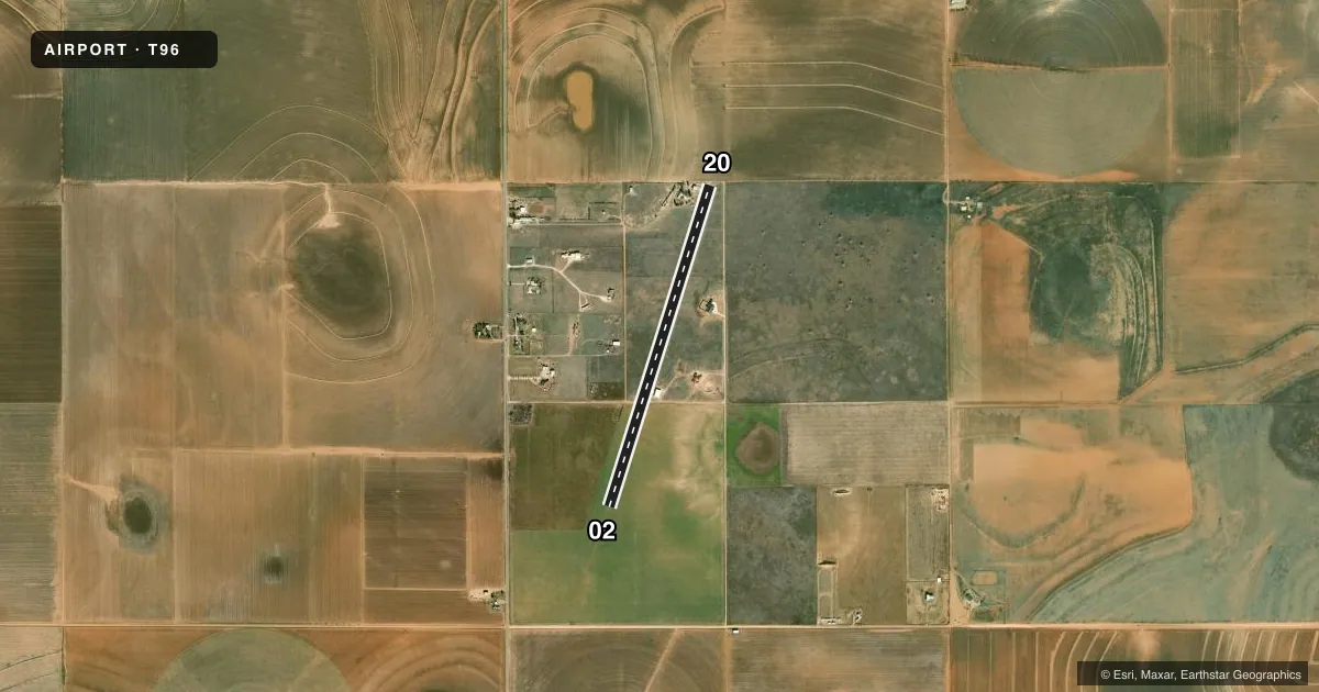
Runways & pattern
Full pagePattern entry · RWY 20
RIGHT TRAFFICAirport sketch
Runways drawn to scale from FAA survey coordinates, rendered over satellite imagery. Not for navigation.
Approaches & charts
Services on the field
Fuel grades, oxygen, maintenance, ramp storage and lighting — as declared to the FAA by the airport operator.
Fuel & services
- Fuel
- Not available
Ramp & ground
- Transient storage
- Not published
- Lighting schedule
- SS-SR
- Wind indicator
- Yes
Fuel & FBOs
Cheapest 100LL and Jet A on the field and nearby. Always confirm with the FBO before taxi.
Airport notes
Surface conditions, obstructions, local procedures, lighting outages and other notes published with each FAA cycle.
General notes
- FOR CD CTC FORT WORTH ARTCC AT 817-858-7584.
- SEASONAL CROPS AT EACH RWY END.
Runway surface & condition
- 02/20SOLAR LIGHTS.
Other notes
- WINDSOCK LCTD MIDFIELD & NORTH END.
- OWNERPROPERTY OWNER: JOE AND JEAN GRIMES TRUST
- MANAGERJOE@GRIMESENGINEERING.COM
VFR map & nearby airports
VFR sectional. Tap any ICAO chip to open that airport.
Key facts · T96
Answer card- ICAO
- T96
- Name
- SOUTHWEST LUBBOCK
- Location
- WOLFFORTH, TEXAS
- Elevation
- 3,265 ft MSL
- Traffic pattern altitude
- 4,265 ft MSL (1,000 AGL)
- Control tower
- Non-towered (use CTAF)
- Total runways
- 1
- Longest runway
- 02/20 · 4,000 ft
- Published ILS approaches
- 0
- Published frequencies
- 1
- Magnetic variation
- –
- Current flight rules
- VFR
- Current wind
- 190° at 6 kt
- Favored runway now
- RWY 20
Southwest Lubbock (T96) sits in Wolfforth, Texas. The field elevation is 3,265 ft MSL. It has one runway. Runway 02/20 is 4,000 ft long with asphalt pavement. The airport is non-towered. CTAF is 122.9.
No ILS approaches are published here. Pattern altitude is not published, so use the standard 1,000 ft AGL for light piston traffic unless the current Chart Supplement says otherwise. That puts the pattern at 4,265 ft MSL based on the listed field elevation. Runway 02/20 has solar lights. Windsocks are located at midfield and the north end.
There are no on-field FBOs listed. Plan ahead for fuel or services and confirm current availability with the airport operator or the FBO directly by phone before departure. Published remarks also note seasonal crops at each runway end, so watch your approach and departure path closely. For clearance delivery, contact Fort Worth ARTCC at 817-858-7584. If you need current operational details, check the current FAA Chart Supplement before you go.