METAR & TAF 2F4
2F4 does not publish a METAR.
Showing the nearest reporting station: KLUV (LAMESA MUNI) · 26.0 NM away. Conditions at 2F4 may differ.
METAR · KLUV
Observed 17:10Z
KLUV 271710Z AUTO 17007KT 10SM CLR 32/18 A3003 RMK AO2
- Wind
- 170° @ 7 kt
- Visibility
- 10 SM
- Temp / Dew
- 32°C / 18°C
- Altimeter
- 30.03 inHg
- Clouds
- CLR
- Density alt
- 5,780 ft
- Ceiling
- Unlimited
- Rules
- VFR
Airport info & contacts
Manager on record, flight service, ARTCC, attendance schedule and pattern altitude — published by the FAA and refreshed every 28 days.
Location
- From city
- 1 NM NW
- VFR sectional
- DALLAS-FT WORTH
- ARTCC
- ZFW · FORT WORTH
- NOTAM facility
- FTW (NOTAM-D)
Airport manager
- Name
- SAMMY PRIDMORE
- Phone
- 806-759-1455
- Address
- 1807 MAIN ST,, PO BOX 300, TAHOKA TX 79373
Flight service · Hours
- FSS FTW
- FORT WORTH1-800-WX-BRIEF
- Attendance
- Unattended · ON CALL
Frequencies
Tap any row to copy the frequency to your clipboard.
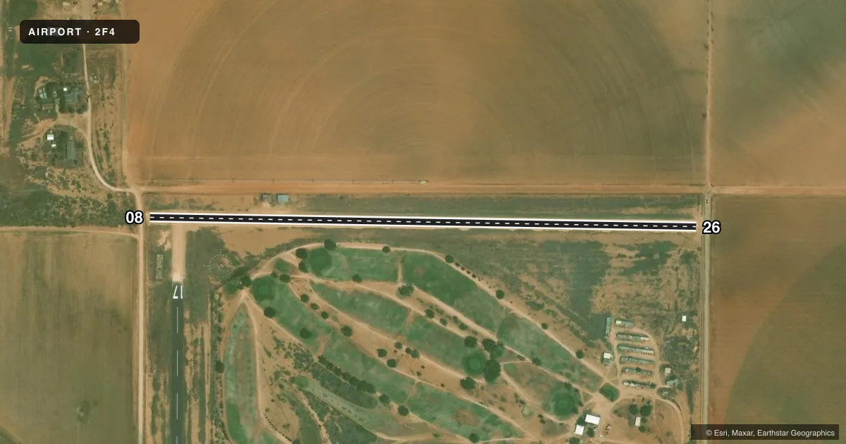
Runways & pattern
Full pagePattern entry · RWY 08
LEFT TRAFFICRunway end performance
| End | TORA | TODA | ASDA | LDA | VGSI | Approach lights | Obstruction |
|---|---|---|---|---|---|---|---|
| 08 | — | — | — | — | — | — | 12', road, 30' from thr, 0' R of cntrln, slope 2 |
| 26 | — | — | — | — | — | — | 11', road, 30' from thr, 0' R of cntrln, slope 3 |
Declared distances in feet. TORA = takeoff run available, TODA = takeoff distance, ASDA = accelerate-stop, LDA = landing distance.
Airport sketch
Runways drawn to scale from FAA survey coordinates, rendered over satellite imagery. Not for navigation.
Approaches & charts
Services on the field
Fuel grades, oxygen, maintenance, ramp storage and lighting — as declared to the FAA by the airport operator.
Fuel & services
- Fuel
- Not available
Ramp & ground
- Transient storage
- Tie-down
- Hangar
- Landing fee
- No fee published
- Customs
- Not available
- Lighting schedule
- SS-SR
- Beacon
- White / Green (civil land)(WG)
- Wind indicator
- Lighted
- Segmented circle
- No
Fuel & FBOs
Cheapest 100LL and Jet A on the field and nearby. Always confirm with the FBO before taxi.
Airport notes
Surface conditions, obstructions, local procedures, lighting outages and other notes published with each FAA cycle.
General notes
- RWY 08/26 THRS & RWY EDGES NOT DEFINED.
- 20 FT AGL IRRIGATION EQUIP 400 FT NORTH AER 35.
- FOR CD CTC FORT WORTH ARTCC AT 817-858-7584.
- RWY 8/26 5 FT DROP OFF EACH END.
Approach & departure obstructions
- 17IRRIGATION EQUIP.
Other notes
- UNICOM OTS INDEFLY.
- 1ATTENDANT ON CALL 806-759-1455.
VFR map & nearby airports
VFR sectional. Tap any ICAO chip to open that airport.
Key facts · 2F4
Answer card- ICAO
- 2F4
- Name
- T-BAR
- Location
- TAHOKA, TEXAS
- Elevation
- 3,126 ft MSL
- Traffic pattern altitude
- 4,126 ft MSL (1,000 AGL)
- Control tower
- Non-towered (use CTAF)
- Total runways
- 1
- Longest runway
- 08/26 · 2,543 ft
- Published ILS approaches
- 0
- Published frequencies
- 2
- Magnetic variation
- 9°
- Current flight rules
- VFR
- Current wind
- 170° at 7 kt
- Favored runway now
- RWY 08
T-BAR Airport sits in Tahoka, Texas. Field elevation is 3,126 ft MSL. The airport has one runway. Runway 08/26 is 2,543 ft long with a gravel-dirt surface. The published runway headings are magnetic 91° and 271°. No tower is on site. CTAF is 122.8. UNICOM is also listed as 122.8. The published remarks say UNICOM is out of service indefinitely.
No ILS approaches are published here. Pattern altitude is not published. For a light piston, use the standard 1,000 ft AGL unless the current Chart Supplement says otherwise. That puts the traffic pattern at about 4,126 ft MSL based on the field elevation. Check the current Chart Supplement before you go. The remarks also say runway 08/26 has a 5 ft drop-off at each end. The runway threshold and edges are not defined. Irrigation equipment may be near the runway. There is also 20 ft AGL irrigation equipment 400 ft north of the approach end of runway 35.
No on-field FBOs are listed. Extensive aerial agricultural operations may occur from May through October. Runway lighting is out of service indefinitely. The beacon is out of service indefinitely. For clearance delivery, contact Fort Worth ARTCC at 817-858-7584. The city manager is the airport manager. For emergencies, call 806-561-5255.