METAR & TAF 5F1
5F1 does not publish a METAR.
Showing the nearest reporting station: KSNK (WINSTON FLD) · 36.3 NM away. Conditions at 5F1 may differ.
METAR · KSNK
Observed 15:15Z
KSNK 271515Z AUTO 20011KT 10SM 28/19 A3002 RMK AO2 T02750188
- Wind
- 200° @ 11 kt
- Visibility
- 10 SM
- Temp / Dew
- 28°C / 19°C
- Altimeter
- 30.02 inHg
- Clouds
- Clear
- Density alt
- 4,592 ft
- Ceiling
- Unlimited
- Rules
- VFR
Airport info & contacts
Manager on record, flight service, ARTCC, attendance schedule and pattern altitude — published by the FAA and refreshed every 28 days.
Location
- From city
- 2 NM E
- VFR sectional
- DALLAS-FT WORTH
- ARTCC
- ZFW · FORT WORTH
- NOTAM facility
- FTW (NOTAM-D)
Airport manager
- Name
- CHRIS ATKINSON
- Phone
- 806-759-7561
- Address
- P.O. BOX 53, POST TX 79356
Flight service · Hours
- FSS FTW
- FORT WORTH1-800-WX-BRIEF
- Attendance
- INTMNT
Frequencies
Tap any row to copy the frequency to your clipboard.
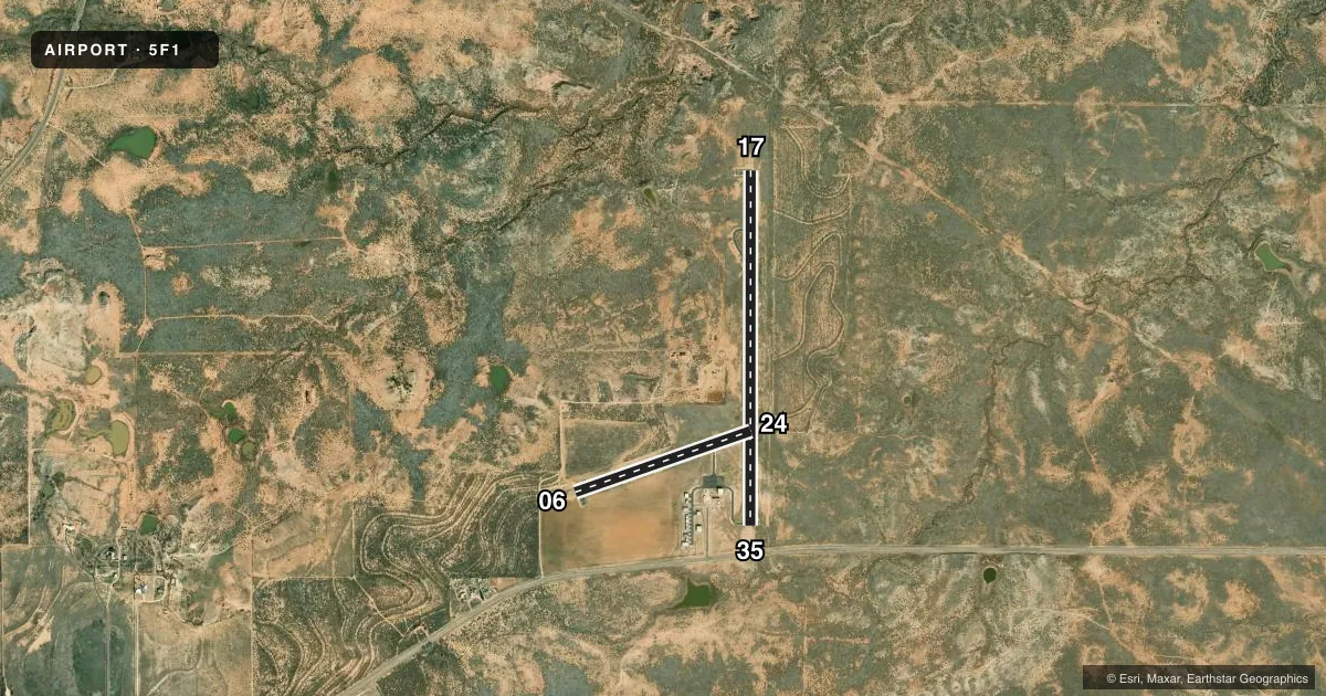
Runways & pattern
Full pagePattern entry · RWY 17
LEFT TRAFFIC| Runway | Heading (°M) | Length | Surface | Traffic |
|---|---|---|---|---|
| 17/35Favored | 169° / 349° | 4,200 ft | ASPH | Standard L |
| 06/24 | 60° / 240° | 2,210 ft | ASPH | Standard L |
Runway end performance
| End | TORA | TODA | ASDA | LDA | VGSI | Approach lights | Obstruction |
|---|---|---|---|---|---|---|---|
| 17 | — | — | — | — | PAPI 2-box left(3°) | — | — |
| 35 | — | — | — | — | — | — | 4', road, 325' from thr, 100' R of cntrln, slope 31 |
| 06 | — | — | — | — | — | — | 15', trees, 500' from thr, 0' R of cntrln, slope 20 |
| 24 | — | — | — | — | — | — | 4', fence, 234' from thr, 0' R of cntrln, slope 8 |
Declared distances in feet. TORA = takeoff run available, TODA = takeoff distance, ASDA = accelerate-stop, LDA = landing distance.
Airport sketch
Runways drawn to scale from FAA survey coordinates, rendered over satellite imagery. Not for navigation.
Approaches & charts
Services on the field
Fuel grades, oxygen, maintenance, ramp storage and lighting — as declared to the FAA by the airport operator.
Fuel & services
- Fuel
- Not available
- Oxygen (bottled)
- Not available
- Oxygen (bulk)
- Not available
- Airframe repair
- Not available
- Power plant repair
- Not available
Ramp & ground
- Transient storage
- Tie-down
- Landing fee
- No fee published
- Customs
- Not available
- Lighting schedule
- SS-SR
- Beacon schedule
- SS-SR
- Beacon
- White / Green (civil land)(WG)
- Wind indicator
- Lighted
- Segmented circle
- Yes
Fuel & FBOs
Cheapest 100LL and Jet A on the field and nearby. Always confirm with the FBO before taxi.
Airport notes
Surface conditions, obstructions, local procedures, lighting outages and other notes published with each FAA cycle.
General notes
- DEER AND FERAL HOGS ON AND INVOF ARPT.
- FOR CD CTC FORT WORTH ARTCC AT 817-858-7584.
Approach & departure obstructions
- 17PAVEMENT POOR, SEAL COAT SPALLING, LOOSE STONES AND ASPHALT.
- 35HWY 7 FT BLW RWY ELEV.
Other notes
- 06/24PAVEMENT POOR, SEAL COAT SPALLING, LOOSE STONES AND ASPHALT.
VFR map & nearby airports
VFR sectional. Tap any ICAO chip to open that airport.
Key facts · 5F1
Answer card- ICAO
- 5F1
- Name
- POST-GARZA COUNTY MUNI
- Location
- POST, TEXAS
- Elevation
- 2,545 ft MSL
- Traffic pattern altitude
- 3,545 ft MSL (1,000 AGL)
- Control tower
- Non-towered (use CTAF)
- Total runways
- 2
- Longest runway
- 17/35 · 4,200 ft
- Published ILS approaches
- 0
- Published frequencies
- 1
- Magnetic variation
- 11°
- Current flight rules
- VFR
- Current wind
- 200° at 11 kt
- Favored runway now
- RWY 17
Post-Garza County Muni is in Post, Texas. The field elevation is 2,545 ft MSL. It has two asphalt runways. The longest is 4,200 ft on runway 17/35. There is no control tower. CTAF is 122.9. No ILS approaches are published here.
The pattern altitude is not published. Use the standard 1,000 ft AGL for light piston operations unless the current Chart Supplement says otherwise. That puts the pattern at 3,545 ft MSL based on the listed field elevation. The airport sits in open West Texas country, so expect density altitude to matter on warm days. Deer and feral hogs are reported on and near the airport. A careful runway scan makes sense on taxi, takeoff and landing.
Runway 17 and runway 06/24 both have published pavement issues. The Chart Supplement notes seal coat spalling, loose stones and asphalt on those surfaces. Runway 35 has a highway about 7 ft below runway elevation near the threshold area. For clearance delivery, contact Fort Worth ARTCC at 817-858-7584. No on-field FBOs are listed, so verify fuel and services with the airport operator or the FBO directly by phone before you go.