METAR & TAF KSNK
Current METAR
Observed 11:35Z
KSNK 271135Z AUTO 18006KT 10SM 23/16 A2999 RMK AO2 T02330160
- Wind
- 180° @ 6 kt
- Visibility
- 10 SM
- Temp / Dew
- 23°C / 16°C
- Altimeter
- 29.99 inHg
- Clouds
- Clear
- Density alt
- 3,887 ft
- Ceiling
- Unlimited
- Rules
- VFR
Airport info & contacts
Manager on record, flight service, ARTCC, attendance schedule and pattern altitude — published by the FAA and refreshed every 28 days.
Location
- From city
- 2 NM SW
- VFR sectional
- DALLAS-FT WORTH
- ARTCC
- ZFW · FORT WORTH
- NOTAM facility
- SNK (NOTAM-D)
Airport manager
- Name
- DAVID KOONCE
- Phone
- 325-573-1122
- Address
- 2757 ROUND ROCK AVENUE, SNYDER TX 79549
Flight service · Hours
- FSS FTW
- FORT WORTH1-800-WX-BRIEF
- Attendance
- 0800-1800
Frequencies
Tap any row to copy the frequency to your clipboard.
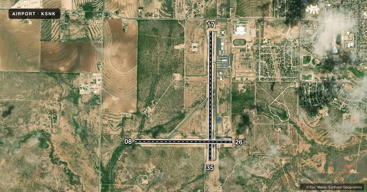
Runways & pattern
Full pagePattern entry · RWY 17
RIGHT TRAFFIC| Runway | Heading (°M) | Length | Surface | Traffic |
|---|---|---|---|---|
| 17/35Favored | 172° / 352° | 5,599 ft | ASPH | 17 R |
| 08/26 | 82° / 262° | 4,200 ft | ASPH | 08 R |
Runway end performance
| End | TORA | TODA | ASDA | LDA | VGSI | Approach lights | Obstruction |
|---|---|---|---|---|---|---|---|
| 17 | — | — | — | — | PAPI 4-box right(3°) | — | — |
| 35 | — | — | — | — | PAPI 4-box left(3°) | — | — |
| 08 | — | — | — | — | — | — | 14', trees, 201' from thr, 125' R of cntrln, slope 0 |
Declared distances in feet. TORA = takeoff run available, TODA = takeoff distance, ASDA = accelerate-stop, LDA = landing distance.
Airport sketch
Runways drawn to scale from FAA survey coordinates, rendered over satellite imagery. Not for navigation.
Approaches & charts
Services on the field
Fuel grades, oxygen, maintenance, ramp storage and lighting — as declared to the FAA by the airport operator.
Fuel & services
- Fuel
- 100LLA1
- Oxygen (bottled)
- Not available
- Oxygen (bulk)
- Not available
- Other services
- AMB
Ramp & ground
- Transient storage
- Tie-down
- Hangar
- Landing fee
- No fee published
- Customs
- Not available
- Lighting schedule
- SEE RMK
- Beacon schedule
- SS-SR
- Beacon
- White / Green (civil land)(WG)
- Wind indicator
- Lighted
- Segmented circle
- Yes
Fuel & FBOs
Cheapest 100LL and Jet A on the field and nearby. Always confirm with the FBO before taxi.
Airport notes
Surface conditions, obstructions, local procedures, lighting outages and other notes published with each FAA cycle.
General notes
- FOR CD IF UNA TO CTC ON FSS FREQ, CTC FORT WORTH ARTCC AT 817-858-7584.
- RWY 8/26 ACFT NOT VSB AT OPPOSITE RWY END.
Lighting notes
- DUSK-DAWN. MIRL RWY 17/35 PRESET LOW INTST; TO INCR INTST & ACTVT PAPI RWYS 17 & 35 - CTAF.
Approach & departure obstructions
- 088 FT FENCE, 175 FT DSTC, 125 FT L/R.
- 35PAPI UNUSBL BYD 9 DEGS LEFT AND RIGHT OF RWY CNTRLN.
- 08APCH SLOPE 21:1 TO RWY END.
Other notes
- THIS AIRPORT HAS BEEN SURVEYED BY THE NATIONAL GEODETIC SURVEY.
- 1ARPT UNATNDD THANKSGIVING, CHRISTMAS, AND EASTER. FOR ATNDT AFT HRS CALL 325-573-3551, CALL-IN FEE.
VFR map & nearby airports
VFR sectional. Tap any ICAO chip to open that airport.
Key facts · KSNK
Answer card- ICAO
- KSNK
- Name
- WINSTON FLD
- Location
- SNYDER, TEXAS
- Elevation
- 2,430.3 ft MSL
- Traffic pattern altitude
- 3,430.3 ft MSL (1,000 AGL)
- Control tower
- Non-towered (use CTAF)
- Total runways
- 2
- Longest runway
- 17/35 · 5,599 ft
- Published ILS approaches
- 0
- Published frequencies
- 2
- Magnetic variation
- 8°
- Current flight rules
- VFR
- Current wind
- 180° at 6 kt
- Favored runway now
- RWY 17
Winston Field sits in Snyder, Texas. The field elevation is 2,430.3 ft MSL. It has two asphalt runways. The longest is runway 17/35 at 5,599 ft. Runway 08/26 is 4,200 ft. There is no control tower. CTAF and UNICOM are both 122.8.
No ILS approaches are published here. Pattern altitude is not published, so use the standard 1,000 ft AGL for light piston operations unless the current Chart Supplement says otherwise. The on-field FBO is Winston Field. It carries 100LL and Jet A Prist. Call (325) 573-1122 for current service details.
A few published remarks matter for planning. Runway 17/35 lights sit at low intensity from dusk to dawn. Use CTAF to increase intensity and to activate the PAPI on runways 17 and 35. Runway 08 has an 8-foot fence near the approach side. The approach slope to runway 08 is 21 to 1 to the runway end. Aircraft on runway 8/26 are not visible from the opposite end, so keep your situational awareness tight on the ground. This is a higher-elevation Texas field, so expect density altitude to matter on warm days. Check the current Chart Supplement for any updated remarks before you go.