METAR & TAF T88
T88 does not publish a METAR.
Showing the nearest reporting station: KSNK (WINSTON FLD) · 13.6 NM away. Conditions at T88 may differ.
METAR · KSNK
Observed 15:55Z
KSNK 271555Z AUTO 20011G15KT 10SM 29/19 A3001 RMK AO2 T02880187
- Wind
- 200° @ 11G15 kt
- Visibility
- 10 SM
- Temp / Dew
- 29°C / 19°C
- Altimeter
- 30.01 inHg
- Clouds
- Clear
- Density alt
- 4,314 ft
- Ceiling
- Unlimited
- Rules
- VFR
Airport info & contacts
Manager on record, flight service, ARTCC, attendance schedule and pattern altitude — published by the FAA and refreshed every 28 days.
Location
- From city
- 6 NM NW
- VFR sectional
- DALLAS-FT WORTH
- ARTCC
- ZFW · FORT WORTH
- NOTAM facility
- FTW (NOTAM-D)
Airport manager
- Name
- DONNA MADRID
- Phone
- 325-728-3464
- Address
- PO BOX 912, COLORADO CITY TX 79512
Flight service · Hours
- FSS FTW
- FORT WORTH1-800-WX-BRIEF
- Attendance
- IREG
Frequencies
Tap any row to copy the frequency to your clipboard.
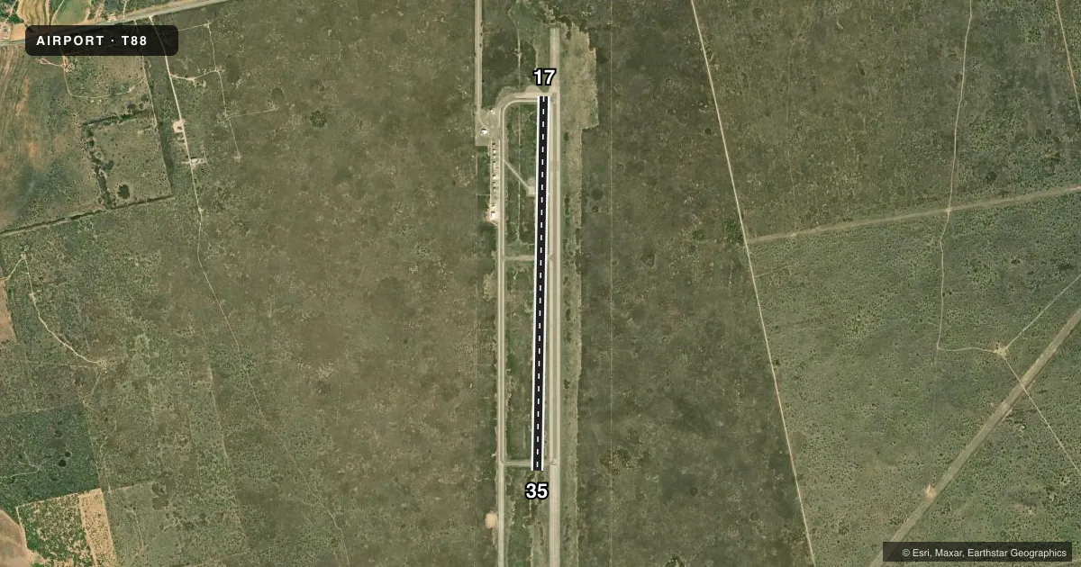
Runways & pattern
Full pagePattern entry · RWY 17
LEFT TRAFFICAirport sketch
Runways drawn to scale from FAA survey coordinates, rendered over satellite imagery. Not for navigation.
Approaches & charts
Services on the field
Fuel grades, oxygen, maintenance, ramp storage and lighting — as declared to the FAA by the airport operator.
Fuel & services
- Fuel
- Not available
- Oxygen (bottled)
- Not available
- Oxygen (bulk)
- Not available
- Airframe repair
- Not available
- Power plant repair
- Not available
- Other services
- AGRI
Ramp & ground
- Transient storage
- Tie-down
- Landing fee
- No fee published
- Customs
- Not available
- Lighting schedule
- SS-SR
- Beacon schedule
- SS-SR
- Beacon
- White / Green (civil land)(WG)
- Wind indicator
- Lighted
- Segmented circle
- Yes
Fuel & FBOs
Cheapest 100LL and Jet A on the field and nearby. Always confirm with the FBO before taxi.
Airport notes
Surface conditions, obstructions, local procedures, lighting outages and other notes published with each FAA cycle.
General notes
- FOR CD CTC FORT WORTH ARTCC AT 817-858-7584.
Runway surface & condition
- 17/35PAVEMENT FM RWY 35 THR LGTS SOUTH NOT MNTND.
- 17/35LOW INTST; LGTS 40 FT FM RWY EDGES.
Approach & departure obstructions
- 17NO CNTRLN.
- 35NO CNTRLN.
Other notes
- MANAGERCITY MANAGER
VFR map & nearby airports
VFR sectional. Tap any ICAO chip to open that airport.
Key facts · T88
Answer card- ICAO
- T88
- Name
- COLORADO CITY
- Location
- COLORADO CITY, TEXAS
- Elevation
- 2,214 ft MSL
- Traffic pattern altitude
- 3,214 ft MSL (1,000 AGL)
- Control tower
- Non-towered (use CTAF)
- Total runways
- 1
- Longest runway
- 17/35 · 5,479 ft
- Published ILS approaches
- 0
- Published frequencies
- 1
- Magnetic variation
- 8°
- Current flight rules
- VFR
- Current wind
- 200° at 11 kt
- Favored runway now
- RWY 17
Colorado City Airport is in Colorado City, Texas. The field elevation is 2,214 ft MSL. It has one runway, 17/35, which is 5,479 ft long. There is no control tower. CTAF is 122.9.
No ILS approaches are published here. The pattern altitude is not published, so use standard traffic pattern practice for light piston aircraft unless the current Chart Supplement says otherwise. Runway 17/35 has low-intensity lighting. The lights sit 40 feet from the runway edges. Runway 17 has no centerline. Runway 35 has no centerline. Pavement south of the runway 35 threshold lights is not maintained, so plan your rollout and taxi with that in mind.
There are no on-field FBOs listed in the facts. Contact the airport operator or the FBO directly by phone before arrival if you need fuel or ramp details. For clearance delivery, Fort Worth ARTCC handles it at 817-858-7584. The airport sits in west-central Texas at a moderate elevation, so density altitude can matter on warm days. Check performance carefully before departure. If you need current noise, curfew, or local operating guidance, verify it in the current FAA Chart Supplement before you go.