METAR & TAF 22F
22F does not publish a METAR.
Showing the nearest reporting station: KSNK (WINSTON FLD) · 37.5 NM away. Conditions at 22F may differ.
METAR · KSNK
Observed 13:35Z
KSNK 271335Z AUTO 18007KT 10SM 25/18 A3001 RMK AO2 T02480175
- Wind
- 180° @ 7 kt
- Visibility
- 10 SM
- Temp / Dew
- 25°C / 18°C
- Altimeter
- 30.01 inHg
- Clouds
- Clear
- Density alt
- 3,578 ft
- Ceiling
- Unlimited
- Rules
- VFR
Airport info & contacts
Manager on record, flight service, ARTCC, attendance schedule and pattern altitude — published by the FAA and refreshed every 28 days.
Location
- From city
- 1 NM S
- VFR sectional
- DALLAS-FT WORTH
- ARTCC
- ZFW · FORT WORTH
- NOTAM facility
- FTW (NOTAM-D)
Airport manager
- Name
- JIM WHITE
- Phone
- 806-237-3373
- Address
- P.O. BOX 6, JAYTON TX 79528
Flight service · Hours
- FSS FTW
- FORT WORTH1-800-WX-BRIEF
- Attendance
- Unattended
Frequencies
Tap any row to copy the frequency to your clipboard.
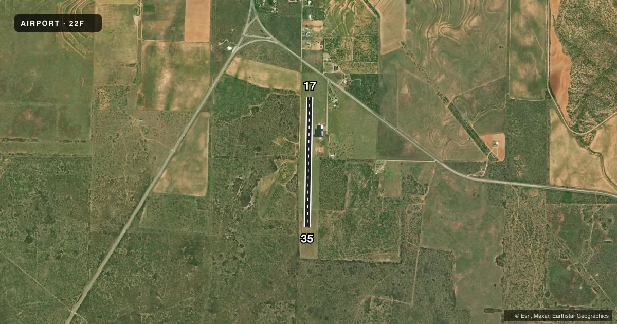
Runways & pattern
Full pagePattern entry · RWY 17
LEFT TRAFFICRunway end performance
| End | TORA | TODA | ASDA | LDA | VGSI | Approach lights | Obstruction |
|---|---|---|---|---|---|---|---|
| 17 | — | — | — | — | — | — | 22', road, 670' from thr, 170' R of cntrln, slope 21 |
| 35 | — | — | — | — | — | — | 25', trees, 800' from thr, 205' R of cntrln, slope 24 |
Declared distances in feet. TORA = takeoff run available, TODA = takeoff distance, ASDA = accelerate-stop, LDA = landing distance.
Airport sketch
Runways drawn to scale from FAA survey coordinates, rendered over satellite imagery. Not for navigation.
Approaches & charts
Services on the field
Fuel grades, oxygen, maintenance, ramp storage and lighting — as declared to the FAA by the airport operator.
Fuel & services
- Fuel
- Not available
- Oxygen (bottled)
- Not available
- Oxygen (bulk)
- Not available
- Airframe repair
- Not available
- Power plant repair
- Not available
Ramp & ground
- Transient storage
- Tie-down
- Landing fee
- No fee published
- Customs
- Not available
- Lighting schedule
- SS-SR
- Beacon schedule
- SS-SR
- Beacon
- White / Green (civil land)(WG)
- Wind indicator
- Lighted
- Segmented circle
- Yes
Fuel & FBOs
Cheapest 100LL and Jet A on the field and nearby. Always confirm with the FBO before taxi.
Airport notes
Surface conditions, obstructions, local procedures, lighting outages and other notes published with each FAA cycle.
General notes
- AGRICULTURAL ACTIVITY ON ARPT MAY-SEPT.
- FOR CD CTC FORT WORTH ARTCC AT 817-858-7584.
Other notes
- MANAGEREMERG CTC PHONE: 806-237-3801 (SHERIFF OFFICE)
VFR map & nearby airports
VFR sectional. Tap any ICAO chip to open that airport.
Key facts · 22F
Answer card- ICAO
- 22F
- Name
- KENT COUNTY
- Location
- JAYTON, TEXAS
- Elevation
- 2,008 ft MSL
- Traffic pattern altitude
- 3,008 ft MSL (1,000 AGL)
- Control tower
- Non-towered (use CTAF)
- Total runways
- 1
- Longest runway
- 17/35 · 3,300 ft
- Published ILS approaches
- 0
- Published frequencies
- 1
- Magnetic variation
- 8°
- Current flight rules
- VFR
- Current wind
- 180° at 7 kt
- Favored runway now
- RWY 17
Kent County Airport sits near Jayton, Texas. The field elevation is 2,008 ft MSL. It has one runway. Runway 17/35 is 3,300 ft long with an asphalt surface. There is no control tower. CTAF is 122.9.
No ILS approaches are published here. The pattern altitude is not published, so use the current FAA Chart Supplement before you fly in. The airport sits in a rural part of west Texas. That means you should plan for a straightforward non-towered arrival with normal self-announce traffic calls. Agricultural activity is published on the field from May through September. Expect that to matter most during daylight ops and low-level pattern work.
There are no on-field FBOs listed in the facts. Plan fuel and services with the airport operator or the FBO directly by phone before arrival. For emergencies, the published contact is the Sheriff Office at 806-237-3801. For clearance delivery, contact Fort Worth ARTCC at 817-858-7584. If you are coming in IFR or need current operational details, verify everything in the current FAA Chart Supplement before departure.