METAR & TAF 8F3
8F3 does not publish a METAR.
Showing the nearest reporting station: KLBB (LUBBOCK PRESTON SMITH INTL) · 29.1 NM away. Conditions at 8F3 may differ.
METAR · KLBB
Observed 16:53Z
KLBB 271653Z 20008KT 10SM CLR 32/16 A3003 RMK AO2 SLP105 T03220156
- Wind
- 200° @ 8 kt
- Visibility
- 10 SM
- Temp / Dew
- 32°C / 16°C
- Altimeter
- 30.03 inHg
- Clouds
- CLR
- Density alt
- 5,646 ft
- Ceiling
- Unlimited
- Rules
- VFR
Airport info & contacts
Manager on record, flight service, ARTCC, attendance schedule and pattern altitude — published by the FAA and refreshed every 28 days.
Location
- From city
- 2 NM S
- VFR sectional
- DALLAS-FT WORTH
- ARTCC
- ZFW · FORT WORTH
- NOTAM facility
- FTW (NOTAM-D)
Airport manager
- Name
- AMY WALLACE
- Phone
- 806-790-8533
- Address
- P.O. BOX 1187, 221 W MAIN, RALLS TX 79357
Flight service · Hours
- FSS FTW
- FORT WORTH1-800-WX-BRIEF
- Attendance
- Unattended
Frequencies
Tap any row to copy the frequency to your clipboard.
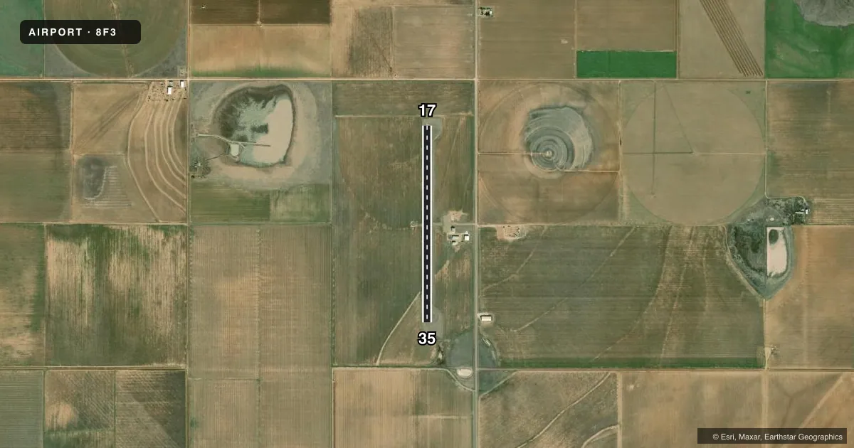
Runways & pattern
Full pagePattern entry · RWY 17
LEFT TRAFFICRunway end performance
| End | TORA | TODA | ASDA | LDA | VGSI | Approach lights | Obstruction |
|---|---|---|---|---|---|---|---|
| 17 | — | — | — | — | VASI 2-box left(4°) | — | 38', pline, 825' from thr, 275' R of cntrln, slope 16 |
| 35 | — | — | — | — | VASI 2-box left(4°) | — | 15', trees, 420' from thr, 210' R of cntrln, slope 14 |
Declared distances in feet. TORA = takeoff run available, TODA = takeoff distance, ASDA = accelerate-stop, LDA = landing distance.
Airport sketch
Runways drawn to scale from FAA survey coordinates, rendered over satellite imagery. Not for navigation.
Approaches & charts
Services on the field
Fuel grades, oxygen, maintenance, ramp storage and lighting — as declared to the FAA by the airport operator.
Fuel & services
- Fuel
- Not available
- Other services
- AGRI
Ramp & ground
- Transient storage
- Tie-down
- Landing fee
- No fee published
- Customs
- Not available
- Lighting schedule
- SEE RMK
- Beacon schedule
- SS-SR
- Beacon
- White / Green (civil land)(WG)
- Wind indicator
- Lighted
- Segmented circle
- Yes
Fuel & FBOs
Cheapest 100LL and Jet A on the field and nearby. Always confirm with the FBO before taxi.
Airport notes
Surface conditions, obstructions, local procedures, lighting outages and other notes published with each FAA cycle.
General notes
- WINDSOCK LGT OTS INDEFLY.
- FOR CD CTC FORT WORTH ARTCC AT 817-858-7584.
- SEASONAL AERIAL AG ACTVTY.
Lighting notes
- ACTVT MIRL RWY 17/35 - CTAF; OPR ON STEP 1 ONLY.
Approach & departure obstructions
- 17MARKINGS FADED, NRS MISSING.
- 35MARKINGS FADED, NRS MISSING.
- 17VASI OTS INDEFLY.
- 35VASI OTS INDEFLY.
Other notes
- MANAGERCITY/AIRPORT MGR.
VFR map & nearby airports
VFR sectional. Tap any ICAO chip to open that airport.
Key facts · 8F3
Answer card- ICAO
- 8F3
- Name
- CROSBYTON MUNI
- Location
- CROSBYTON, TEXAS
- Elevation
- 3,018.1 ft MSL
- Traffic pattern altitude
- 4,018.1 ft MSL (1,000 AGL)
- Control tower
- Non-towered (use CTAF)
- Total runways
- 1
- Longest runway
- 17/35 · 3,600 ft
- Published ILS approaches
- 0
- Published frequencies
- 6
- Magnetic variation
- 8°
- Current flight rules
- VFR
- Current wind
- 200° at 8 kt
- Favored runway now
- RWY 17
Crosbyton Muni sits in Crosbyton, Texas at 3,018.1 ft MSL. It has one runway, 17/35, which is 3,600 ft of asphalt. The field is non-towered. CTAF and UNICOM are both 122.8. No ILS approaches are published here.
The published pattern altitude is not listed. Use the standard 1,000 ft AGL pattern for light piston operations unless the current FAA Chart Supplement says otherwise. The airport is in a high-plains setting, so expect density altitude to matter on warm days. Seasonal aerial agricultural activity is published too. That means extra eyes outside the cockpit are smart.
Published remarks also note that runway lights on 17/35 are medium intensity and are activated by CTAF. They operate on step 1 only. The windsock light is out of service indefinitely. Runway 17 and runway 35 both have faded markings. The numbers are missing on both ends. The VASI on runway 17 is out of service indefinitely. The VASI on runway 35 is out of service indefinitely. No on-field FBOs are listed. Check with the airport operator or the FBO directly by phone before arrival if you need fuel or local services. For clearance delivery, contact Fort Worth ARTCC at 817-858-7584.