METAR & TAF F49
F49 does not publish a METAR.
Showing the nearest reporting station: KLBB (LUBBOCK PRESTON SMITH INTL) · 13.3 NM away. Conditions at F49 may differ.
METAR · KLBB
Observed 17:53Z
KLBB 271753Z 16011KT 10SM CLR 34/14 A3002 RMK AO2 SLP102 T03390144 10339 20228 58003
- Wind
- 160° @ 11 kt
- Visibility
- 10 SM
- Temp / Dew
- 34°C / 14°C
- Altimeter
- 30.02 inHg
- Clouds
- CLR
- Density alt
- 6,033 ft
- Ceiling
- Unlimited
- Rules
- VFR
Airport info & contacts
Manager on record, flight service, ARTCC, attendance schedule and pattern altitude — published by the FAA and refreshed every 28 days.
Location
- From city
- 2 NM N
- VFR sectional
- DALLAS-FT WORTH
- ARTCC
- ZFW · FORT WORTH
- NOTAM facility
- FTW (NOTAM-D)
Airport manager
- Name
- ROBERT NEAL
- Phone
- 806-828-5892
- Address
- 12106 FM 400, SLATON TX 79364
Flight service · Hours
- FSS FTW
- FORT WORTH1-800-WX-BRIEF
- Attendance
- MON-FRI · 0800-1700
Frequencies
Tap any row to copy the frequency to your clipboard.
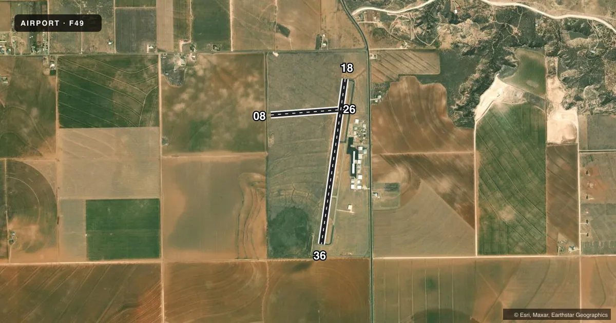
Runways & pattern
Full pagePattern entry · RWY 18
LEFT TRAFFIC| Runway | Heading (°M) | Length | Surface | Traffic |
|---|---|---|---|---|
| 18/36Favored | 182° / 2° | 4,244 ft | ASPH | Standard L |
| 08/26 | 80° / 260° | 1,720 ft | TURF | Standard L |
Runway end performance
| End | TORA | TODA | ASDA | LDA | VGSI | Approach lights | Obstruction |
|---|---|---|---|---|---|---|---|
| 18 | — | — | — | — | PAPI 2-box left(3°) | — | 23', pole, 762' from thr, 258' R of cntrln, slope 24 |
| 36 | — | — | — | — | PAPI 2-box left(3°) | — | — |
| 08 | — | — | — | — | — | — | 6', brush, 57' from thr, 0' R of cntrln, slope 9 |
Declared distances in feet. TORA = takeoff run available, TODA = takeoff distance, ASDA = accelerate-stop, LDA = landing distance.
Airport sketch
Runways drawn to scale from FAA survey coordinates, rendered over satellite imagery. Not for navigation.
Approaches & charts
Services on the field
Fuel grades, oxygen, maintenance, ramp storage and lighting — as declared to the FAA by the airport operator.
Fuel & services
- Fuel
- 100LLA
- Airframe repair
- Minor
- Power plant repair
- Minor
- Other services
- AGRI,INSTR
Ramp & ground
- Transient storage
- Tie-down
- Hangar
- Landing fee
- No fee published
- Customs
- Not available
- Lighting schedule
- SEE RMK
- Beacon schedule
- SS-SR
- Beacon
- White / Green (civil land)(WG)
- Wind indicator
- Lighted
- Segmented circle
- Yes
Fuel & FBOs
Cheapest 100LL and Jet A on the field and nearby. Always confirm with the FBO before taxi.
Airport notes
Surface conditions, obstructions, local procedures, lighting outages and other notes published with each FAA cycle.
General notes
- ACFT NOT VSB FM OPPSITE ENDS OF RWY.
- AEROBATIC ACTVT SR-SS, MOD USE ON WKENDS.
- FOR CD CTC FORT WORTH ARTCC AT 817-858-7584.
- 3457 FT MSL, 348 FT AGL TWR, 1.75 NM SW OF ARPT.
- RWY 08/26 CLSD PERMLY.
Lighting notes
- MIRL RWY 18/36 NONSTD PCL: 3-X ON, 5-X OFF - CTAF.
Approach & departure obstructions
- 18PAPI OTS INDEFLY.
- 36PAPI OTS INDEFLY.
Other notes
- MANAGERF.B.O. LESEE.
- 08/26RWY SFC ROUGH.
VFR map & nearby airports
VFR sectional. Tap any ICAO chip to open that airport.
Key facts · F49
Answer card- ICAO
- F49
- Name
- CITY OF SLATON/LARRY T NEAL MEML
- Location
- SLATON, TEXAS
- Elevation
- 3,126.5 ft MSL
- Traffic pattern altitude
- 4,126.5 ft MSL (1,000 AGL)
- Control tower
- Non-towered (use CTAF)
- Total runways
- 2
- Longest runway
- 18/36 · 4,244 ft
- Published ILS approaches
- 0
- Published frequencies
- 4
- Magnetic variation
- 6°
- Current flight rules
- VFR
- Current wind
- 160° at 11 kt
- Favored runway now
- RWY 18
City of Slaton/Larry T Neal Meml is in Slaton, Texas. The field elevation is 3,126.5 ft MSL. It has two runways, but runway 08/26 is permanently closed. The active runway is 18/36 at 4,244 ft, which is the longest runway on the field. There is no control tower. The published CTAF and UNICOM are both 123.0. Approach and departure support is through Lubbock on 119.2 and 351.8.
No ILS approaches are published here. Pattern altitude is not published, so use standard traffic pattern planning unless the current Chart Supplement says otherwise. The airport sits in west Texas at a fairly high elevation, so density altitude can matter on warm days. That affects takeoff roll and climb performance.
Neal Aircraft is on the field. It carries 100LL and Jet A Prist. The published remarks also note aerobatic activity from sunrise to sunset with moderate weekend use. Runway 18/36 has medium intensity lights with nonstandard pilot-controlled lighting on the CTAF. The PAPI is out of service on both runway ends, so plan your glidepath without it. Aircraft are not visible from opposite ends of the runway, so keep a close scan on the runway environment during taxi and departure.