METAR & TAF KLBB
Current METAR
Observed 17:53Z
KLBB 271753Z 16011KT 10SM CLR 34/14 A3002 RMK AO2 SLP102 T03390144 10339 20228 58003
- Wind
- 160° @ 11 kt
- Visibility
- 10 SM
- Temp / Dew
- 34°C / 14°C
- Altimeter
- 30.02 inHg
- Clouds
- CLR
- Density alt
- 6,226 ft
- Ceiling
- Unlimited
- Rules
- VFR
Airport info & contacts
Manager on record, flight service, ARTCC, attendance schedule and pattern altitude — published by the FAA and refreshed every 28 days.
Location
- From city
- 4 NM N
- VFR sectional
- DALLAS-FT WORTH
- ARTCC
- ZFW · FORT WORTH
- NOTAM facility
- LBB (NOTAM-D)
Airport manager
- Name
- KELLY CAMPBELL
- Phone
- 806-775-3126
- Address
- RT 3 BOX 389, LUBBOCK TX 79401
Flight service · Hours
- FSS FTW
- FORT WORTH1-800-WX-BRIEF
- Attendance
- ALL
Frequencies
Tap any row to copy the frequency to your clipboard.
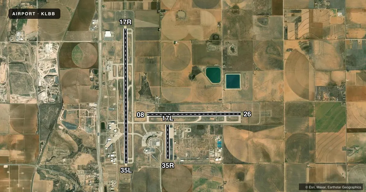
Runways & pattern
Full pagePattern entry · RWY 17R
RIGHT TRAFFIC| Runway | Heading (°M) | Length | Surface | Traffic |
|---|---|---|---|---|
| 17R/35LFavored | 174° / 354° | 11,500 ft | CONC | 17R R |
| 08/26 | 83° / 263° | 8,003 ft | CONC | 08 R |
| 17L/35R | 174° / 354° | 2,891 ft | ASPH | 35R R |
Runway end performance
| End | TORA | TODA | ASDA | LDA | VGSI | Approach lights | Obstruction |
|---|---|---|---|---|---|---|---|
| 17R | 11,500' | 11,500' | 11,500' | 11,500' | PAPI 4-box right(3°) | MALSR | — |
| 35L | 11,500' | 11,500' | 11,500' | 11,500' | VASI 4-box left(3°) | — | — |
| 08 | 8,003' | 8,003' | 8,003' | 8,003' | PAPI 4-box left(3°) | — | — |
| 26 | 8,003' | 8,003' | 8,003' | 8,003' | PAPI 4-box left(3°) | MALSR | — |
| 17L | 2,891' | 2,891' | 2,891' | 2,891' | — | — | — |
| 35R | 2,891' | 2,891' | 2,891' | 2,891' | — | — | 18', road, 573' from thr, 162' R of cntrln, slope 20 |
Declared distances in feet. TORA = takeoff run available, TODA = takeoff distance, ASDA = accelerate-stop, LDA = landing distance.
Airport sketch
Runways drawn to scale from FAA survey coordinates, rendered over satellite imagery. Not for navigation.
Approaches & charts
ILS · 2
Services on the field
Fuel grades, oxygen, maintenance, ramp storage and lighting — as declared to the FAA by the airport operator.
Fuel & services
- Fuel
- 100LLAA1+
- Oxygen (bottled)
- HIGH/LOW
- Oxygen (bulk)
- HIGH/LOW
- Airframe repair
- Major
- Power plant repair
- Major
- Other services
- AFRT,AMB,AVNCS,CHTR,INSTR,SALES
Ramp & ground
- Transient storage
- Tie-down
- Hangar
- Landing fee
- No fee published
- Customs
- Not available
- Lighting schedule
- SS-SR
- Beacon schedule
- SS-SR
- Beacon
- White / Green (civil land)(WG)
- Wind indicator
- Lighted
- Segmented circle
- No
Fuel & FBOs
Cheapest 100LL and Jet A on the field and nearby. Always confirm with the FBO before taxi.
Airport notes
Surface conditions, obstructions, local procedures, lighting outages and other notes published with each FAA cycle.
General notes
- RWY 17L/35R RSTRD TO GEN AVN ACFT 12500 LBS OR LESS.
- TWYS B & D; TXLS E & E1 RSTRD TO ACFT WEIGHING LESS THAN 50000 LBS.
- PSGR TRML RAMP ACES RSTRD TO ACRS & OTRS WITH PRIOR PMSN, CALL 806-775-2044.
- RWY 17L/35R; TWYS B & D; TXLS E & E1 NOT AVBL FOR ACR ACFT WITH OVER 9 PSGR SEATS.
- NMRS BIRDS ON & INVOF ARPT.
- EAST RAMP DELINEATED TXL & APRON AREA RSTRD TO 120000 LBS DUAL TAND ACFT; 89000 LBS DUAL SNGL WHEEL ACFT; 60000 LBS SNGL WHEEL ACFT. ALL OTR EAST RAMP PAVEMENTS RSTRD TO ACFT LESS THAN 12500 LBS SNGL WHEEL ACFT.
- PAEW ADJ RWYS 08/26 & 17R/35L.
- TWY L BTN TWY F AND TWY J CLSD TO MORE THAN 120001 LB.
- TWYS B & D, TXLS E & E1 NOT AVBL FOR PART 121/PART 380 OPS WITH SKED PAX CARRYING OPS MORE THAN 9 PAX SEATS AND NON SKED PAX CARRYING OPS MORE THAN 30 PAX SEATS.
Runway surface & condition
- 08/26PCR VALUE: 1073/R/B/W/T
- 17R/35LPCR VALUE: 965/R/B/W/T
- 17L/35RRWY 17L/35R NOT AVBL FOR PART 121/PART 380 OPS WITH SKED PAX CARRYING OPS MORE THAN 9 PAX SEATS AND NON-SKED PAX CARRYING OPS MORE THAN 30 PAX SEATS.
VFR map & nearby airports
VFR sectional. Tap any ICAO chip to open that airport.
Key facts · KLBB
Answer card- ICAO
- KLBB
- Name
- LUBBOCK PRESTON SMITH INTL
- Location
- LUBBOCK, TEXAS
- Elevation
- 3,282.4 ft MSL
- Traffic pattern altitude
- 4,282.4 ft MSL (1,000 AGL)
- Control tower
- Towered · 24
- Total runways
- 3
- Longest runway
- 17R/35L · 11,500 ft
- Published ILS approaches
- 2
- Published frequencies
- 19
- Magnetic variation
- 6°
- Current flight rules
- VFR
- Current wind
- 160° at 11 kt
- Favored runway now
- RWY 17R
Lubbock Preston Smith Intl sits in Lubbock, Texas. The field elevation is 3,282.4 ft MSL. It has 3 runways. The longest is 17R/35L at 11,500 ft. The airport has a control tower. Tower service is 24 hours. Two ILS approaches are published. They serve runway ends 17R and 26.
Pattern altitude is not published in the facts. Use the current FAA Chart Supplement before you fly. The airport is in Class C airspace. That matters for arrival planning, radio work and sequencing with the tower. Expect a busy environment for a regional airport of this size. The field elevation is high enough that density altitude can matter on warm Texas days. Performance planning should be part of the brief.
Million Air Lubbock is on the field. It carries 100LL, Jet A and Jet A Prist. The published remarks also note numerous birds on and near the airport. That is worth keeping in mind on taxi, departure and approach. Passenger terminal ramp access is restricted and requires prior permission. Call the airport at 806-775-2044 if you need that area. Runway 17L/35R is limited to general aviation aircraft 12,500 pounds or less. Taxiway and ramp weight limits also apply. Verify your route before taxiing.