METAR & TAF KPVW
Current METAR
Observed 13:10Z
KPVW 271310Z AUTO 21009KT 10SM CLR 24/15 A3003 RMK AO2 T02400148
- Wind
- 210° @ 9 kt
- Visibility
- 10 SM
- Temp / Dew
- 24°C / 15°C
- Altimeter
- 30.03 inHg
- Clouds
- CLR
- Density alt
- 5,127 ft
- Ceiling
- Unlimited
- Rules
- VFR
Airport info & contacts
Manager on record, flight service, ARTCC, attendance schedule and pattern altitude — published by the FAA and refreshed every 28 days.
Location
- From city
- 1 NM S
- VFR sectional
- DALLAS-FT WORTH
- ARTCC
- ZFW · FORT WORTH
- NOTAM facility
- PVW (NOTAM-D)
Airport manager
- Name
- RYAN STEVENSON
- Phone
- 806-293-4121
- Address
- 10 MILLER BLVD, PLAINVIEW TX 79072-1600
Flight service · Hours
- FSS FTW
- FORT WORTH1-800-WX-BRIEF
- Attendance
- 0800-1800
Frequencies
Tap any row to copy the frequency to your clipboard.
Runways & pattern
Full pagePattern entry · RWY 22
LEFT TRAFFIC| Runway | Heading (°M) | Length | Surface | Traffic |
|---|---|---|---|---|
| 04/22Favored | 42° / 222° | 5,997 ft | ASPH | Standard L |
| 13/31 | 129° / 309° | 4,000 ft | ASPH | Standard L |
Runway end performance
| End | TORA | TODA | ASDA | LDA | VGSI | Approach lights | Obstruction |
|---|---|---|---|---|---|---|---|
| 04 | — | — | — | — | VASI 4-box left(3.5°) | — | 44', pole, 2073' from thr, 0' R of cntrln, slope 42 |
| 22 | — | — | — | — | VASI 4-box left(3.5°) | — | 190', bldg, 6200' from thr, 800' R of cntrln, slope 31 |
| 13 | — | — | — | — | — | — | 40', pline, 1120' from thr, 205' R of cntrln, slope 23 |
| 31 | — | — | — | — | — | — | 15', road, 585' from thr, 172' R of cntrln, slope 25 |
Declared distances in feet. TORA = takeoff run available, TODA = takeoff distance, ASDA = accelerate-stop, LDA = landing distance.
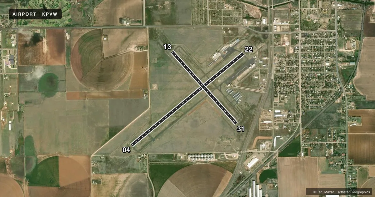
Airport sketch
Runways drawn to scale from FAA survey coordinates, rendered over satellite imagery. Not for navigation.
Approaches & charts
Services on the field
Fuel grades, oxygen, maintenance, ramp storage and lighting — as declared to the FAA by the airport operator.
Fuel & services
- Fuel
- 100LLA1+
- Airframe repair
- Not available
- Power plant repair
- Not available
- Other services
- INSTR
Ramp & ground
- Transient storage
- Tie-down
- Hangar
- Landing fee
- No fee published
- Customs
- Not available
- Lighting schedule
- SEE RMK
- Beacon schedule
- SS-SR
- Beacon
- White / Green (civil land)(WG)
- Wind indicator
- Lighted
- Segmented circle
- Yes
Fuel & FBOs
Cheapest 100LL and Jet A on the field and nearby. Always confirm with the FBO before taxi.
Airport notes
Surface conditions, obstructions, local procedures, lighting outages and other notes published with each FAA cycle.
General notes
- NO LINE OF SIGHT TO RWY 13/31 FM RWY END 22.
- FOR CD IF UNA TO CTC ON FSS FREQ, CTC FORT WORTH ARTCC AT 817-858-7584.
Lighting notes
- MIRL RWY 4/22, RWY 13/31 SS-SR, PRESET LOW INTST. TO INCR INTST AND ACTVT REIL RWY 4; VASI RWY 22 - CTAF. VASI RWY 4 OPR CONSLY.
Approach & departure obstructions
- 04UNUSBL BYD 7 DEG LEFT OF RWY CNTRLN.
- 22GRAIN ELEVATOR
Other notes
- THIS AIRPORT HAS BEEN SURVEYED BY THE NATIONAL GEODETIC SURVEY.
- 1UNATNDD THANKSGIVING & CHRISTMAS.
- 04/22TRANSVERSE AND LONGL CRACKS UP TO 4 IN WID, FULL LEN.
VFR map & nearby airports
VFR sectional. Tap any ICAO chip to open that airport.
Key facts · KPVW
Answer card- ICAO
- KPVW
- Name
- HALE COUNTY
- Location
- PLAINVIEW, TEXAS
- Elevation
- 3,374 ft MSL
- Traffic pattern altitude
- 4,374 ft MSL (1,000 AGL)
- Control tower
- Non-towered (use CTAF)
- Total runways
- 2
- Longest runway
- 04/22 · 5,997 ft
- Published ILS approaches
- 0
- Published frequencies
- 7
- Magnetic variation
- 9°
- Current flight rules
- VFR
- Current wind
- 210° at 9 kt
- Favored runway now
- RWY 22
Hale County Airport sits in Plainview, Texas. The field elevation is 3,374 ft MSL. It has two asphalt runways. The longest is runway 04/22 at 5,997 ft. Runway 13/31 is 4,000 ft. There is no control tower. CTAF and UNICOM are both 123.0. No ILS approaches are published here.
Pattern altitude is not published. Use the standard 1,000 ft AGL for light piston traffic unless the current Chart Supplement says otherwise. That puts the usual pattern reference at 4,374 ft MSL. The airport sits in open country at a higher elevation, so density altitude can matter on warm days. Plan performance with that in mind.
Tradewind Aviation is the on-field FBO. It carries 100LL and Jet A. Runway 04/22 has reported cracking along the full length. The published remarks also note a grain elevator near runway end 22. Runway lights are medium intensity on both runways from sunset to sunrise. They start at low intensity. Use CTAF to increase intensity on runway 04 and to activate the runway end identifier lights. The VASI on runway 22 is controlled by CTAF. The airport is unattended on Thanksgiving and Christmas. For clearance delivery issues, Fort Worth ARTCC is listed as a backup contact.