METAR & TAF KLIU
KLIU does not publish a METAR.
Showing the nearest reporting station: KLLN (LEVELLAND MUNI) · 22.3 NM away. Conditions at KLIU may differ.
METAR · KLLN
Observed 18:15Z
KLLN 271815Z AUTO 13012KT 10SM CLR 34/14 A3003 RMK AO2
- Wind
- 130° @ 12 kt
- Visibility
- 10 SM
- Temp / Dew
- 34°C / 14°C
- Altimeter
- 30.03 inHg
- Clouds
- CLR
- Density alt
- 6,627 ft
- Ceiling
- Unlimited
- Rules
- VFR
Airport info & contacts
Manager on record, flight service, ARTCC, attendance schedule and pattern altitude — published by the FAA and refreshed every 28 days.
Location
- From city
- 3 NM W
- VFR sectional
- ALBUQUERQUE
- ARTCC
- ZFW · FORT WORTH
- NOTAM facility
- FTW (NOTAM-D)
Airport manager
- Name
- TOM BROWN
- Phone
- 806-777-5030
- Address
- BOX 1102, LITTLEFIELD TX 79339
Flight service · Hours
- FSS FTW
- FORT WORTH1-800-WX-BRIEF
- Attendance
- 0800-1700
Frequencies
Tap any row to copy the frequency to your clipboard.
Runways & pattern
Full pagePattern entry · RWY 13
LEFT TRAFFIC| Runway | Heading (°M) | Length | Surface | Traffic |
|---|---|---|---|---|
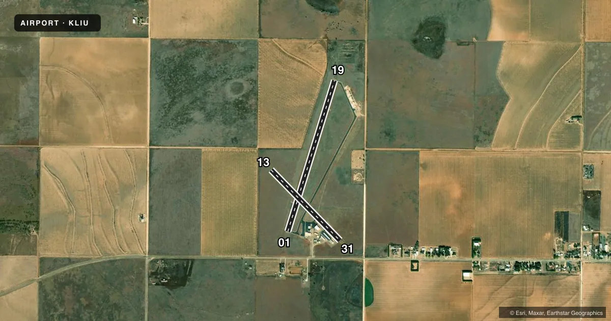
| 01/19 | 10° / 190° | 4,021 ft | ASPH | Standard L |
| 13/31Favored | 129° / 309° | 2,513 ft | ASPH | Standard L |
Runway end performance
| End | TORA | TODA | ASDA | LDA | VGSI | Approach lights | Obstruction |
|---|---|---|---|---|---|---|---|
| 01 | — | — | — | — | PAPI 2-box left(3°) | — | 41', tree, 865' from thr, 75' R of cntrln, slope 16 |
| 19 | — | — | — | — | PAPI 2-box left(3°) | — | 27', tree, 990' from thr, 222' R of cntrln, slope 29 |
| 13 | — | — | — | — | — | — | 8', road, 320' from thr, 137' R of cntrln, slope 15 |
| 31 | — | — | — | — | — | — | 16', pline, 620' from thr, 145' R of cntrln, slope 26 |
Declared distances in feet. TORA = takeoff run available, TODA = takeoff distance, ASDA = accelerate-stop, LDA = landing distance.
Airport sketch
Runways drawn to scale from FAA survey coordinates, rendered over satellite imagery. Not for navigation.
Approaches & charts
Services on the field
Fuel grades, oxygen, maintenance, ramp storage and lighting — as declared to the FAA by the airport operator.
Fuel & services
- Fuel
- 100LL
- Oxygen (bottled)
- Not available
- Oxygen (bulk)
- Not available
- Airframe repair
- Minor
- Power plant repair
- Minor
- Other services
- AGRI,GLD,INSTR,TOW
Ramp & ground
- Transient storage
- Tie-down
- Hangar
- Landing fee
- No fee published
- Customs
- Not available
- Lighting schedule
- SS-SR
- Beacon schedule
- SS-SR
- Beacon
- White / Green (civil land)(WG)
- Wind indicator
- Lighted
- Segmented circle
- Yes
Fuel & FBOs
Cheapest 100LL and Jet A on the field and nearby. Always confirm with the FBO before taxi.
Airport notes
Surface conditions, obstructions, local procedures, lighting outages and other notes published with each FAA cycle.
General notes
- GLIDER OPNS SR-SS WEEKENDS.
- HANGARS OBSTRUCT TRANSITIONAL SFC RWY 13/31.
- FOR CD CTC FORT WORTH ARTCC AT 817-858-7584.
Fuel notes
- 100LLFOR FUEL AFT HRS CALL 806-777-5030, 806-778-1418 OR 806-241-0761.
Other notes
- THIS AIRPORT HAS BEEN SURVEYED BY THE NATIONAL GEODETIC SURVEY.
VFR map & nearby airports
VFR sectional. Tap any ICAO chip to open that airport.
Key facts · KLIU
Answer card- ICAO
- KLIU
- Name
- LITTLEFIELD TAYLOR BROWN MUNI
- Location
- LITTLEFIELD, TEXAS
- Elevation
- 3,615.6 ft MSL
- Traffic pattern altitude
- 4,615.6 ft MSL (1,000 AGL)
- Control tower
- Non-towered (use CTAF)
- Total runways
- 2
- Longest runway
- 01/19 · 4,021 ft
- Published ILS approaches
- 0
- Published frequencies
- 6
- Magnetic variation
- 7°
- Current flight rules
- VFR
- Current wind
- 130° at 12 kt
- Favored runway now
- RWY 13
Littlefield Taylor Brown Muni sits in Littlefield, Texas at 3,615.6 ft MSL. It has two asphalt runways. The longest is 01/19 at 4,021 ft. Runway 13/31 is 2,513 ft. There is no control tower, so plan for non-towered operations on CTAF 122.8. No ILS approaches are published here, so check the current FAA Chart Supplement and your approach setup before you go.
The published pattern altitude is not listed. For light piston traffic, use the standard 1,000 ft AGL unless current published data says otherwise. That puts the pattern near 4,616 ft MSL based on the field elevation. Magnetic variation is 7°. Runway headings are 17°/197° for 01/19 and 136°/316° for 13/31.
There are no on-field FBOs listed. Fuel after hours is handled by phone per the published remarks. Glider operations run from sunrise to sunset on weekends. Hangars also obstruct the transitional surface for runway 13/31, so pay attention to that side of the field on departure and arrival. For clearance delivery, contact Fort Worth ARTCC. At this elevation, density altitude can matter a lot in warm weather, so a performance check before takeoff is a good idea.