METAR & TAF F85
F85 does not publish a METAR.
Showing the nearest reporting station: KLLN (LEVELLAND MUNI) · 21.1 NM away. Conditions at F85 may differ.
METAR · KLLN
Observed 16:35Z
KLLN 271635Z AUTO 18008G15KT 10SM CLR 31/15 A3005 RMK AO2
- Wind
- 180° @ 8G15 kt
- Visibility
- 10 SM
- Temp / Dew
- 31°C / 15°C
- Altimeter
- 30.05 inHg
- Clouds
- CLR
- Density alt
- 6,405 ft
- Ceiling
- Unlimited
- Rules
- VFR
Airport info & contacts
Manager on record, flight service, ARTCC, attendance schedule and pattern altitude — published by the FAA and refreshed every 28 days.
Location
- From city
- 2 NM E
- VFR sectional
- ALBUQUERQUE
- ARTCC
- ZFW · FORT WORTH
- NOTAM facility
- FTW (NOTAM-D)
Airport manager
- Name
- PAT HENRY
- Phone
- 806-266-5508
- Address
- COCHRAN CO COURTHOUSE ROOM 105, 101 MAIN ST TX 79346
Flight service · Hours
- FSS FTW
- FORT WORTH1-800-WX-BRIEF
- Attendance
- Unattended
Frequencies
Tap any row to copy the frequency to your clipboard.
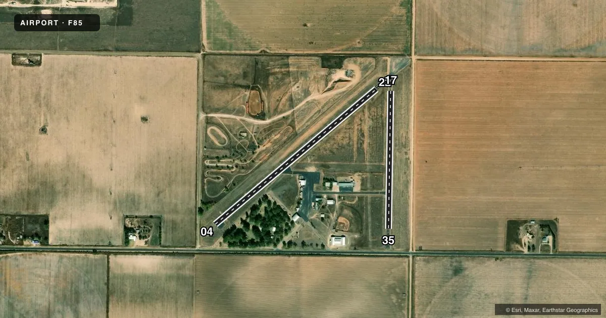
Runways & pattern
Full pagePattern entry · RWY 17
LEFT TRAFFIC| Runway | Heading (°M) | Length | Surface | Traffic |
|---|---|---|---|---|
| 04/22 | 41° / 221° | 2,710 ft | ASPH | Standard L |
| 17/35Favored | 172° / 352° | 1,775 ft | ASPH | Standard L |
Runway end performance
| End | TORA | TODA | ASDA | LDA | VGSI | Approach lights | Obstruction |
|---|---|---|---|---|---|---|---|
| 04 | — | — | — | — | — | — | 15', road, 201' from thr, 60' R of cntrln, slope 0 |
| 22 | — | — | — | — | VASI 2-box left(3°) | — | 15', road, 420' from thr, 0' R of cntrln, slope 14 |
| 35 | — | — | — | — | — | — | 15', road, 300' from thr, 0' R of cntrln, slope 6 |
Declared distances in feet. TORA = takeoff run available, TODA = takeoff distance, ASDA = accelerate-stop, LDA = landing distance.
Airport sketch
Runways drawn to scale from FAA survey coordinates, rendered over satellite imagery. Not for navigation.
Approaches & charts
Services on the field
Fuel grades, oxygen, maintenance, ramp storage and lighting — as declared to the FAA by the airport operator.
Fuel & services
- Fuel
- Not available
- Oxygen (bottled)
- Not available
- Oxygen (bulk)
- Not available
- Other services
- AGRI
Ramp & ground
- Transient storage
- Tie-down
- Landing fee
- No fee published
- Customs
- Not available
- Lighting schedule
- SS-SR
- Beacon schedule
- SS-SR
- Beacon
- White / Green (civil land)(WG)
- Wind indicator
- Lighted
- Segmented circle
- Yes
Fuel & FBOs
Cheapest 100LL and Jet A on the field and nearby. Always confirm with the FBO before taxi.
Airport notes
Surface conditions, obstructions, local procedures, lighting outages and other notes published with each FAA cycle.
General notes
- 4171 FT MSL, 399 FT AGL TWR, 1.5 NM SW.
- FOR CD CTC FORT WORTH ARTCC AT 817-858-7584.
- RWY 4/22 MIRL OTS INDFLY.
Runway surface & condition
- 17/35RWY CLSD NGT.
Approach & departure obstructions
- 0415 FT RD, 116 FT DSTC, 135 FT L.
- 04APCH RATIO 18:1 AT DSPLCD THR.
Other notes
- MANAGERCOUNTY JUDGE. EMERG CTC 806-266-5700.
- 17/35EXTSV CRACKING, VEGETATION GROWING THROUGH.
VFR map & nearby airports
VFR sectional. Tap any ICAO chip to open that airport.
Key facts · F85
Answer card- ICAO
- F85
- Name
- COCHRAN COUNTY
- Location
- MORTON, TEXAS
- Elevation
- 3,747.2 ft MSL
- Traffic pattern altitude
- 4,747.2 ft MSL (1,000 AGL)
- Control tower
- Non-towered (use CTAF)
- Total runways
- 2
- Longest runway
- 04/22 · 2,710 ft
- Published ILS approaches
- 0
- Published frequencies
- 1
- Magnetic variation
- 9°
- Current flight rules
- VFR
- Current wind
- 180° at 8 kt
- Favored runway now
- RWY 17
Cochran County Airport sits near Morton, Texas. The field elevation is 3,747.2 ft MSL. It has two asphalt runways. The longest is runway 04/22 at 2,710 ft. There is no control tower. CTAF is 122.9. No ILS approaches are published.
Pattern altitude is not published. Use 1,000 ft AGL for light piston ops unless the current Chart Supplement says otherwise. That puts the standard pattern around 4,747 ft MSL at this field. Runway 04/22 has medium intensity lights that are out of service indefinitely. Runway 17/35 is 1,775 ft long. It has extensive cracking with vegetation growing through. Runway 17/35 is also closed at night.
There are no on-field FBOs listed. Check with the airport operator or the FBO directly by phone before you go. The published remarks also note an approach slope ratio of 18 to 1 at the displaced threshold of runway 04. That matters if you are planning a low approach or a short final. This is a high-elevation airport in west Texas. Expect density altitude to matter, especially in warm weather. The airport elevation is listed as 4,171 ft MSL in the remarks. Verify the current field data and any operating limits before arrival. For clearance delivery, contact Fort Worth ARTCC at 817-858-7584.