METAR & TAF F98
F98 does not publish a METAR.
Showing the nearest reporting station: KLLN (LEVELLAND MUNI) · 30.5 NM away. Conditions at F98 may differ.
METAR · KLLN
Observed 19:15Z
KLLN 271915Z AUTO 15011KT 10SM CLR 35/12 A3002 RMK AO2
- Wind
- 150° @ 11 kt
- Visibility
- 10 SM
- Temp / Dew
- 35°C / 12°C
- Altimeter
- 30.02 inHg
- Clouds
- CLR
- Density alt
- 6,870 ft
- Ceiling
- Unlimited
- Rules
- VFR
Airport info & contacts
Manager on record, flight service, ARTCC, attendance schedule and pattern altitude — published by the FAA and refreshed every 28 days.
Location
- From city
- 1 NM NW
- VFR sectional
- ALBUQUERQUE
- ARTCC
- ZFW · FORT WORTH
- NOTAM facility
- FTW (NOTAM-D)
Airport manager
- Name
- TOMMY BOX
- Phone
- 806-592-1267
- Address
- PO BOX 456, PLAINS TX 79355
Flight service · Hours
- FSS FTW
- FORT WORTH1-800-WX-BRIEF
- Attendance
- IREG
Frequencies
Tap any row to copy the frequency to your clipboard.
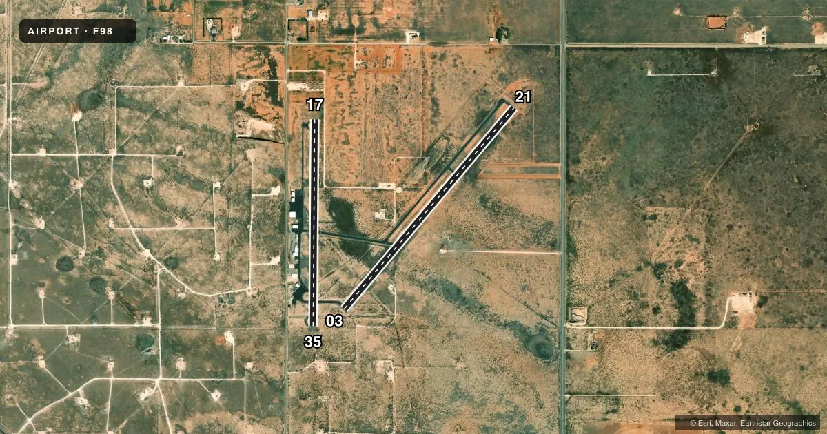
Runways & pattern
Full pagePattern entry · RWY 17
LEFT TRAFFIC| Runway | Heading (°M) | Length | Surface | Traffic |
|---|---|---|---|---|
| 03/21 | 33° / 213° | 5,001 ft | ASPH | Standard L |
| 17/35Favored | 173° / 353° | 3,924 ft | ASPH | Standard L |
Runway end performance
| End | TORA | TODA | ASDA | LDA | VGSI | Approach lights | Obstruction |
|---|---|---|---|---|---|---|---|
| 21 | — | — | — | — | — | — | 35', pole, 1521' from thr, 0' R of cntrln, slope 37 |
| 17 | — | — | — | — | — | — | 30', pole, 548' from thr, 98' R of cntrln, slope 11 |
| 35 | — | — | — | — | — | — | 25', pole, 880' from thr, 70' R of cntrln, slope 27 |
Declared distances in feet. TORA = takeoff run available, TODA = takeoff distance, ASDA = accelerate-stop, LDA = landing distance.
Airport sketch
Runways drawn to scale from FAA survey coordinates, rendered over satellite imagery. Not for navigation.
Approaches & charts
Services on the field
Fuel grades, oxygen, maintenance, ramp storage and lighting — as declared to the FAA by the airport operator.
Fuel & services
- Fuel
- 100LL
- Oxygen (bottled)
- Not available
- Oxygen (bulk)
- Not available
- Airframe repair
- Not available
- Power plant repair
- Not available
- Other services
- AGRI
Ramp & ground
- Transient storage
- Tie-down
- Hangar
- Landing fee
- No fee published
- Customs
- Not available
- Lighting schedule
- SEE RMK
- Beacon schedule
- SS-SR
- Beacon
- White / Green (civil land)(WG)
- Wind indicator
- Lighted
- Segmented circle
- Yes
Fuel & FBOs
Cheapest 100LL and Jet A on the field and nearby. Always confirm with the FBO before taxi.
Airport notes
Surface conditions, obstructions, local procedures, lighting outages and other notes published with each FAA cycle.
General notes
- FOR CD CTC FORT WORTH ARTCC AT 817-858-7584.
Lighting notes
- DUSK-DAWN. MIRL RWYS 03/21 & 17/35 PRESET LOW INTST; TO INCR INTST ACTVT - CTAF.
Fuel notes
- 100LLSELF SERVE.
Approach & departure obstructions
- 214 FT BERM 115 FT LEFT OF RWY CNTRLN AT THR, 3-4 FT SCATTERED BRUSH 0-200 FT FM THR ACRS APCH.
Other notes
- MANAGERTBOX@YOAKUMCOUNTY.ORG
VFR map & nearby airports
VFR sectional. Tap any ICAO chip to open that airport.
Key facts · F98
Answer card- ICAO
- F98
- Name
- YOAKUM COUNTY
- Location
- PLAINS, TEXAS
- Elevation
- 3,705 ft MSL
- Traffic pattern altitude
- 4,705 ft MSL (1,000 AGL)
- Control tower
- Non-towered (use CTAF)
- Total runways
- 2
- Longest runway
- 03/21 · 5,001 ft
- Published ILS approaches
- 0
- Published frequencies
- 1
- Magnetic variation
- 7°
- Current flight rules
- VFR
- Current wind
- 150° at 11 kt
- Favored runway now
- RWY 17
Yoakum County Airport sits in Plains, Texas. Field elevation is 3,705 ft MSL. The airport has two asphalt runways. Runway 03/21 is the longest at 5,001 ft. Runway 17/35 is 3,924 ft. There is no control tower. CTAF is 122.9.
No ILS approaches are published here. Pattern altitude is not published, so use standard 1,000 ft AGL for light piston operations unless the current Chart Supplement says otherwise. The field is in west Texas at a fairly high elevation. That means density altitude can matter on warm days. Plan performance with that in mind.
Sandy Land UWCD is on the field. It carries 100LL. The fuel is self-serve. Runway lighting is available from dusk to dawn. The medium intensity lights on both runways start at low intensity. Key the CTAF to bring them up if needed. There is also a published obstruction note for runway 21. A berm sits left of the centerline near the threshold. Brush is also reported near the approach end. If you are new to the airport, brief that arrival carefully and check the current Chart Supplement before you go.