METAR & TAF KGNC
Current METAR
Observed 20:15Z
KGNC 272015Z AUTO 14006G14KT 10SM CLR 38/12 A3001 RMK AO2 T03800118
- Wind
- 140° @ 6G14 kt
- Visibility
- 10 SM
- Temp / Dew
- 38°C / 12°C
- Altimeter
- 30.01 inHg
- Clouds
- CLR
- Density alt
- 6,759 ft
- Ceiling
- Unlimited
- Rules
- VFR
Airport info & contacts
Manager on record, flight service, ARTCC, attendance schedule and pattern altitude — published by the FAA and refreshed every 28 days.
Location
- From city
- 3 NM S
- VFR sectional
- ALBUQUERQUE
- ARTCC
- ZFW · FORT WORTH
- NOTAM facility
- GNC (NOTAM-D)
Airport manager
- Name
- DAVID MURPHREE
- Phone
- 432-788-7657
- Address
- P O BOX 847, SEMINOLE TX 79360
Flight service · Hours
- FSS FTW
- FORT WORTH1-800-WX-BRIEF
- Attendance
- MON-FRI · 0800-1800
- SAT · 0800-1200
Frequencies
Tap any row to copy the frequency to your clipboard.
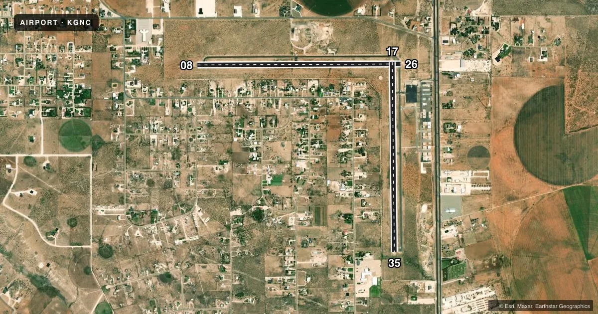
Runways & pattern
Full pagePattern entry · RWY 17
LEFT TRAFFIC| Runway | Heading (°M) | Length | Surface | Traffic |
|---|---|---|---|---|
| 08/26 | 81° / 261° | 5,381 ft | ASPH | Standard L |
| 17/35Favored | 170° / 350° | 5,002 ft | ASPH | Standard L |
Runway end performance
| End | TORA | TODA | ASDA | LDA | VGSI | Approach lights | Obstruction |
|---|---|---|---|---|---|---|---|
| 08 | — | — | — | — | PAPI 2-box left(3°) | — | — |
| 26 | — | — | — | — | PAPI 2-box left(3°) | — | 30', pline, 848' from thr, 0' R of cntrln, slope 21 |
| 17 | — | — | — | — | PAPI 2-box left(3°) | — | 30', pline, 1200' from thr, 265' R of cntrln, slope 33 |
| 35 | — | — | — | — | PAPI 2-box left(3°) | — | — |
Declared distances in feet. TORA = takeoff run available, TODA = takeoff distance, ASDA = accelerate-stop, LDA = landing distance.
Airport sketch
Runways drawn to scale from FAA survey coordinates, rendered over satellite imagery. Not for navigation.
Approaches & charts
Services on the field
Fuel grades, oxygen, maintenance, ramp storage and lighting — as declared to the FAA by the airport operator.
Fuel & services
- Fuel
- 100LLA
- Oxygen (bottled)
- High pressure
- Oxygen (bulk)
- High pressure
- Airframe repair
- Major
- Power plant repair
- Major
- Other services
- INSTR,RNTL
Ramp & ground
- Transient storage
- Tie-down
- Hangar
- Landing fee
- No fee published
- Lighting schedule
- SEE RMK
- Beacon schedule
- SS-SR
- Beacon
- White / Green (civil land)(WG)
- Wind indicator
- Lighted
- Segmented circle
- Yes
Fuel & FBOs
Cheapest 100LL and Jet A on the field and nearby. Always confirm with the FBO before taxi.
Airport notes
Surface conditions, obstructions, local procedures, lighting outages and other notes published with each FAA cycle.
General notes
- FOR CD CTC FORT WORTH ARTCC AT 817-858-7584.
Lighting notes
- MIRL RWYS 08/26 & 17/35 PRESET LOW INTST; TO INCR INTST ACTVT - CTAF.
Approach & departure obstructions
- 08RWY MRKGS FADED.
- 26RWY MRKGS FADED.
- 17169 FT ANT 410 FT RIGHT OF CNTRLN.
Other notes
- THIS AIRPORT HAS BEEN SURVEYED BY THE NATIONAL GEODETIC SURVEY.
- 1AFT HRS SVC: EMAIL JONATHAN OR CALL 432-955-7672.
- MANAGERCOUNTY COMMISSIONER
- ON SITEJONATHAN@FLYTEXAVIATION.COM
VFR map & nearby airports
VFR sectional. Tap any ICAO chip to open that airport.
Key facts · KGNC
Answer card- ICAO
- KGNC
- Name
- GAINES COUNTY
- Location
- SEMINOLE, TEXAS
- Elevation
- 3,314.9 ft MSL
- Traffic pattern altitude
- 4,314.9 ft MSL (1,000 AGL)
- Control tower
- Non-towered (use CTAF)
- Total runways
- 2
- Longest runway
- 08/26 · 5,381 ft
- Published ILS approaches
- 0
- Published frequencies
- 2
- Magnetic variation
- 9°
- Current flight rules
- VFR
- Current wind
- 140° at 6 kt
- Favored runway now
- RWY 17
Gaines County Airport sits near Seminole, Texas. Field elevation is 3,314.9 ft MSL. The airport has two asphalt runways. The longest is 5,381 ft on runway 08/26. There is no control tower. CTAF and UNICOM are both 122.8. No ILS approaches are published, so plan with the current chart and the weather you actually have.
Pattern altitude is not published. Use 1,000 ft AGL as the standard light-piston pattern unless local procedures or ATC say otherwise. That puts the pattern at about 4,315 ft MSL here. The published remarks matter. Runway markings on 08 and 26 are faded. Runway 17 has a 169 ft antenna about 410 ft right of centerline. The medium intensity runway lights on both runways are preset to low intensity. Use the CTAF to step them up at night.
FlyTex Aviation is on the field. It carries 100LL and Jet A. For clearance delivery, contact Fort Worth ARTCC at 817-858-7584. This is a high-elevation field in west Texas. Expect density altitude to matter on warm days. Check performance before departure. If you need after-hours help, use the published email contact or call 432-955-7672.