METAR & TAF E11
Current METAR
Observed 20:15Z
KE11 272015Z AUTO 10008G15KT 10SM CLR 37/12 A2998 RMK AO2 T03730120
- Wind
- 100° @ 8G15 kt
- Visibility
- 10 SM
- Temp / Dew
- 37°C / 12°C
- Altimeter
- 29.98 inHg
- Clouds
- CLR
- Density alt
- 6,501 ft
- Ceiling
- Unlimited
- Rules
- VFR
Airport info & contacts
Manager on record, flight service, ARTCC, attendance schedule and pattern altitude — published by the FAA and refreshed every 28 days.
Location
- From city
- 1 NM NE
- VFR sectional
- ALBUQUERQUE
- ARTCC
- ZFW · FORT WORTH
- NOTAM facility
- SJT (NOTAM-D)
Airport manager
- Name
- ANDREW WHITE
- Phone
- 432-524-1447
- Address
- 853 E. BROADWAY, ANDREWS TX 79714
Flight service · Hours
- FSS SJT
- SAN ANGELO1-800-WX-BRIEF
- Attendance
- MON-FRI · 0800-1700
Frequencies
Tap any row to copy the frequency to your clipboard.
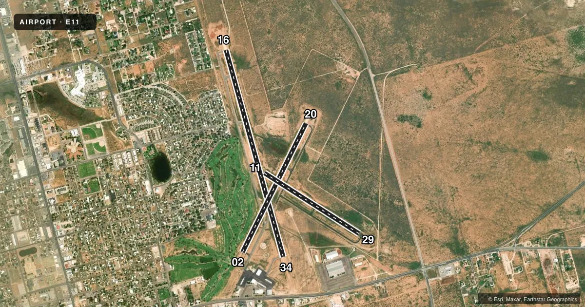
Runways & pattern
Full pagePattern entry · RWY 11
LEFT TRAFFIC| Runway | Heading (°M) | Length | Surface | Traffic |
|---|---|---|---|---|
| 16/34 | 155° / 335° | 5,816 ft | ASPH | 34 R |
| 02/20 | 17° / 197° | 3,893 ft | ASPH | 02 R |
| 11/29Favored | 114° / 294° | 3,048 ft | ASPH | 29 R |
Runway end performance
| End | TORA | TODA | ASDA | LDA | VGSI | Approach lights | Obstruction |
|---|---|---|---|---|---|---|---|
| 16 | — | — | — | — | PAPI 4-box left(3°) | — | 64', tree, 1200' from thr, 542' R of cntrln, slope 15 |
| 34 | — | — | — | — | PAPI 4-box left(3°) | — | 46', trees, 1190' from thr, 126' R of cntrln, slope 21 |
| 02 | — | — | — | — | PAPI 2-box left(3°) | — | 55', trees, 285' from thr, 138' R of cntrln, slope 1 |
| 20 | — | — | — | — | PAPI 2-box left(3°) | — | 10', gnd, 514' from thr, 125' R of cntrln, slope 31 |
| 11 | — | — | — | — | — | — | 55', trees, 940' from thr, 130' R of cntrln, slope 13 |
| 29 | — | — | — | — | — | — | 45', pole, 1830' from thr, 125' R of cntrln, slope 36 |
Declared distances in feet. TORA = takeoff run available, TODA = takeoff distance, ASDA = accelerate-stop, LDA = landing distance.
Airport sketch
Runways drawn to scale from FAA survey coordinates, rendered over satellite imagery. Not for navigation.
Approaches & charts
Services on the field
Fuel grades, oxygen, maintenance, ramp storage and lighting — as declared to the FAA by the airport operator.
Fuel & services
- Fuel
- 100LLA
- Airframe repair
- Minor
- Power plant repair
- Minor
Ramp & ground
- Transient storage
- Tie-down
- Landing fee
- No fee published
- Customs
- Not available
- Lighting schedule
- SEE RMK
- Beacon schedule
- SS-SR
- Beacon
- White / Green (civil land)(WG)
- Wind indicator
- Lighted
- Segmented circle
- Yes
Fuel & FBOs
Cheapest 100LL and Jet A on the field and nearby. Always confirm with the FBO before taxi.
Airport notes
Surface conditions, obstructions, local procedures, lighting outages and other notes published with each FAA cycle.
General notes
- FOR CD CTC MIDLAND APCH AT 432-563-2123. WHEN APCH CLSD CTC FORT WORTH ARTCC AT 817-858-7584.
Lighting notes
- ACTVT REIL RWYS 16 & 34; PAPI RWYS 02 & 20; MIRL RWYS 02/20 & 16/34 - CTAF.
Approach & departure obstructions
- 022 FT. POSTS/CABLE FENCE.
- 02RWY 02 APCH SLOPE 14:1 AT DSPLCD THR OVR 55 FT TREE, 822 FT DSTC, 205 FT L.
- H160 FT RTG BCN 172 FT EAST (80 DEG).
VFR map & nearby airports
VFR sectional. Tap any ICAO chip to open that airport.
Key facts · E11
Answer card- ICAO
- E11
- Name
- ANDREWS COUNTY
- Location
- ANDREWS, TEXAS
- Elevation
- 3,174 ft MSL
- Traffic pattern altitude
- 4,174 ft MSL (1,000 AGL)
- Control tower
- Non-towered (use CTAF)
- Total runways
- 3
- Longest runway
- 16/34 · 5,816 ft
- Published ILS approaches
- 0
- Published frequencies
- 4
- Magnetic variation
- 9°
- Current flight rules
- VFR
- Current wind
- 100° at 8 kt
- Favored runway now
- RWY 11
Andrews County Airport is in Andrews, Texas. Field elevation is 3,174 ft MSL. The airport has three asphalt runways. The longest is 5,816 ft on runway 16/34. There is no control tower, so use CTAF 122.8 for local traffic calls. No ILS approaches are published here.
Pattern altitude is not published. For a light piston, use the standard 1,000 ft AGL unless local procedures say otherwise. The field sits in west Texas at a fairly high elevation, so expect performance planning to matter on warm days. Runway 16 and runway 34 have runway end identifier lights. Runways 02 and 20 have PAPI. Runways 02/20 and 16/34 have medium intensity runway lighting.
Andrews County Airport is the on-field FBO. It carries 100LL and Jet A. For clearance delivery, contact Midland Approach. When Midland Approach is closed, contact Fort Worth ARTCC. Runway 02 has published obstruction notes. There is a tree near the approach path, plus posts and a cable fence near the runway. If you are planning a first arrival, review the current FAA Chart Supplement before you go. That is the best place to confirm any local procedures and to check the latest operational notes.