METAR & TAF 7T7
7T7 does not publish a METAR.
Showing the nearest reporting station: KMAF (MIDLAND INTL AIR AND SPACE PORT) · 8.4 NM away. Conditions at 7T7 may differ.
METAR · KMAF
Observed 16:53Z
KMAF 271653Z 17011KT 9SM CLR 33/17 A2999 RMK AO2 SLP101 T03280167 $
- Wind
- 170° @ 11 kt
- Visibility
- 9 SM
- Temp / Dew
- 33°C / 17°C
- Altimeter
- 29.99 inHg
- Clouds
- CLR
- Density alt
- 5,551 ft
- Ceiling
- Unlimited
- Rules
- VFR
Airport info & contacts
Manager on record, flight service, ARTCC, attendance schedule and pattern altitude — published by the FAA and refreshed every 28 days.
Location
- From city
- 9 NM S
- VFR sectional
- SAN ANTONIO
- ARTCC
- ZFW · FORT WORTH
- NOTAM facility
- SJT (NOTAM-D)
Airport manager
- Name
- AARON KINSEY
- Phone
- 432-682-5055
- Address
- 10306 S CR 1210, MIDLAND TX 79706
Flight service · Hours
- FSS SJT
- SAN ANGELO1-800-WX-BRIEF
- Attendance
- DAWN-DUSK
Frequencies
Tap any row to copy the frequency to your clipboard.
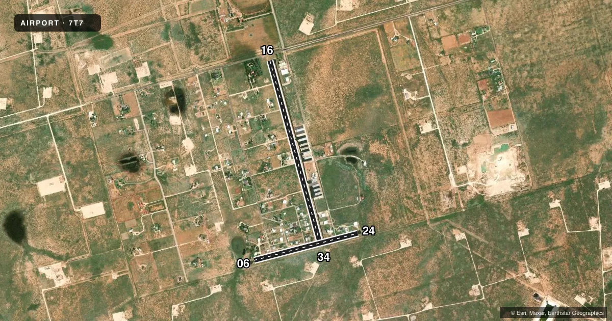
Runways & pattern
Full pagePattern entry · RWY 16
LEFT TRAFFIC| Runway | Heading (°M) | Length | Surface | Traffic |
|---|---|---|---|---|
| 16/34Favored | 156° / 336° | 5,000 ft | ASPH | Standard L |
| 06/24 | 66° / 246° | 2,800 ft | ASPH | Standard L |
Runway end performance
| End | TORA | TODA | ASDA | LDA | VGSI | Approach lights | Obstruction |
|---|---|---|---|---|---|---|---|
| 16 | — | — | — | — | — | — | 10', fence, 201' from thr, 125' R of cntrln, slope 0 |
| 34 | — | — | — | — | — | — | 8', fence, 277' from thr, 120' R of cntrln, slope 9 |
| 06 | — | — | — | — | — | — | 5', brush, 201' from thr, 125' R of cntrln, slope 0 |
| 24 | — | — | — | — | — | — | 6', brush, 201' from thr, 125' R of cntrln, slope 0 |
Declared distances in feet. TORA = takeoff run available, TODA = takeoff distance, ASDA = accelerate-stop, LDA = landing distance.
Airport sketch
Runways drawn to scale from FAA survey coordinates, rendered over satellite imagery. Not for navigation.
Approaches & charts
Services on the field
Fuel grades, oxygen, maintenance, ramp storage and lighting — as declared to the FAA by the airport operator.
Fuel & services
- Fuel
- 100LLMOGAS
- Airframe repair
- Minor
- Power plant repair
- Major
- Other services
- INSTR,SALES
Ramp & ground
- Transient storage
- Tie-down
- Hangar
- Landing fee
- No fee published
- Lighting schedule
- SS-SR
- Wind indicator
- Yes
- Segmented circle
- Yes
Fuel & FBOs
Cheapest 100LL and Jet A on the field and nearby. Always confirm with the FBO before taxi.
Airport notes
Surface conditions, obstructions, local procedures, lighting outages and other notes published with each FAA cycle.
General notes
- DEER ON & INVOF ARPT.
- FOR CD CTC MIDLAND APCH AT 432-563-2123. WHEN APCH CLSD CTC FORT WORTH ARTCC AT 817-858-7584.
Fuel notes
- 100LLFUEL IS SELF SERVE.
Runway surface & condition
- 16/34NSTD SOLAR LIGHTS, 4 CLEAR LGTS EACH END.
Approach & departure obstructions
- 065 FT FENCE, 0-199 FT DSTC, 70 FT L/R.
- 167 FT FENCE 140 FT DSTC, 15 FT RD, 160 FT DSTC, 125 FT L/R.
- 244 FT FENCE 0 FT DSTC.
- 344 FT FENCE 170 FT DSTC, 125 FT L/R.
- 06MRKGS NSTD DUE TO INCOR SIZE.
- 16MRKGS NSTD DUE TO INCOR SIZE. EDGE REFLECTORS ENTR LEN.
- 24MRKGS NSTD DUE TO INCOR SIZE.
- 34MRKGS NSTD DUE TO INCOR SIZE. EDGE REFLECTORS ENTR LEN.
- 1610 FT FENCE 201 FT, 15 FT RD. 156 FT, 7 FT FENCE 140 FT FM THR.
VFR map & nearby airports
VFR sectional. Tap any ICAO chip to open that airport.
Key facts · 7T7
Answer card- ICAO
- 7T7
- Name
- SKYWEST INC
- Location
- MIDLAND, TEXAS
- Elevation
- 2,805 ft MSL
- Traffic pattern altitude
- 3,805 ft MSL (1,000 AGL)
- Control tower
- Non-towered (use CTAF)
- Total runways
- 2
- Longest runway
- 16/34 · 5,000 ft
- Published ILS approaches
- 0
- Published frequencies
- 1
- Magnetic variation
- 9°
- Current flight rules
- VFR
- Current wind
- 170° at 11 kt
- Favored runway now
- RWY 16
SKYWEST INC is in Midland, Texas. The field elevation is 2,805 ft MSL. It has two asphalt runways. The longest is 5,000 ft on Runway 16/34. There is no control tower. CTAF is 122.9. No ILS approaches are published here.
Pattern altitude is not published. Use a standard 1,000 ft AGL unless the current Chart Supplement says otherwise. That puts the traffic pattern at 3,805 ft MSL based on the field elevation. The on-field FBO is Skywest Airport. It carries 100LL and MOGAS. Fuel is self-serve.
This is a non-towered field with a high field elevation. Expect density altitude to matter, especially in warm West Texas weather. Runway 16/34 has nonstandard markings and solar lighting with clear lights at each end. Published remarks also note obstructions near the runway ends. Runway 16 has fences and a road near the threshold. Runway 24 has a fence close in. Runway 34 has a fence off the departure end area. Check the current Chart Supplement before you go. For clearance delivery, contact Midland Approach. If approach is closed, contact Fort Worth ARTCC.