METAR & TAF 49F
49F does not publish a METAR.
Showing the nearest reporting station: KMAF (MIDLAND INTL AIR AND SPACE PORT) · 44.8 NM away. Conditions at 49F may differ.
METAR · KMAF
Observed 20:53Z
KMAF 272053Z 15010G19KT 9SM CLR 37/13 A2993 RMK AO2 SLP080 T03720133 56017 $
- Wind
- 150° @ 10G19 kt
- Visibility
- 9 SM
- Temp / Dew
- 37°C / 13°C
- Altimeter
- 29.93 inHg
- Clouds
- CLR
- Density alt
- 5,781 ft
- Ceiling
- Unlimited
- Rules
- VFR
Airport info & contacts
Manager on record, flight service, ARTCC, attendance schedule and pattern altitude — published by the FAA and refreshed every 28 days.
Location
- From city
- 1 NM W
- VFR sectional
- SAN ANTONIO
- ARTCC
- ZHU · HOUSTON
- NOTAM facility
- SJT (NOTAM-D)
Airport manager
- Name
- JUDGE DUSTY KILGORE
- Phone
- 432-693-2321
- Address
- 205 E 10TH ST., P.O. BOX 482, MC CAMEY TX 79778
Flight service · Hours
- FSS SJT
- SAN ANGELO1-800-WX-BRIEF
- Attendance
- Unattended
Frequencies
Tap any row to copy the frequency to your clipboard.
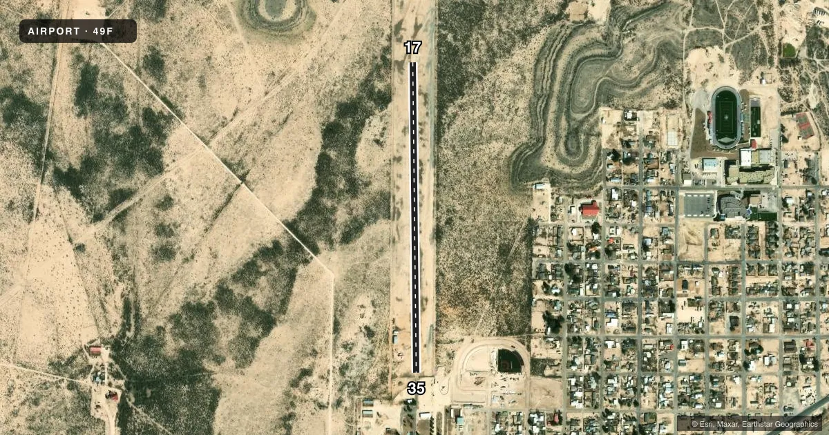
Runways & pattern
Full pagePattern entry · RWY 17
LEFT TRAFFICRunway end performance
| End | TORA | TODA | ASDA | LDA | VGSI | Approach lights | Obstruction |
|---|---|---|---|---|---|---|---|
| 17 | — | — | — | — | — | — | 60', hill, 1500' from thr, 0' R of cntrln, slope 25 |
| 35 | — | — | — | — | — | — | 40', trees, 350' from thr, 0' R of cntrln, slope 8 |
Declared distances in feet. TORA = takeoff run available, TODA = takeoff distance, ASDA = accelerate-stop, LDA = landing distance.
Airport sketch
Runways drawn to scale from FAA survey coordinates, rendered over satellite imagery. Not for navigation.
Approaches & charts
Services on the field
Fuel grades, oxygen, maintenance, ramp storage and lighting — as declared to the FAA by the airport operator.
Fuel & services
- Fuel
- Not available
- Airframe repair
- Not available
- Power plant repair
- Not available
Ramp & ground
- Transient storage
- Not published
- Landing fee
- No fee published
- Customs
- Not available
- Wind indicator
- Yes
- Segmented circle
- No
Fuel & FBOs
Cheapest 100LL and Jet A on the field and nearby. Always confirm with the FBO before taxi.
Airport notes
Surface conditions, obstructions, local procedures, lighting outages and other notes published with each FAA cycle.
General notes
- FOR CD CTC HOUSTON ARTCC AT 281-230-5622.
- RWY NOT MKD, DFCLT TO DTRM LCTN OF RWY IN FLD. DITCH ACRS N END OF RWY HIDDEN BY VEGETATION.
Other notes
- 1ARPT GATE LOCKED. FOR ACES CALL SHERIFF'S OFC 432-693-2411.
- MANAGEREXT 2.
- 17/35RWY ROUGH & UNEVEN, OVERGROWN W/VEGETATION, THORNS.
VFR map & nearby airports
VFR sectional. Tap any ICAO chip to open that airport.
Key facts · 49F
Answer card- ICAO
- 49F
- Name
- RANKIN
- Location
- RANKIN, TEXAS
- Elevation
- 2,543 ft MSL
- Traffic pattern altitude
- 3,543 ft MSL (1,000 AGL)
- Control tower
- Non-towered (use CTAF)
- Total runways
- 1
- Longest runway
- 17/35 · 3,000 ft
- Published ILS approaches
- 0
- Published frequencies
- 1
- Magnetic variation
- 9°
- Current flight rules
- VFR
- Current wind
- 150° at 10 kt
- Favored runway now
- RWY 17
Rankin Airport (49F) sits in Rankin, Texas. The field elevation is 2,543 ft MSL. It has one runway. Runway 17/35 is 3,000 ft long with a gravel-dirt surface. The airport is not towered. CTAF is 122.9. No ILS approaches are published here.
Pattern altitude is not published. Use the standard 1,000 ft AGL pattern unless the current Chart Supplement says otherwise. That puts the light-piston pattern at about 3,543 ft MSL. The published remarks matter here. The runway is rough and uneven. Vegetation and thorns are reported along the strip. The runway is not marked and the usable runway area can be hard to pick out from the field. A ditch crosses the north end of the runway. The airport gate is locked. For access, call the sheriff’s office before you go in.
There are no on-field FBOs listed. Plan on self-briefing and getting current field access details before departure. For clearance delivery, contact Houston ARTCC at 281-230-5622. This is a high-elevation West Texas field, so expect performance to change with temperature and density altitude. Verify the current Chart Supplement before flying in.