METAR & TAF E41
Current METAR
Observed 20:55Z
KE41 272055Z AUTO 16013G19KT 10SM CLR 35/16 A2997 RMK AO2 T03470158
- Wind
- 160° @ 13G19 kt
- Visibility
- 10 SM
- Temp / Dew
- 35°C / 16°C
- Altimeter
- 29.97 inHg
- Clouds
- CLR
- Density alt
- 5,693 ft
- Ceiling
- Unlimited
- Rules
- VFR
Airport info & contacts
Manager on record, flight service, ARTCC, attendance schedule and pattern altitude — published by the FAA and refreshed every 28 days.
Location
- From city
- 1 NM W
- VFR sectional
- SAN ANTONIO
- ARTCC
- ZFW · FORT WORTH
- NOTAM facility
- SJT (NOTAM-D)
Airport manager
- Name
- HEATH HOLT
- Phone
- 325-650-1314
- Address
- P. O BOX 100, BIG LAKE TX 76932
Flight service · Hours
- FSS SJT
- SAN ANGELO1-800-WX-BRIEF
- Attendance
- Unattended
Frequencies
Tap any row to copy the frequency to your clipboard.
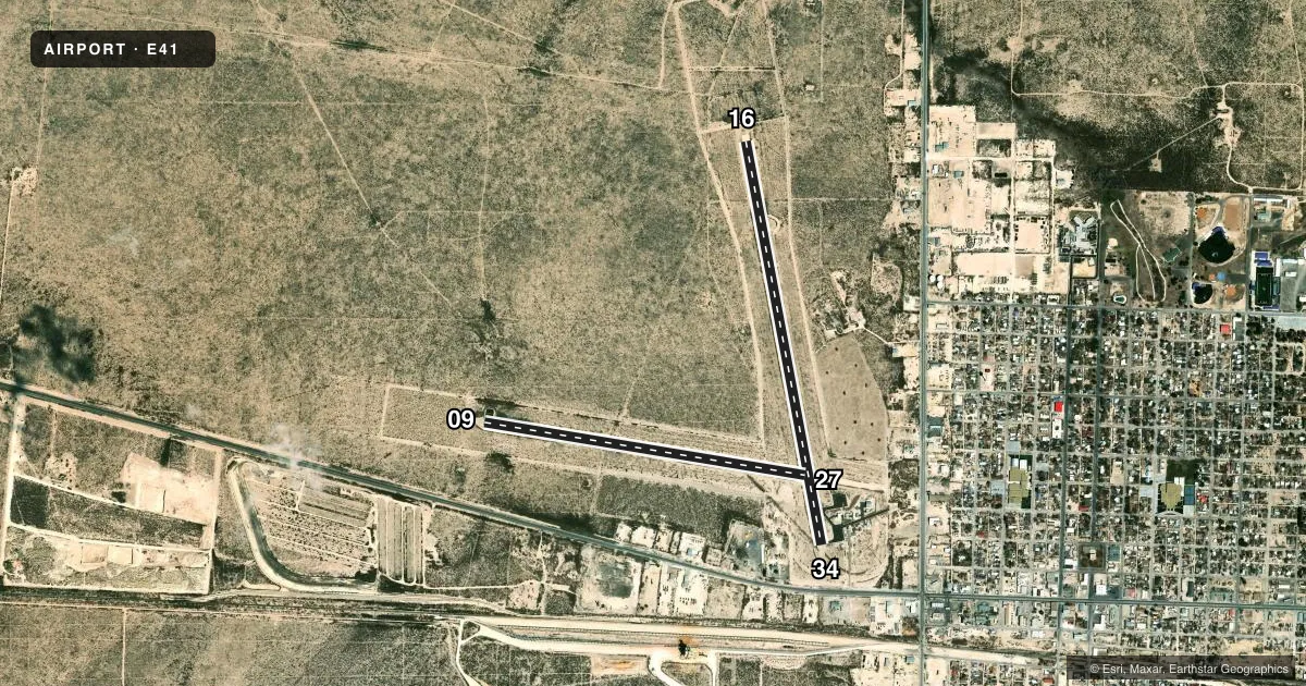
Runways & pattern
Full pagePattern entry · RWY 16
RIGHT TRAFFIC| Runway | Heading (°M) | Length | Surface | Traffic |
|---|---|---|---|---|
| 16/34Favored | 161° / 341° | 5,035 ft | ASPH | 16 R |
| 09/27 | 91° / 271° | 4,001 ft | ASPH | 27 R |
Runway end performance
| End | TORA | TODA | ASDA | LDA | VGSI | Approach lights | Obstruction |
|---|---|---|---|---|---|---|---|
| 16 | — | — | — | — | PAPI 2-box left(3°) | — | — |
| 34 | — | — | — | — | PAPI 2-box left(3.5°) | — | 44', pole, 764' from thr, 165' R of cntrln, slope 12 |
| 27 | — | — | — | — | — | — | 61', pole, 1606' from thr, 58' R of cntrln, slope 23 |
Declared distances in feet. TORA = takeoff run available, TODA = takeoff distance, ASDA = accelerate-stop, LDA = landing distance.
Airport sketch
Runways drawn to scale from FAA survey coordinates, rendered over satellite imagery. Not for navigation.
Approaches & charts
Services on the field
Fuel grades, oxygen, maintenance, ramp storage and lighting — as declared to the FAA by the airport operator.
Fuel & services
- Fuel
- 100LL
- Oxygen (bottled)
- Not available
- Oxygen (bulk)
- Not available
- Airframe repair
- Not available
- Power plant repair
- Not available
Ramp & ground
- Transient storage
- Tie-down
- Hangar
- Landing fee
- No fee published
- Customs
- Not available
- Lighting schedule
- SEE RMK
- Beacon schedule
- SS-SR
- Beacon
- White / Green (civil land)(WG)
- Wind indicator
- Lighted
- Segmented circle
- Yes
Fuel & FBOs
Cheapest 100LL and Jet A on the field and nearby. Always confirm with the FBO before taxi.
Airport notes
Surface conditions, obstructions, local procedures, lighting outages and other notes published with each FAA cycle.
General notes
- FOR CD CTC FORT WORTH ARTCC AT 817-858-7584.
Lighting notes
- ACTVT PAPI RWY 16 & 34; MIRL RWY 16/34 - CTAF.
Fuel notes
- 100LLFOR FUEL CALL 325-277-1551
Other notes
- MANAGERCOUNTY JUDGE.
- 09/27SFC SEAL SPALLING.
- 16/34LOOSE STONES ON THE RWY.
VFR map & nearby airports
VFR sectional. Tap any ICAO chip to open that airport.
Key facts · E41
Answer card- ICAO
- E41
- Name
- REAGAN COUNTY
- Location
- BIG LAKE, TEXAS
- Elevation
- 2,705.7 ft MSL
- Traffic pattern altitude
- 3,705.7 ft MSL (1,000 AGL)
- Control tower
- Non-towered (use CTAF)
- Total runways
- 2
- Longest runway
- 16/34 · 5,035 ft
- Published ILS approaches
- 0
- Published frequencies
- 1
- Magnetic variation
- 8°
- Current flight rules
- VFR
- Current wind
- 160° at 13 kt
- Favored runway now
- RWY 16
Reagan County Airport sits in Big Lake, Texas. The field elevation is 2,705.7 ft MSL. It has two asphalt runways. The longest is runway 16/34 at 5,035 ft. This is a non-towered field, so use CTAF 122.9 for traffic calls.
No ILS approaches are published here. Pattern altitude is not published, so a light piston pilot should plan on the standard 1,000 ft AGL unless the current Chart Supplement says otherwise. That puts the traffic pattern at about 3,705.7 ft MSL based on field elevation. Runway 16 and 34 have PAPI and medium intensity runway lights. Published remarks also note loose stones on runway 16/34. Runway 09/27 has surface seal spalling.
There is no on-field FBO listed in the facts. For fuel, call 325-277-1551 before you go. The airport manager is the county judge. For clearance delivery, contact Fort Worth ARTCC at 817-858-7584. Big Lake sits in west Texas with a high field elevation, so take density altitude into account on warm days. Check the current FAA Chart Supplement before departure for any updates on lighting, runway condition, or local procedures.