METAR & TAF KSJT
Current METAR
Observed 18:51Z
KSJT 271851Z 18010G18KT 10SM CLR 35/17 A2995 RMK AO2 SLP114 T03500172
- Wind
- 180° @ 10G18 kt
- Visibility
- 10 SM
- Temp / Dew
- 35°C / 17°C
- Altimeter
- 29.95 inHg
- Clouds
- CLR
- Density alt
- 4,742 ft
- Ceiling
- Unlimited
- Rules
- VFR
Airport info & contacts
Manager on record, flight service, ARTCC, attendance schedule and pattern altitude — published by the FAA and refreshed every 28 days.
Location
- From city
- 7 NM SW
- VFR sectional
- SAN ANTONIO
- ARTCC
- ZFW · FORT WORTH
- NOTAM facility
- SJT (NOTAM-D)
Airport manager
- Name
- JUSTIN FLETCHER
- Phone
- 325-659-6409
- Address
- 8618 TERMINAL DRIVE, SUITE 101, SAN ANGELO TX 76904
Flight service · Hours
- FSS SJT
- SAN ANGELO1-800-WX-BRIEF
- Attendance
- 0600-2200
Frequencies
Tap any row to copy the frequency to your clipboard.
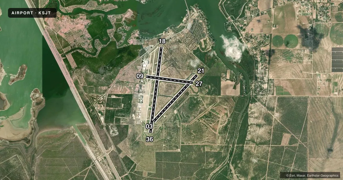
Runways & pattern
Full pagePattern entry · RWY 18
LEFT TRAFFIC| Runway | Heading (°M) | Length | Surface | Traffic |
|---|---|---|---|---|
| 18/36Favored | 182° / 2° | 8,054 ft | ASPH | Standard L |
| 03/21 | 38° / 218° | 5,940 ft | ASPH | Standard L |
| 09/27 | 92° / 272° | 4,406 ft | ASPH | Standard L |
Runway end performance
| End | TORA | TODA | ASDA | LDA | VGSI | Approach lights | Obstruction |
|---|---|---|---|---|---|---|---|
| 18 | 8,054' | 8,054' | 8,054' | 7,152' | PAPI 4-box left(3°) | — | 6', road, 380' from thr, 270' R of cntrln, slope 30 |
| 36 | 7,152' | 7,152' | 7,152' | 7,152' | PAPI 4-box left(3°) | — | — |
| 03 | 5,940' | 5,940' | 5,940' | 5,940' | — | MALSR | — |
| 21 | 5,940' | 5,940' | 5,940' | 5,940' | VASI 4-box left(3°) | — | — |
| 09 | 4,406' | 4,406' | 4,406' | 4,406' | — | — | 13', road, 529' from thr, 0' R of cntrln, slope 25 |
| 27 | 4,406' | 4,406' | 4,406' | 4,406' | — | — | 12', road, 633' from thr, 0' R of cntrln, slope 36 |
Declared distances in feet. TORA = takeoff run available, TODA = takeoff distance, ASDA = accelerate-stop, LDA = landing distance.
Airport sketch
Runways drawn to scale from FAA survey coordinates, rendered over satellite imagery. Not for navigation.
Approaches & charts
ILS · 1
Services on the field
Fuel grades, oxygen, maintenance, ramp storage and lighting — as declared to the FAA by the airport operator.
Fuel & services
- Fuel
- 100LLA
- Oxygen (bottled)
- Low pressure
- Oxygen (bulk)
- HIGH/LOW
- Airframe repair
- Major
- Power plant repair
- Major
- Other services
- AFRT,AMB,AVNCS,CHTR,INSTR,RNTL,SALES
Ramp & ground
- Transient storage
- Tie-down
- Hangar
- Landing fee
- Yes
- Customs
- Not available
- Lighting schedule
- SEE RMK
- Beacon schedule
- SS-SR
- Beacon
- White / Green (civil land)(WG)
- Wind indicator
- Lighted
- Segmented circle
- Yes
Fuel & FBOs
Cheapest 100LL and Jet A on the field and nearby. Always confirm with the FBO before taxi.
Airport notes
Surface conditions, obstructions, local procedures, lighting outages and other notes published with each FAA cycle.
General notes
- FOR CD IF UNA TO CTC ON FSS FREQ, CTC FORT WORTH ARTCC AT 817-858-7584.
Lighting notes
- DUSK-DAWN. WHEN ATCT CLSD MIRL RWY 18/36 PRESET LOW INTST. TO INCR INTST & ACTVT MALSR RWY 03; REIL RWY 18; PAPI RWYS 18 & 36; HIRL RWY 03/21; MIRL RWY 09/27 - CTAF.
Fuel notes
- 100LLFEE FOR FUEL AFT HRS CALL 325-656-1836/1837.
Runway surface & condition
- 03/21PCR VALUE: 450/F/B/X/T
- 09/27PCR VALUE: 170/F/C/X/T
- 18/36PCR VALUE: 490/F/C/X/T
Approach & departure obstructions
- 18ROAD 270 FT RIGHT AT CONTROLLING POINT RWY 18.
- 18APCH RATIO 50+:1 TO DSPLCD THR.
Other notes
- PPR 12 HRS FOR UNSKED ACR OPNS WITH OVER 30 PSGR SEATS CALL AMGR 325-659-6409.
- 09/27RWY SLATED FOR CLOSURE
VFR map & nearby airports
VFR sectional. Tap any ICAO chip to open that airport.
Key facts · KSJT
Answer card- ICAO
- KSJT
- Name
- SAN ANGELO RGNL/MATHIS FLD
- Location
- SAN ANGELO, TEXAS
- Elevation
- 1,918.6 ft MSL
- Traffic pattern altitude
- 2,918.6 ft MSL (1,000 AGL)
- Control tower
- Towered · 0700-2100
- Total runways
- 3
- Longest runway
- 18/36 · 8,054 ft
- Published ILS approaches
- 1
- Published frequencies
- 12
- Magnetic variation
- 5°
- Current flight rules
- VFR
- Current wind
- 180° at 10 kt
- Favored runway now
- RWY 18
KSJT is in San Angelo, Texas. The field elevation is 1,918.6 ft MSL. It has three asphalt runways. The longest is runway 18/36 at 8,054 ft. The airport is towered. Tower hours are 0700 to 2100.
Runway 03 has the published ILS. That is the main precision option in the facts provided. Pattern altitude is not published, so use the standard 1,000 ft AGL for light piston traffic unless ATC or the current Chart Supplement says otherwise. The airport sits in west Texas terrain with a higher field elevation than many regional airports, so density altitude can matter on warm days.
Ranger Aviation is on the field. It carries 100LL and Jet A Prist. San Angelo Jet Center is also on the field. It carries 100LL, Jet A and Jet A Prist. The published remarks also note after-hours fuel fees for 100LL, so call ahead if you expect to arrive late. Runway 09/27 is slated for closure. Verify current runway status before you go. There is also a road 270 ft to the right at the controlling point of runway 18. For a large unscheduled aircraft operation with more than 30 passenger seats, prior permission is required 12 hours in advance.