METAR & TAF KOZA
Current METAR
Observed 03:35Z
KOZA 270335Z AUTO 14003KT 10SM CLR 27/15 A3005 RMK AO2
- Wind
- 140° @ 3 kt
- Visibility
- 10 SM
- Temp / Dew
- 27°C / 15°C
- Altimeter
- 30.05 inHg
- Clouds
- CLR
- Density alt
- 4,226 ft
- Ceiling
- Unlimited
- Rules
- VFR
Airport info & contacts
Manager on record, flight service, ARTCC, attendance schedule and pattern altitude — published by the FAA and refreshed every 28 days.
Location
- From city
- 1 NM N
- VFR sectional
- SAN ANTONIO
- ARTCC
- ZHU · HOUSTON
- NOTAM facility
- SJT (NOTAM-D)
Airport manager
- Name
- CHARLES MCCLEARY
- Phone
- 325-392-2030
- Address
- BOX 426, OZONA TX 76943
Flight service · Hours
- FSS SJT
- SAN ANGELO1-800-WX-BRIEF
- Attendance
- MON-FRI · 0800-1700
Frequencies
Tap any row to copy the frequency to your clipboard.
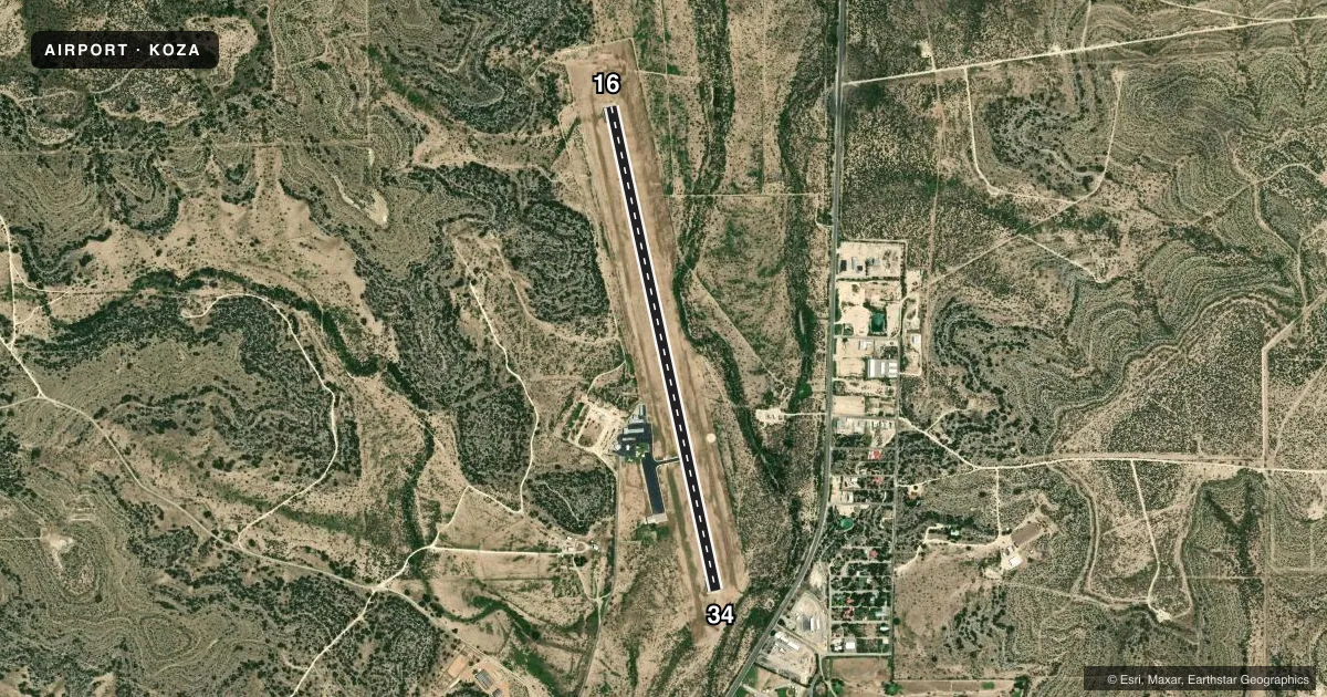
Runways & pattern
Full pagePattern entry · RWY 16
LEFT TRAFFICRunway end performance
| End | TORA | TODA | ASDA | LDA | VGSI | Approach lights | Obstruction |
|---|---|---|---|---|---|---|---|
| 16 | — | — | — | — | PAPI 4-box left(3°) | — | 40', trees, 830' from thr, 350' R of cntrln, slope 15 |
| 34 | — | — | — | — | PAPI 4-box left(3°) | — | 50', pole, 1200' from thr, 45' R of cntrln, slope 20 |
Declared distances in feet. TORA = takeoff run available, TODA = takeoff distance, ASDA = accelerate-stop, LDA = landing distance.
Airport sketch
Runways drawn to scale from FAA survey coordinates, rendered over satellite imagery. Not for navigation.
Approaches & charts
Services on the field
Fuel grades, oxygen, maintenance, ramp storage and lighting — as declared to the FAA by the airport operator.
Fuel & services
- Fuel
- 100LLA
Ramp & ground
- Transient storage
- Tie-down
- Landing fee
- No fee published
- Customs
- Not available
- Lighting schedule
- SEE RMK
- Beacon schedule
- SS-SR
- Beacon
- White / Green (civil land)(WG)
- Wind indicator
- Lighted
- Segmented circle
- Yes
Fuel & FBOs
Cheapest 100LL and Jet A on the field and nearby. Always confirm with the FBO before taxi.
Airport notes
Surface conditions, obstructions, local procedures, lighting outages and other notes published with each FAA cycle.
General notes
- FOR CD CTC HOUSTON ARTCC AT 281-230-5622.
Lighting notes
- RWY 16/34 MIRL PRESET MED INTST; TO INCR INTST ACTVT - CTAF.
Fuel notes
- 100LLFOR AFT HRS FUEL CALL 325-226-2628.
Other notes
- MANAGERARPT PHYS ADDRESS 319 CR 308.
VFR map & nearby airports
VFR sectional. Tap any ICAO chip to open that airport.
Key facts · KOZA
Answer card- ICAO
- KOZA
- Name
- OZONA MUNI
- Location
- OZONA, TEXAS
- Elevation
- 2,376.9 ft MSL
- Traffic pattern altitude
- 3,376.9 ft MSL (1,000 AGL)
- Control tower
- Non-towered (use CTAF)
- Total runways
- 1
- Longest runway
- 16/34 · 6,003 ft
- Published ILS approaches
- 0
- Published frequencies
- 2
- Magnetic variation
- 8°
- Current flight rules
- VFR
- Current wind
- 140° at 3 kt
- Favored runway now
- RWY 16
Ozona Muni sits in Ozona, Texas. The field elevation is 2,376.9 ft MSL. It has one runway, 16/34, which is 6,003 ft long. There is no control tower. CTAF and UNICOM are both 122.8. No ILS approaches are published here.
Pattern altitude is not published. For a light piston, use the standard 1,000 ft AGL unless the current Chart Supplement says otherwise. That puts the pattern at about 3,376.9 ft MSL based on the field elevation. Verify the published pattern before you fly. Runway 16/34 has medium intensity edge lights. The lights are preset. Use the CTAF to increase intensity if needed.
McCleary Aircraft is on the field. It carries 100LL and Jet A Prist. For after-hours fuel, the published remark gives a phone number to call. Clearance delivery is handled through Houston ARTCC, not a tower on the field. The airport physical address is 319 CR 308. This is a good airport to brief with the elevation in mind. Performance planning matters here, especially on warm Texas days. Check the current FAA Chart Supplement for any changes before departure.