METAR & TAF 27R
27R does not publish a METAR.
Showing the nearest reporting station: KSOA (SONORA MUNI) · 16.7 NM away. Conditions at 27R may differ.
METAR · KSOA
Observed 19:35Z
KSOA 271935Z AUTO 17010G18KT 10SM 34/17 A3001 RMK AO2
- Wind
- 170° @ 10G18 kt
- Visibility
- 10 SM
- Temp / Dew
- 34°C / 17°C
- Altimeter
- 30.01 inHg
- Clouds
- Clear
- Density alt
- 5,204 ft
- Ceiling
- Unlimited
- Rules
- VFR
Airport info & contacts
Manager on record, flight service, ARTCC, attendance schedule and pattern altitude — published by the FAA and refreshed every 28 days.
Location
- From city
- 1 NM W
- VFR sectional
- SAN ANTONIO
- ARTCC
- ZFW · FORT WORTH
- NOTAM facility
- SJT (NOTAM-D)
Airport manager
- Name
- CHARLIE BRADLEY /CO JUDGE/
- Phone
- 325-853-2593
- Address
- P.O. BOX 536, ELDORADO TX 76936
Flight service · Hours
- FSS SJT
- SAN ANGELO1-800-WX-BRIEF
- Attendance
- Unattended
Frequencies
Tap any row to copy the frequency to your clipboard.
Runways & pattern
Full pagePattern entry · RWY 17
RIGHT TRAFFICRunway end performance
| End | TORA | TODA | ASDA | LDA | VGSI | Approach lights | Obstruction |
|---|---|---|---|---|---|---|---|
| 17 | — | — | — | — | PAPI 2-box left(3°) | — | 32', pole, 535' from thr, 160' R of cntrln, slope 10 |
| 35 | — | — | — | — | PAPI 2-box left(3°) | — | 15', road, 450' from thr, 0' R of cntrln, slope 16 |
Declared distances in feet. TORA = takeoff run available, TODA = takeoff distance, ASDA = accelerate-stop, LDA = landing distance.
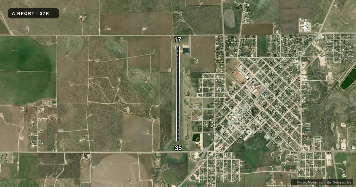
Airport sketch
Runways drawn to scale from FAA survey coordinates, rendered over satellite imagery. Not for navigation.
Approaches & charts
Services on the field
Fuel grades, oxygen, maintenance, ramp storage and lighting — as declared to the FAA by the airport operator.
Fuel & services
- Fuel
- 100LL
- Airframe repair
- Not available
- Power plant repair
- Not available
- Other services
- AGRI
Ramp & ground
- Transient storage
- Tie-down
- Landing fee
- No fee published
- Customs
- Not available
- Lighting schedule
- SEE RMK
- Beacon schedule
- SS-SR
- Beacon
- White / Green (civil land)(WG)
- Wind indicator
- Lighted
- Segmented circle
- No
Fuel & FBOs
Cheapest 100LL and Jet A on the field and nearby. Always confirm with the FBO before taxi.
Airport notes
Surface conditions, obstructions, local procedures, lighting outages and other notes published with each FAA cycle.
General notes
- FOR CD CTC SAN ANGELO APCH AT 432-563-2123. WHEN APCH CLSD CTC FORT WORTH ARTCC AT 817-858-7584.
Lighting notes
- MIRL RWY 17/35 PRESET TO LOW INTST, TO INCR INTST AND ACTVT PAPI - CTAF.
Fuel notes
- 100LLFOR FUEL CALL 325-853-2036/2737 OR 325-650-9553
Approach & departure obstructions
- 17RWY 34 ALSO 65 FT PWRLINE, 1425 FT DSTC, 0 FT BOTH, 18:1. NOT MKD.
VFR map & nearby airports
VFR sectional. Tap any ICAO chip to open that airport.
Key facts · 27R
Answer card- ICAO
- 27R
- Name
- ELDORADO
- Location
- ELDORADO, TEXAS
- Elevation
- 2,448 ft MSL
- Traffic pattern altitude
- 3,448 ft MSL (1,000 AGL)
- Control tower
- Non-towered (use CTAF)
- Total runways
- 1
- Longest runway
- 17/35 · 4,300 ft
- Published ILS approaches
- 0
- Published frequencies
- 2
- Magnetic variation
- 8°
- Current flight rules
- VFR
- Current wind
- 170° at 10 kt
- Favored runway now
- RWY 17
Eldorado Airport sits in Eldorado, Texas. Field elevation is 2,448 ft MSL. The airport has one runway. Runway 17/35 is 4,300 ft long with an asphalt surface. There is no control tower. CTAF and UNICOM are both 123.0. No ILS approaches are published.
Pattern altitude is not published. Use the standard 1,000 ft AGL pattern unless the current Chart Supplement says otherwise. That puts the light piston pattern at 3,448 ft MSL based on the field elevation, but verify before you fly. The on-field FBO is Eldorado Airport. It carries 100LL. Call ahead if you need fuel or current field status.
Published remarks matter here. Runway 34 has an unmarked 65-foot powerline obstruction 1,425 ft from the runway. The runway lights on 17/35 are preset to low intensity. Use the CTAF to increase lighting intensity and to activate the precision approach path indicator. For clearance delivery, contact San Angelo Approach. If approach is closed, Fort Worth ARTCC is the backup contact. This is a non-towered field at moderate elevation, so plan for density altitude and keep the departure and landing picture tight.