METAR & TAF T50
T50 does not publish a METAR.
Showing the nearest reporting station: KJCT (KIMBLE COUNTY) · 25.4 NM away. Conditions at T50 may differ.
METAR · KJCT
Observed 13:51Z
KJCT 271351Z AUTO 00000KT 10SM CLR 26/22 A3001 RMK AO2 SLP124 T02560222
- Wind
- 000° @ 0 kt
- Visibility
- 10 SM
- Temp / Dew
- 26°C / 22°C
- Altimeter
- 30.01 inHg
- Clouds
- CLR
- Density alt
- 3,605 ft
- Ceiling
- Unlimited
- Rules
- VFR
Airport info & contacts
Manager on record, flight service, ARTCC, attendance schedule and pattern altitude — published by the FAA and refreshed every 28 days.
Location
- From city
- 3 NM NW
- VFR sectional
- SAN ANTONIO
- ARTCC
- ZHU · HOUSTON
- NOTAM facility
- SJT (NOTAM-D)
Airport manager
- Name
- BRANDON CORBIN
- Phone
- 325-396-4789
- Address
- PO BOX 1038, MENARD TX 76859
Flight service · Hours
- FSS SJT
- SAN ANGELO1-800-WX-BRIEF
- Attendance
- Unattended
Frequencies
Tap any row to copy the frequency to your clipboard.
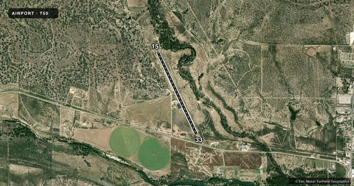
Runways & pattern
Full pagePattern entry · RWY 15
LEFT TRAFFICRunway end performance
| End | TORA | TODA | ASDA | LDA | VGSI | Approach lights | Obstruction |
|---|---|---|---|---|---|---|---|
| 15 | — | — | — | — | PAPI 2-box left(3°) | — | 18', trees, 200' from thr, 0' R of cntrln, slope 0 |
| 33 | — | — | — | — | PAPI 2-box left(3°) | — | 12', road, 394' from thr, 141' R of cntrln, slope 16 |
Declared distances in feet. TORA = takeoff run available, TODA = takeoff distance, ASDA = accelerate-stop, LDA = landing distance.
Airport sketch
Runways drawn to scale from FAA survey coordinates, rendered over satellite imagery. Not for navigation.
Approaches & charts
Services on the field
Fuel grades, oxygen, maintenance, ramp storage and lighting — as declared to the FAA by the airport operator.
Fuel & services
- Fuel
- Not available
- Oxygen (bottled)
- Not available
- Oxygen (bulk)
- Not available
- Airframe repair
- Not available
- Power plant repair
- Not available
Ramp & ground
- Transient storage
- Tie-down
- Landing fee
- No fee published
- Customs
- Not available
- Lighting schedule
- SEE RMK
- Beacon schedule
- SS-SR
- Beacon
- White / Green (civil land)(WG)
- Wind indicator
- Lighted
- Segmented circle
- Yes
Fuel & FBOs
Cheapest 100LL and Jet A on the field and nearby. Always confirm with the FBO before taxi.
Airport notes
Surface conditions, obstructions, local procedures, lighting outages and other notes published with each FAA cycle.
General notes
- BIRDS ON & INVOF ARPT.
- FOR CD CTC HOUSTON ARTCC AT 281-230-5622.
Lighting notes
- MIRL RWY 15/33 PRESET LOW INTST; TO INCR INTST ACTVT CTAF. PAPI RWYS 15 & 33 OPRS CONSLY.
Approach & departure obstructions
- 158 FT FENCE 130 FT FROM THR.
- 15MARKINGS FADED-BARELY VISIBLE.
- 33MARKINGS FADED-BARELY VISIBLE.
- 15PAPI OTS
- 33PAPI OTS.
- 15APCH RATIO 26:1 AT DSPLCD THR OVR 25 FT TREE, 660 FT DSTC, 180 FT L.
Other notes
- MANAGERCOUNTY JUDGE/ARPT.MGR
VFR map & nearby airports
VFR sectional. Tap any ICAO chip to open that airport.
Key facts · T50
Answer card- ICAO
- T50
- Name
- MENARD COUNTY
- Location
- MENARD, TEXAS
- Elevation
- 1,933 ft MSL
- Traffic pattern altitude
- 2,933 ft MSL (1,000 AGL)
- Control tower
- Non-towered (use CTAF)
- Total runways
- 1
- Longest runway
- 15/33 · 4,100 ft
- Published ILS approaches
- 0
- Published frequencies
- 1
- Magnetic variation
- 8°
- Current flight rules
- VFR
- Current wind
- 000° at 0 kt
- Favored runway now
- –
Menard County Airport sits in Menard, Texas at 1,933 ft MSL. It has one runway. Runway 15/33 is 4,100 ft long and asphalt. The field is not towered. CTAF is 122.9.
No ILS approaches are published here. Pattern altitude is not published, so use the standard 1,000 ft AGL unless the current Chart Supplement says otherwise. The runway lighting on 15/33 is medium intensity. It starts at low intensity. You can increase it by keying the CTAF. The PAPI systems are listed as operating continuously, but the published remarks also say the PAPI on both runway ends is out of service. Check the current Chart Supplement before you go.
There are no on-field FBOs listed. Contact the airport operator directly or call the field on CTAF for current services. The published remarks also note birds in and around the airport. There is a 25-foot tree near the displaced threshold area for runway 15, plus an 8-foot fence near that threshold. Runway markings on both ends are faded and barely visible. The airport manager is the county judge. For clearance delivery, contact Houston ARTCC at 281-230-5622.