METAR & TAF T92
T92 does not publish a METAR.
Showing the nearest reporting station: KAQO (LLANO MUNI) · 27.2 NM away. Conditions at T92 may differ.
METAR · KAQO
Observed 16:35Z
KAQO 271635Z AUTO 00000KT 10SM CLR 32/19 A3001 RMK AO2
- Wind
- 000° @ 0 kt
- Visibility
- 10 SM
- Temp / Dew
- 32°C / 19°C
- Altimeter
- 30.01 inHg
- Clouds
- CLR
- Density alt
- 3,806 ft
- Ceiling
- Unlimited
- Rules
- VFR
Airport info & contacts
Manager on record, flight service, ARTCC, attendance schedule and pattern altitude — published by the FAA and refreshed every 28 days.
Location
- From city
- 3 NM SE
- VFR sectional
- SAN ANTONIO
- ARTCC
- ZHU · HOUSTON
- NOTAM facility
- SJT (NOTAM-D)
Airport manager
- Name
- C. SHEREE HARDIN
- Phone
- 325-347-5556
- Address
- COUNTY COURTHOUSE, 201 FT MCKAVITT, MASON TX 76856
Flight service · Hours
- FSS SJT
- SAN ANGELO1-800-WX-BRIEF
- Attendance
- Unattended
Frequencies
Tap any row to copy the frequency to your clipboard.
Runways & pattern
Full pagePattern entry · RWY 18
LEFT TRAFFICRunway end performance
| End | TORA | TODA | ASDA | LDA | VGSI | Approach lights | Obstruction |
|---|---|---|---|---|---|---|---|
| 18 | — | — | — | — | PAPI 2-box left(3.25°) | — | 29', trees, 965' from thr, 0' R of cntrln, slope 26 |
| 36 | — | — | — | — | PAPI 2-box left(3°) | — | — |
Declared distances in feet. TORA = takeoff run available, TODA = takeoff distance, ASDA = accelerate-stop, LDA = landing distance.
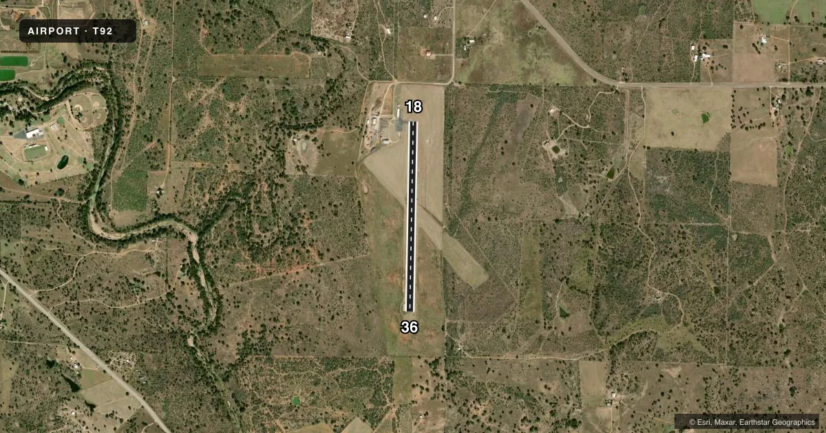
Airport sketch
Runways drawn to scale from FAA survey coordinates, rendered over satellite imagery. Not for navigation.
Approaches & charts
Services on the field
Fuel grades, oxygen, maintenance, ramp storage and lighting — as declared to the FAA by the airport operator.
Fuel & services
- Fuel
- 100LL
- Oxygen (bottled)
- Not available
- Oxygen (bulk)
- Not available
Ramp & ground
- Transient storage
- Tie-down
- Landing fee
- No fee published
- Customs
- Not available
- Lighting schedule
- SS-SR
- Beacon schedule
- SS-SR
- Beacon
- White / Green (civil land)(WG)
- Wind indicator
- Lighted
- Segmented circle
- Yes
Fuel & FBOs
Cheapest 100LL and Jet A on the field and nearby. Always confirm with the FBO before taxi.
Airport notes
Surface conditions, obstructions, local procedures, lighting outages and other notes published with each FAA cycle.
General notes
- HVY TSNT TFC NOV-JAN.
- DEER ON AND INVOF RWY.
- FOR CD CTC HOUSTON ARTCC AT 281-230-5622.
Fuel notes
- 100LLFUEL 24 HRS SELF SERVE. FOR ASSITANCE CALL 325-347-5252 (COUNTY SHERIFF).
Other notes
- MANAGERCOUNTY JUDGE/ARPT MGR.
VFR map & nearby airports
VFR sectional. Tap any ICAO chip to open that airport.
Key facts · T92
Answer card- ICAO
- T92
- Name
- MASON COUNTY
- Location
- MASON, TEXAS
- Elevation
- 1,514 ft MSL
- Traffic pattern altitude
- 2,514 ft MSL (1,000 AGL)
- Control tower
- Non-towered (use CTAF)
- Total runways
- 1
- Longest runway
- 18/36 · 3,716 ft
- Published ILS approaches
- 0
- Published frequencies
- 1
- Magnetic variation
- 5°
- Current flight rules
- VFR
- Current wind
- 000° at 0 kt
- Favored runway now
- –
Mason County Airport sits in Mason, Texas. Field elevation is 1,514 ft MSL. The airport has one runway. Runway 18/36 is 3,716 ft of asphalt with magnetic headings 181° and 1°. There is no control tower. CTAF is 122.9. No ILS approaches are published here.
Pattern altitude is not published in the facts. Use the standard 1,000 ft AGL unless the current Chart Supplement says otherwise. Mason County Airport, the on-field FBO, carries 100LL. Fuel is available 24 hours self-serve. If you need help after hours, the published number is the County Sheriff at (325) 347-5252. The airport manager is the County Judge.
Plan for deer on and near the runway. That matters at this field. Heavy transient traffic is also published for November through January, so expect more traffic during that stretch. For clearance delivery, contact Houston ARTCC at 281-230-5622. Before you go, check the current Chart Supplement for any changes to procedures or local restrictions.