METAR & TAF T82
Current METAR
Observed 13:15Z
KT82 271315Z AUTO 20004KT 10SM CLR 24/21 A3003 RMK AO2
- Wind
- 200° @ 4 kt
- Visibility
- 10 SM
- Temp / Dew
- 24°C / 21°C
- Altimeter
- 30.03 inHg
- Clouds
- CLR
- Density alt
- 3,045 ft
- Ceiling
- Unlimited
- Rules
- VFR
Airport info & contacts
Manager on record, flight service, ARTCC, attendance schedule and pattern altitude — published by the FAA and refreshed every 28 days.
Location
- From city
- 3 NM SW
- VFR sectional
- SAN ANTONIO
- ARTCC
- ZHU · HOUSTON
- NOTAM facility
- T82 (NOTAM-D)
Airport manager
- Name
- TONY LOMBARDI
- Phone
- 830-990-5764
- Address
- 101 W MAIN UNIT 9, FREDERICKSBURG TX 78624
Flight service · Hours
- FSS SJT
- SAN ANGELO1-800-WX-BRIEF
- Attendance
- 0800-1800
Frequencies
Tap any row to copy the frequency to your clipboard.
Runways & pattern
Full pagePattern entry · RWY 14
RIGHT TRAFFICRunway end performance
| End | TORA | TODA | ASDA | LDA | VGSI | Approach lights | Obstruction |
|---|---|---|---|---|---|---|---|
| 14 | — | — | — | — | PAPI 2-box left(3°) | — | 3', fence, 200' from thr, 216' R of cntrln, slope 0 |
| 32 | — | — | — | — | PAPI 2-box left(3°) | — | 12', road, 357' from thr, 250' R of cntrln, slope 13 |
Declared distances in feet. TORA = takeoff run available, TODA = takeoff distance, ASDA = accelerate-stop, LDA = landing distance.
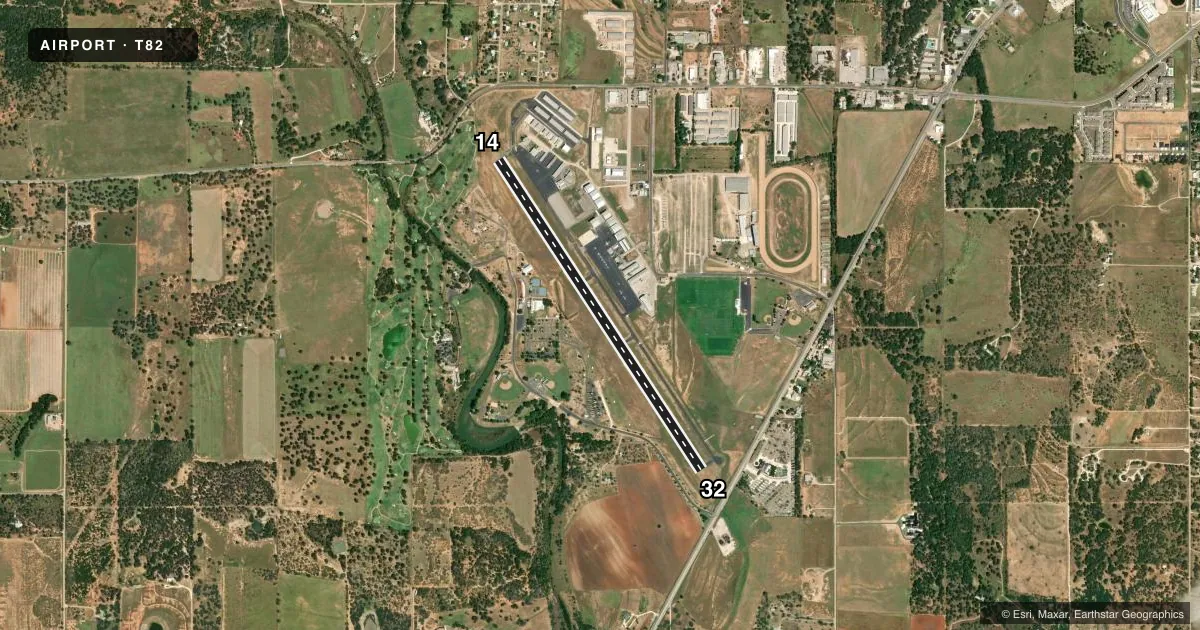
Airport sketch
Runways drawn to scale from FAA survey coordinates, rendered over satellite imagery. Not for navigation.
Approaches & charts
Services on the field
Fuel grades, oxygen, maintenance, ramp storage and lighting — as declared to the FAA by the airport operator.
Fuel & services
- Fuel
- 100LLA
- Oxygen (bottled)
- Not available
- Oxygen (bulk)
- Not available
- Airframe repair
- Major
- Power plant repair
- Major
- Other services
- AVNCS,INSTR,RNTL
Ramp & ground
- Transient storage
- Tie-down
- Hangar
- Landing fee
- No fee published
- Customs
- Not available
- Lighting schedule
- SEE RMK
- Beacon schedule
- SS-SR
- Beacon
- White / Green (civil land)(WG)
- Wind indicator
- Lighted
- Segmented circle
- Yes
Fuel & FBOs
Cheapest 100LL and Jet A on the field and nearby. Always confirm with the FBO before taxi.
Airport notes
Surface conditions, obstructions, local procedures, lighting outages and other notes published with each FAA cycle.
General notes
- 75 FT TANK 300 FT SE OF ROTG BCN.
- FBO 830-997-3313.
- SEASONAL FFR AIR OPNS IN AND OUT OF ARPT.
- FOR CD IF UNA VIA GCO CTC HOUSTON ARTCC AT 281-230-5622.
- VOLUNTARY NOISE ABATEMENT PROCS IN EFFECT; SEE ARPT WEBSITE. AVOID HOUSES 60 DEGS AT .35 NM FROM DEP END RWY 14.
Lighting notes
- RWY 14/32 MIRL PRESET LOW INTST; TO INCR INTST ACTVT - CTAF.
Fuel notes
- 100LLFUEL 24 HR SELF SERVE. FULL SERV AVBL DURING ATND HRS.
Approach & departure obstructions
- 143 FT FENCE 190-200 FT FM THLD 216 FT RIGHT.
- 14ALSO 30 FT TREES 680 FT DSTC ACRS APCH.
Other notes
- PREDATES THE ACT.
VFR map & nearby airports
VFR sectional. Tap any ICAO chip to open that airport.
Key facts · T82
Answer card- ICAO
- T82
- Name
- GILLESPIE COUNTY
- Location
- FREDERICKSBURG, TEXAS
- Elevation
- 1,694.9 ft MSL
- Traffic pattern altitude
- 2,694.9 ft MSL (1,000 AGL)
- Control tower
- Non-towered (use CTAF)
- Total runways
- 1
- Longest runway
- 14/32 · 5,002 ft
- Published ILS approaches
- 0
- Published frequencies
- 2
- Magnetic variation
- 6°
- Current flight rules
- VFR
- Current wind
- 200° at 4 kt
- Favored runway now
- RWY 14
Gillespie County Airport sits in Fredericksburg, Texas. The field elevation is 1,694.9 ft MSL. It has one runway, 14/32, which is 5,002 ft long. The airport is non-towered. CTAF and UNICOM are both 122.7. No ILS approaches are published here.
Use the standard 1,000 ft AGL pattern unless local guidance says otherwise. That puts the light piston pattern at 2,694.9 ft MSL. The runway has medium intensity edge lights that come up at low intensity by default. Use the CTAF to increase intensity.
Fredericksburg is on the field. It carries 100LL, Jet A and Jet A Prist. Fuel is available 24 hours self-serve. Full service is available during attended hours. The FBO can be reached at (830) 997-3313.
A few published remarks matter here. There is a fence near the approach to runway 14. There are also trees beyond that approach path. A tank sits southeast of the rotating beacon. Seasonal firefighting aircraft also operate here, so expect a busy ramp at times. The airport predates the Airport Compliance Act. Check the current FAA Chart Supplement for any local procedures or restrictions before you go. If clearance delivery is needed and ground communications are unavailable, contact Houston ARTCC.