METAR & TAF KERV
Current METAR
Observed 15:35Z
KERV 271535Z AUTO 17008KT 10SM CLR 27/22 A3003 RMK AO2 T02670215
- Wind
- 170° @ 8 kt
- Visibility
- 10 SM
- Temp / Dew
- 27°C / 22°C
- Altimeter
- 30.03 inHg
- Clouds
- CLR
- Density alt
- 3,308 ft
- Ceiling
- Unlimited
- Rules
- VFR
Airport info & contacts
Manager on record, flight service, ARTCC, attendance schedule and pattern altitude — published by the FAA and refreshed every 28 days.
Location
- From city
- 5 NM SE
- VFR sectional
- SAN ANTONIO
- ARTCC
- ZHU · HOUSTON
- NOTAM facility
- ERV (NOTAM-D)
Airport manager
- Name
- MARY L ROHRER
- Phone
- 830-896-9399
- Address
- 1877 AIRPORT LOOP, KERRVILLE TX 78028-5069
Flight service · Hours
- FSS SJT
- SAN ANGELO1-800-WX-BRIEF
- Attendance
- 0600-2200
Frequencies
Tap any row to copy the frequency to your clipboard.
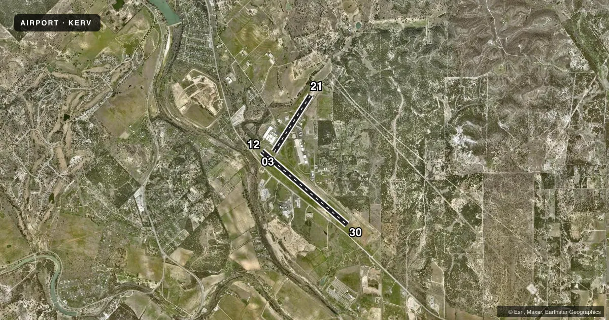
Runways & pattern
Full pagePattern entry · RWY 12
LEFT TRAFFIC| Runway | Heading (°M) | Length | Surface | Traffic |
|---|---|---|---|---|
| 12/30Favored | 125° / 305° | 6,004 ft | ASPH | Standard L |
| 03/21 | 27° / 207° | 3,597 ft | ASPH | Standard L |
Runway end performance
| End | TORA | TODA | ASDA | LDA | VGSI | Approach lights | Obstruction |
|---|---|---|---|---|---|---|---|
| 12 | 6,000' | 6,000' | 6,000' | 5,313' | PAPI 4-box left(3°) | — | — |
| 30 | 6,000' | 6,000' | 5,300' | 5,300' | PAPI 4-box left(3°) | — | — |
| 03 | — | — | — | — | PAPI 2-box left(3.5°) | — | 40', tree, 940' from thr, 130' R of cntrln, slope 18 |
| 21 | — | — | — | — | PAPI 2-box left(3.5°) | — | 50', trees, 960' from thr, 290' R of cntrln, slope 15 |
Declared distances in feet. TORA = takeoff run available, TODA = takeoff distance, ASDA = accelerate-stop, LDA = landing distance.
Airport sketch
Runways drawn to scale from FAA survey coordinates, rendered over satellite imagery. Not for navigation.
Approaches & charts
ILS · 1
Services on the field
Fuel grades, oxygen, maintenance, ramp storage and lighting — as declared to the FAA by the airport operator.
Fuel & services
- Fuel
- 100LLA
- Oxygen (bottled)
- High pressure
- Airframe repair
- Major
- Power plant repair
- Major
- Other services
- AVNCS,INSTR,RNTL,SALES
Ramp & ground
- Transient storage
- Tie-down
- Hangar
- Landing fee
- No fee published
- Customs
- Not available
- Lighting schedule
- SEE RMK
- Beacon schedule
- SS-SR
- Beacon
- White / Green (civil land)(WG)
- Wind indicator
- Lighted
- Segmented circle
- Yes
Fuel & FBOs
Cheapest 100LL and Jet A on the field and nearby. Always confirm with the FBO before taxi.
Airport notes
Surface conditions, obstructions, local procedures, lighting outages and other notes published with each FAA cycle.
General notes
- DEER ON & INVOF ARPT.
- RWY 12 CALM WIND RWY.
- FOR CD CTC HOUSTON ARTCC AT 281-230-5622.
Lighting notes
- DUSK-DAWN. MIRL RWYS 12/30 & 03/21 PRESET LOW INTST; TO INCR INTST AND ACTVT REIL RWYS 12 & 30 - CTAF.
Approach & departure obstructions
- 12APCH SLOPE 41:1 TO DSPLCD THR.
Other notes
- 1FBO PH 830-257-8840, AFT HRS ATTENDANT 830-496-0332.
- OWNERAND KERR COUNTY JOINTLY
VFR map & nearby airports
VFR sectional. Tap any ICAO chip to open that airport.
Key facts · KERV
Answer card- ICAO
- KERV
- Name
- KERRVILLE MUNI/LOUIS SCHREINER FLD
- Location
- KERRVILLE, TEXAS
- Elevation
- 1,616.8 ft MSL
- Traffic pattern altitude
- 2,616.8 ft MSL (1,000 AGL)
- Control tower
- Non-towered (use CTAF)
- Total runways
- 2
- Longest runway
- 12/30 · 6,004 ft
- Published ILS approaches
- 1
- Published frequencies
- 2
- Magnetic variation
- 6°
- Current flight rules
- VFR
- Current wind
- 170° at 8 kt
- Favored runway now
- RWY 12
Kerrville Muni/Louis Schreiner Fld sits in Kerrville, Texas. Field elevation is 1,616.8 ft MSL. The airport has two asphalt runways. The longest is runway 12/30 at 6,004 ft. Runway 03/21 is 3,597 ft. There is no control tower. CTAF and UNICOM are both 122.7.
One ILS approach is published for runway 30. Pattern altitude is 1,000 ft MSL and 1,000 ft AGL. Kerrville Aviation is on the field. It carries 100LL and Jet A with Prist. Call ahead at (830) 257-8840. After hours, the attendant can be reached at 830-496-0332.
A few local details matter here. Runway 12 is the calm wind runway. Deer are reported on and near the airport, so keep a sharp scan on taxi, takeoff and landing. Runway lighting is on from dusk to dawn. The medium intensity lights on both runways are preset to low intensity. Use the CTAF to increase intensity and to activate the runway end identifier lights on 12 and 30. The field is owned jointly by the city and Kerr County. For clearance delivery, contact Houston ARTCC at 281-230-5622.