METAR & TAF KHDO
Current METAR
Observed 12:51Z
KHDO 271251Z AUTO 10005KT 10SM CLR 23/23 A2999 RMK AO2 SLP137 T02330228
- Wind
- 100° @ 5 kt
- Visibility
- 10 SM
- Temp / Dew
- 23°C / 23°C
- Altimeter
- 29.99 inHg
- Clouds
- CLR
- Density alt
- 2,027 ft
- Ceiling
- Unlimited
- Rules
- VFR
Airport info & contacts
Manager on record, flight service, ARTCC, attendance schedule and pattern altitude — published by the FAA and refreshed every 28 days.
Location
- From city
- 2 NM NW
- VFR sectional
- SAN ANTONIO
- Pattern altitude
- 800 ft AGL · 1,730 ft MSL
- ARTCC
- ZHU · HOUSTON
- NOTAM facility
- HDO (NOTAM-D)
Airport manager
- Name
- RYAN ELDER
- Phone
- 830-426-3810
- Address
- 700 VANDENBERG RD, HONDO TX 78861
Flight service · Hours
- FSS SJT
- SAN ANGELO1-800-WX-BRIEF
- Attendance
- MON-FRI · 0730-1700
Frequencies
Tap any row to copy the frequency to your clipboard.
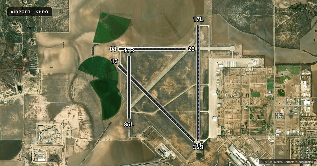
Runways & pattern
Full pagePattern entry · RWY 08
LEFT TRAFFIC| Runway | Heading (°M) | Length | Surface | Traffic |
|---|---|---|---|---|
| 17L/35R | 172° / 352° | 6,002 ft | CONC | 35R R |
| 13/31 | 127° / 307° | 5,545 ft | CONC | 13 R |
| 08/26Favored | 82° / 262° | 3,451 ft | CONC | Standard L |
| 17R/35L | 172° / 352° | 3,224 ft | ASPH | 17R R |
Runway end performance
| End | TORA | TODA | ASDA | LDA | VGSI | Approach lights | Obstruction |
|---|---|---|---|---|---|---|---|
| 17L | — | — | — | — | PAPI 4-box left(3°) | — | 98', bldg, 2450' from thr, 445' R of cntrln, slope 22 |
| 35R | — | — | — | — | PAPI 4-box left(3°) | — | — |
Declared distances in feet. TORA = takeoff run available, TODA = takeoff distance, ASDA = accelerate-stop, LDA = landing distance.
Airport sketch
Runways drawn to scale from FAA survey coordinates, rendered over satellite imagery. Not for navigation.
Approaches & charts
Services on the field
Fuel grades, oxygen, maintenance, ramp storage and lighting — as declared to the FAA by the airport operator.
Fuel & services
- Fuel
- 100LLA
- Airframe repair
- Major
- Power plant repair
- Major
- Other services
- AVNCS,INSTR,SALES
Ramp & ground
- Transient storage
- Tie-down
- Hangar
- Landing fee
- No fee published
- Customs
- Not available
- Lighting schedule
- SS-SR
- Beacon schedule
- SS-SR
- Beacon
- White / Green (civil land)(WG)
- Wind indicator
- Lighted
- Segmented circle
- Yes
Fuel & FBOs
Cheapest 100LL and Jet A on the field and nearby. Always confirm with the FBO before taxi.
Airport notes
Surface conditions, obstructions, local procedures, lighting outages and other notes published with each FAA cycle.
General notes
- DEER ON & INVOF ARPT.
- FOR CD CTC HOUSTON ARTCC AT 281-230-5622.
Fuel notes
- 100LLFUEL 24 HR SELF SERVE. FULL SERVE JET A & AVGAS ON REQUEST, 830-426-3810. 2 HR PRIOR NOTICE, AFT HRS.
Runway surface & condition
- 17R/35LCLSD TO ACFT OVER 12500 LBS.
- 08/26RWY WID IS 75 FT AND UNMKD; OVERALL PAVEMENT WID IS 150 FT.
Approach & departure obstructions
- 17LGRAIN BIN TWR.
Other notes
- BRING OWN ROPES FOR TIE DOWN.
VFR map & nearby airports
VFR sectional. Tap any ICAO chip to open that airport.
Key facts · KHDO
Answer card- ICAO
- KHDO
- Name
- SOUTH TEXAS RGNL AT HONDO
- Location
- HONDO, TEXAS
- Elevation
- 930.1 ft MSL
- Traffic pattern altitude
- 1,730.1 ft MSL (800 AGL)
- Control tower
- Non-towered (use CTAF)
- Total runways
- 4
- Longest runway
- 17L/35R · 6,002 ft
- Published ILS approaches
- 0
- Published frequencies
- 2
- Magnetic variation
- 8°
- Current flight rules
- VFR
- Current wind
- 100° at 5 kt
- Favored runway now
- RWY 08
South Texas Rgnl at Hondo sits in Hondo, Texas. Field elevation is 930.1 ft MSL. The airport has four runways. The longest is runway 17L/35R at 6,002 ft. This is an uncontrolled field. CTAF and UNICOM are both 122.725. No ILS approaches are published here.
Pattern altitude is 800 ft AGL, which is 1,730.1 ft MSL. Runway 13/31 is 5,545 ft concrete. Runway 08/26 is 3,451 ft concrete. Runway 17R/35L is 3,224 ft asphalt. Runway 17R/35L is closed to aircraft over 12,500 pounds. Runway 08/26 is unmarked. The pavement width there is 150 feet overall. There is also a grain bin tower near runway 17L, so keep that in mind on approach and departure.
South Texas Regional Airport at Hondo is on the field. It carries 100LL and Jet A Prist. Fuel is 24-hour self-serve for 100LL. Full service Jet A and Avgas are available on request with two-hour prior notice after hours. Bring your own ropes for tie down. Deer are reported on and near the airport. For clearance delivery, contact Houston ARTCC at 281-230-5622. If you are planning a first visit, review the current Chart Supplement before you go. That is the best place to confirm any current operational notes or changes.