METAR & TAF 8T8
8T8 does not publish a METAR.
Showing the nearest reporting station: KCVB (CASTROVILLE MUNI) · 10.4 NM away. Conditions at 8T8 may differ.
METAR · KCVB
Observed 12:35Z
KCVB 271235Z AUTO 09004KT 9SM CLR 24/23 A2998 RMK AO2
- Wind
- 090° @ 4 kt
- Visibility
- 9 SM
- Temp / Dew
- 24°C / 23°C
- Altimeter
- 29.98 inHg
- Clouds
- CLR
- Density alt
- 2,295 ft
- Ceiling
- Unlimited
- Rules
- VFR
Airport info & contacts
Manager on record, flight service, ARTCC, attendance schedule and pattern altitude — published by the FAA and refreshed every 28 days.
Location
- From city
- 10 NM W
- VFR sectional
- SAN ANTONIO
- ARTCC
- ZHU · HOUSTON
- NOTAM facility
- SJT (NOTAM-D)
Airport manager
- Name
- RONALD O'DEA
- Phone
- 210-488-5088
- Address
- 15464 CULEBRA RD BOX 14, SAN ANTONIO TX 78253
Flight service · Hours
- FSS SJT
- SAN ANGELO1-800-WX-BRIEF
- Attendance
- Unattended
Frequencies
Tap any row to copy the frequency to your clipboard.
Runways & pattern
Full pagePattern entry · RWY 17
LEFT TRAFFICRunway end performance
| End | TORA | TODA | ASDA | LDA | VGSI | Approach lights | Obstruction |
|---|---|---|---|---|---|---|---|
| 17 | — | — | — | — | — | — | 20', trees, 201' from thr, 100' R of cntrln, slope 0 |
| 35 | — | — | — | — | — | — | 25', trees, 201' from thr, 92' R of cntrln, slope 0 |
Declared distances in feet. TORA = takeoff run available, TODA = takeoff distance, ASDA = accelerate-stop, LDA = landing distance.
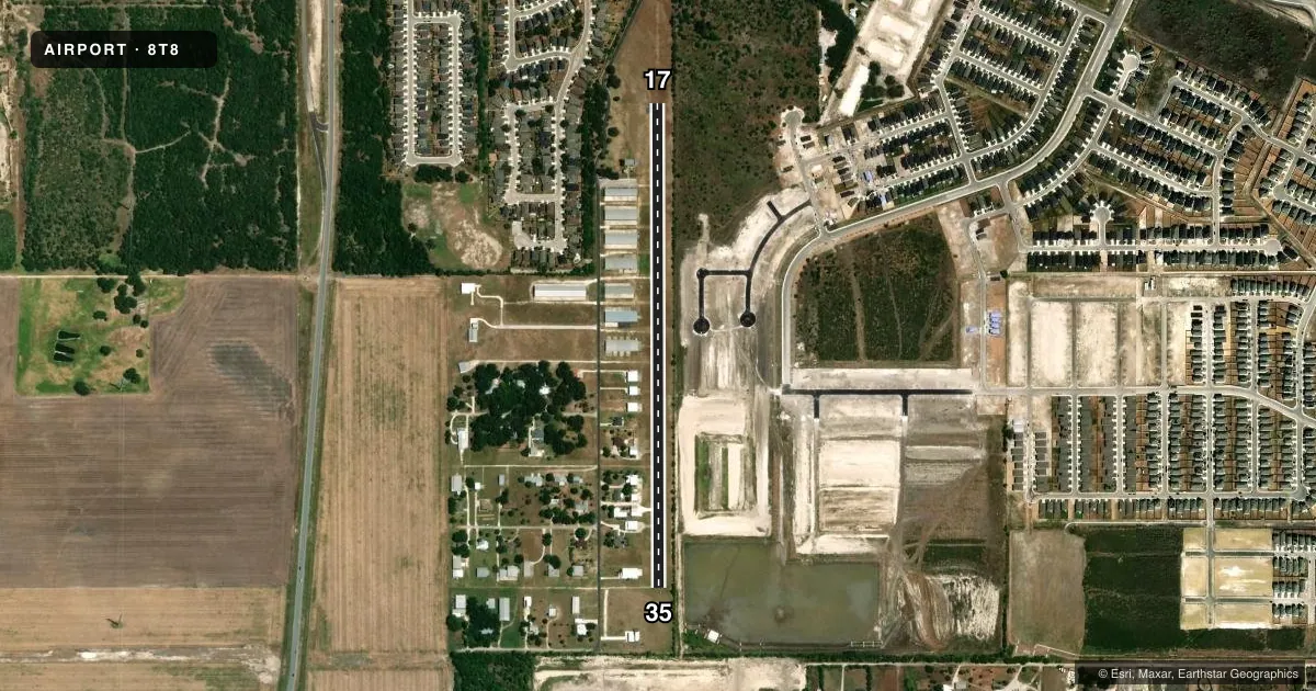
Airport sketch
Runways drawn to scale from FAA survey coordinates, rendered over satellite imagery. Not for navigation.
Approaches & charts
Services on the field
Fuel grades, oxygen, maintenance, ramp storage and lighting — as declared to the FAA by the airport operator.
Fuel & services
- Fuel
- Not available
Ramp & ground
- Transient storage
- Not published
- Landing fee
- No fee published
- Wind indicator
- Yes
- Segmented circle
- No
Fuel & FBOs
Cheapest 100LL and Jet A on the field and nearby. Always confirm with the FBO before taxi.
Airport notes
Surface conditions, obstructions, local procedures, lighting outages and other notes published with each FAA cycle.
General notes
- 15 FT HGRS 112 FT WEST ALONG RWY.
- LIMIT 3 TGLS DURG DAYTIME.
- FOR CD CTC SAN ANTONIO APCH AT 210-805-5516.
- POWERED PARACHUTES PROHIBITED.
- WILDLIFE ON & INVOF ARPT.
Runway surface & condition
- 17/35SHOULDERS SOFT & MUDDY WHEN WET.
Approach & departure obstructions
- 1722 FT TREES 100 FT EAST OF CNTRLN FULL LENGTH OF RWY.
- 3522 FT TREES 100 FT EAST OF CNTRLN FULL LENGTH OF RWY.
VFR map & nearby airports
VFR sectional. Tap any ICAO chip to open that airport.
Key facts · 8T8
Answer card- ICAO
- 8T8
- Name
- SAN GERONIMO AIRPARK
- Location
- SAN ANTONIO, TEXAS
- Elevation
- 1,040 ft MSL
- Traffic pattern altitude
- 2,040 ft MSL (1,000 AGL)
- Control tower
- Non-towered (use CTAF)
- Total runways
- 1
- Longest runway
- 17/35 · 3,000 ft
- Published ILS approaches
- 0
- Published frequencies
- 1
- Magnetic variation
- 7°
- Current flight rules
- VFR
- Current wind
- 090° at 4 kt
- Favored runway now
- RWY 17
San Geronimo Airpark (8T8) sits in San Antonio, Texas. Field elevation is 1,040 ft MSL. The airport has one runway. Runway 17/35 is 3,000 ft asphalt. There is no control tower. CTAF is 122.9. No ILS approaches are published.
Pattern altitude is not published. Use the current FAA Chart Supplement before flying, especially since the field elevation is 1,040 ft MSL. That puts the pattern at 2,040 ft MSL based on the field elevation. Verify before you fly. The published remarks matter here. There are 22-foot trees 100 feet east of the centerline along the full length of both runway directions. There are also 15-foot hangars 112 feet west of the runway. Wildlife is reported on and near the airport. Runway shoulders are soft and muddy when wet.
There are no on-field FBOs listed in the facts. Contact the airport operator directly before arrival, or call the field on CTAF for current FBO availability. For clearance delivery, contact San Antonio Approach at 210-805-5516. The airport also limits daytime touch-and-go landings to three. Powered parachutes are prohibited. This is a field where a first-time pilot should brief the runway environment, watch the tree line and plan for soft shoulders after rain.