METAR & TAF KSSF
Current METAR
Observed 13:33Z
KSSF 271333Z 17003KT 10SM OVC009 25/23 A2997 RMK AO2 CIG 008V014 T02500233 PNO $
- Wind
- 170° @ 3 kt
- Visibility
- 10 SM
- Temp / Dew
- 25°C / 23°C
- Altimeter
- 29.97 inHg
- Clouds
- OVC
- Density alt
- 1,854 ft
- Ceiling
- 900 ft AGL
- Rules
- IFR
Airport info & contacts
Manager on record, flight service, ARTCC, attendance schedule and pattern altitude — published by the FAA and refreshed every 28 days.
Location
- From city
- 6 NM S
- VFR sectional
- SAN ANTONIO
- ARTCC
- ZHU · HOUSTON
- NOTAM facility
- SSF (NOTAM-D)
Airport manager
- Name
- JEFFREY TRIPP
- Phone
- 210-207-1800
- Address
- 8535 MISSION RD, SAN ANTONIO TX 78214
Flight service · Hours
- FSS SJT
- SAN ANGELO1-800-WX-BRIEF
- Attendance
- 0700-2000
Frequencies
Tap any row to copy the frequency to your clipboard.
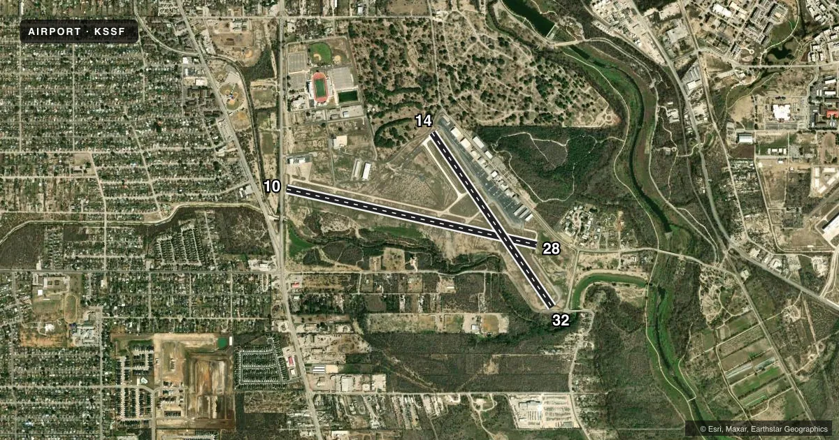
Runways & pattern
Full pagePattern entry · RWY 14
LEFT TRAFFIC| Runway | Heading (°M) | Length | Surface | Traffic |
|---|---|---|---|---|
| 10/28 | 100° / 280° | 5,000 ft | ASPH | Standard L |
| 14/32Favored | 142° / 322° | 4,128 ft | ASPH | Standard L |
Runway end performance
| End | TORA | TODA | ASDA | LDA | VGSI | Approach lights | Obstruction |
|---|---|---|---|---|---|---|---|
| 10 | 5,000' | 5,000' | 5,000' | 4,550' | PAPI 4-box left(3°) | — | 29', trees, 205' from thr, 25' R of cntrln, slope 0 |
| 28 | 5,000' | 5,000' | 4,677' | 4,677' | PAPI 4-box left(3°) | — | 25', trees, 730' from thr, 230' R of cntrln, slope 21 |
| 14 | 4,128' | 4,128' | 3,881' | 3,297' | PAPI 4-box right(3°) | — | 35', trees, 201' from thr, 0' R of cntrln, slope 0 |
| 32 | 4,128' | 4,128' | 3,902' | 3,530' | PAPI 4-box left(3°) | — | 25', trees, 201' from thr, 0' R of cntrln, slope 0 |
Declared distances in feet. TORA = takeoff run available, TODA = takeoff distance, ASDA = accelerate-stop, LDA = landing distance.
Airport sketch
Runways drawn to scale from FAA survey coordinates, rendered over satellite imagery. Not for navigation.
Approaches & charts
Services on the field
Fuel grades, oxygen, maintenance, ramp storage and lighting — as declared to the FAA by the airport operator.
Fuel & services
- Fuel
- 100LLA
- Oxygen (bottled)
- Not available
- Oxygen (bulk)
- Not available
- Airframe repair
- Major
- Power plant repair
- Major
- Other services
- CHTR,INSTR,RNTL,SALES
Ramp & ground
- Transient storage
- Tie-down
- Hangar
- Landing fee
- No fee published
- Customs
- Not available
- Lighting schedule
- SEE RMK
- Beacon schedule
- SS-SR
- Beacon
- White / Green (civil land)(WG)
- Wind indicator
- Lighted
- Segmented circle
- No
Fuel & FBOs
Cheapest 100LL and Jet A on the field and nearby. Always confirm with the FBO before taxi.
Airport notes
Surface conditions, obstructions, local procedures, lighting outages and other notes published with each FAA cycle.
General notes
- NUMEROUS ACFT OPERATING AT OR ABOVE 2500 FT MSL IN THE STINSON ARPT TFC AREA UNDER THE CTL OF SAN ANTONIO APCH.
- PAEW ADJ ALL TWYS & RAMP AREAS MON-FRI 0700-1759.
- FOR CD WHEN ATCT IS CLSD CTC SAT APCH AT 210-805-5516.
Lighting notes
- DUSK-DAWN. MIRL RWY 10/28 & 14/32 PRESET MED INTST WHEN ATCT CLSD.
Approach & departure obstructions
- 107 FT FENCE, 0 FT DSTC, 167 FT R; 15 FT RD O FT DSTC.
- 147 FT FENCE 21 FT DSTC. 14 FT RD, 35 FT DSTC ACRS APCH..
- 326 FT FENCE 0 FT DSTC;15 FT RD 20 FT DSTC, 120 FT L
- 10APCH SLOPE 25:1 TO DSPLCD THLD OVR 61 FT TREES, 1585 FT DSTC.
- 14APCH SLOPE 22:1 TO DSPLCD THLD OVR 50 FT TREES, 1100 FT DSTC.
- 32APCH SLOPE 24:1 TO DSPLCD THLD OVR 35 FT TREES, 835 FT DSTC.
VFR map & nearby airports
VFR sectional. Tap any ICAO chip to open that airport.
Key facts · KSSF
Answer card- ICAO
- KSSF
- Name
- STINSON MUNI
- Location
- SAN ANTONIO, TEXAS
- Elevation
- 577.6 ft MSL
- Traffic pattern altitude
- 1,577.6 ft MSL (1,000 AGL)
- Control tower
- Towered · 0700-2200
- Total runways
- 2
- Longest runway
- 10/28 · 5,000 ft
- Published ILS approaches
- 0
- Published frequencies
- 12
- Magnetic variation
- 3°
- Current flight rules
- IFR
- Current wind
- 170° at 3 kt
- Favored runway now
- RWY 14
Stinson Muni sits in San Antonio, Texas. Field elevation is 577.6 ft MSL. The airport has two asphalt runways. The longest is 5,000 ft on 10/28. Tower service is published from 0700 to 2200. No ILS approaches are published here, so plan with the current Chart Supplement and your approach setup in mind.
Pattern altitude is not published. Use 1,000 ft AGL for light piston traffic unless ATC or the current Chart Supplement says otherwise. The field sees a lot of traffic in the San Antonio approach area. Expect coordination with San Antonio Approach, especially when the tower is closed. Published remarks also note that medium intensity runway lights for 10/28 and 14/32 are preset from dusk to dawn when the tower is closed.
GateOne is on the field. It carries 100LL, Jet A and Jet A Prist. If you need clearance delivery after tower hours, the published remark gives San Antonio Approach at 210-805-5516. There are also published obstacle notes on the approach ends, including fences, roads and trees near both runways. Treat the departure and arrival paths with care. This is a busy controlled field in a metro area. Stay sharp on taxi instructions, runway assignment and local traffic flow.