METAR & TAF KBAZ
Current METAR
Observed 12:51Z
KBAZ 271251Z 18003KT 8SM CLR 24/23 A2997 RMK AO2 SLP140 T02440233
- Wind
- 180° @ 3 kt
- Visibility
- 8 SM
- Temp / Dew
- 24°C / 23°C
- Altimeter
- 29.97 inHg
- Clouds
- CLR
- Density alt
- 1,834 ft
- Ceiling
- Unlimited
- Rules
- VFR
Airport info & contacts
Manager on record, flight service, ARTCC, attendance schedule and pattern altitude — published by the FAA and refreshed every 28 days.
Location
- From city
- 4 NM E
- VFR sectional
- SAN ANTONIO
- ARTCC
- ZHU · HOUSTON
- NOTAM facility
- BAZ (NOTAM-D)
Airport manager
- Name
- ROBERT LEE
- Phone
- 830-221-4290
- Address
- 2333 FM 758, NEW BRAUNFELS TX 78130
Flight service · Hours
- FSS SJT
- SAN ANGELO1-800-WX-BRIEF
- Attendance
- 0700-1900
Frequencies
Tap any row to copy the frequency to your clipboard.
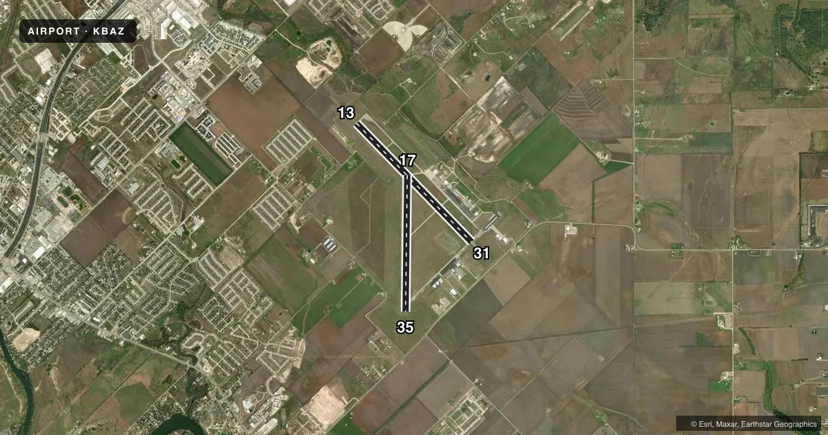
Runways & pattern
Full pagePattern entry · RWY 17
LEFT TRAFFIC| Runway | Heading (°M) | Length | Surface | Traffic |
|---|---|---|---|---|
| 13/31 | 128° / 308° | 6,503 ft | ASPH | Standard L |
| 17/35Favored | 173° / 353° | 5,364 ft | ASPH | Standard L |
Runway end performance
| End | TORA | TODA | ASDA | LDA | VGSI | Approach lights | Obstruction |
|---|---|---|---|---|---|---|---|
| 13 | — | — | — | — | PAPI 4-box left(3°) | MALS | — |
| 31 | — | — | — | — | PAPI 4-box left(3°) | — | — |
| 35 | — | — | — | — | — | — | 45', pline, 1300' from thr, 388' R of cntrln, slope 24 |
Declared distances in feet. TORA = takeoff run available, TODA = takeoff distance, ASDA = accelerate-stop, LDA = landing distance.
Airport sketch
Runways drawn to scale from FAA survey coordinates, rendered over satellite imagery. Not for navigation.
Approaches & charts
Services on the field
Fuel grades, oxygen, maintenance, ramp storage and lighting — as declared to the FAA by the airport operator.
Fuel & services
- Fuel
- 100LLA+
- Airframe repair
- Major
- Power plant repair
- Major
- Other services
- CHTR,INSTR,RNTL
Ramp & ground
- Transient storage
- Tie-down
- Hangar
- Landing fee
- No fee published
- Customs
- Not available
- Lighting schedule
- SEE RMK
- Beacon schedule
- SS-SR
- Beacon
- White / Green (civil land)(WG)
- Wind indicator
- Lighted
- Segmented circle
- Yes
Fuel & FBOs
Cheapest 100LL and Jet A on the field and nearby. Always confirm with the FBO before taxi.
Airport notes
Surface conditions, obstructions, local procedures, lighting outages and other notes published with each FAA cycle.
General notes
- BIRDS INVOF ARPT.
- HIGH PER MIL ACFT OPRG AT RANDOLPH AFB AUX FLD (SEGUIN-SEQ).
- FOR CD WHEN ATCT IS CLSD CTC SAT APCH AT 210-805-5516.
Lighting notes
- ACTVT MIRL RWY 13/31, RWY 17/35 - CTAF.
Fuel notes
- 100LLFUEL 24 HR SELF SVC. FOR FULL SERVE FUEL CALL 830-221-4290; AFT HRS CALL 830-221-4100. CALL-IN FEE.
Approach & departure obstructions
- 17APCH RATIO 50:1 AT DSPLCD THR.
Other notes
- EXISTED PRIOR TO 1959.
VFR map & nearby airports
VFR sectional. Tap any ICAO chip to open that airport.
Key facts · KBAZ
Answer card- ICAO
- KBAZ
- Name
- NEW BRAUNFELS NTL
- Location
- NEW BRAUNFELS, TEXAS
- Elevation
- 658.4 ft MSL
- Traffic pattern altitude
- 1,658.4 ft MSL (1,000 AGL)
- Control tower
- Towered · 0700-1900
- Total runways
- 2
- Longest runway
- 13/31 · 6,503 ft
- Published ILS approaches
- 0
- Published frequencies
- 12
- Magnetic variation
- 8°
- Current flight rules
- VFR
- Current wind
- 180° at 3 kt
- Favored runway now
- RWY 17
KBAZ is in New Braunfels, Texas. Field elevation is 658.4 ft MSL. The airport has two asphalt runways. The longest is 13/31 at 6,503 ft. Tower service is published from 0700 to 1900. No ILS approaches are published here, so plan with that in mind if the weather is marginal.
The published pattern altitude is not listed, so use the standard 1,000 ft AGL for light piston operations unless the current FAA Chart Supplement says otherwise. That puts the traffic pattern at about 1,658 ft MSL based on the field elevation. The airport is close to the San Antonio area, so expect busy training and transient traffic. Birds are reported in the vicinity. There is also a published note about a 50 to 1 approach ratio at the displaced threshold of runway 17, so pay attention on short final.
New Braunfels National Airport is the on-field FBO. It carries 100LL and Jet A. 100LL is available 24 hours self-service. Call the FBO directly for full-service fuel or after-hours help. Runway lights on 13/31 and 17/35 are activated by CTAF. If the tower is closed, clearance delivery goes through San Antonio Approach. Check current procedures before departure.