METAR & TAF 50R
50R does not publish a METAR.
Showing the nearest reporting station: KHYI (SAN MARCOS RGNL) · 10.2 NM away. Conditions at 50R may differ.
METAR · KHYI
Observed 12:10Z
KHYI 271210Z 15004KT 1SM HZ VV002 23/22 A2999 RMK AO2
- Wind
- 150° @ 4 kt
- Visibility
- 1 SM
- Temp / Dew
- 23°C / 22°C
- Altimeter
- 29.99 inHg
- Clouds
- VV
- Density alt
- 1,532 ft
- Ceiling
- 200 ft AGL
- Rules
- LIFR
Airport info & contacts
Manager on record, flight service, ARTCC, attendance schedule and pattern altitude — published by the FAA and refreshed every 28 days.
Location
- From city
- 2 NM S
- VFR sectional
- SAN ANTONIO
- ARTCC
- ZHU · HOUSTON
- NOTAM facility
- SJT (NOTAM-D)
Airport manager
- Name
- SEAN KELLEY
- Phone
- 512-398-6452
- Address
- PO BOX 239, LOCKHART TX 78644
Flight service · Hours
- FSS SJT
- SAN ANGELO1-800-WX-BRIEF
- Attendance
- 0800-1700
Frequencies
Tap any row to copy the frequency to your clipboard.
Runways & pattern
Full pagePattern entry · RWY 18
LEFT TRAFFICRunway end performance
| End | TORA | TODA | ASDA | LDA | VGSI | Approach lights | Obstruction |
|---|---|---|---|---|---|---|---|
| 18 | — | — | — | — | PAPI 2-box left(3.5°) | — | 12', tree, 355' from thr, 220' R of cntrln, slope 12 |
| 36 | — | — | — | — | PAPI 2-box left(3°) | — | 21', tree, 228' from thr, 80' R of cntrln, slope 1 |
Declared distances in feet. TORA = takeoff run available, TODA = takeoff distance, ASDA = accelerate-stop, LDA = landing distance.
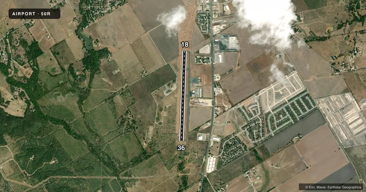
Airport sketch
Runways drawn to scale from FAA survey coordinates, rendered over satellite imagery. Not for navigation.
Approaches & charts
Services on the field
Fuel grades, oxygen, maintenance, ramp storage and lighting — as declared to the FAA by the airport operator.
Fuel & services
- Fuel
- 100LL
- Oxygen (bulk)
- Not available
- Airframe repair
- Major
- Power plant repair
- Major
- Other services
- INSTR,RNTL
Ramp & ground
- Transient storage
- Tie-down
- Hangar
- Landing fee
- No fee published
- Customs
- Not available
- Lighting schedule
- SEE RMK
- Beacon schedule
- SS-SR
- Beacon
- White / Green (civil land)(WG)
- Wind indicator
- Lighted
- Segmented circle
- Yes
Fuel & FBOs
Cheapest 100LL and Jet A on the field and nearby. Always confirm with the FBO before taxi.
Airport notes
Surface conditions, obstructions, local procedures, lighting outages and other notes published with each FAA cycle.
General notes
- WILDLIFE INVOF ARPT.
- FOR CD CTC AUSTIN APCH AT 512-369-7865.
Lighting notes
- DUSK-DAWN. MIRL RWY 18/36 PRESET LOW INTST; TO INCR INTST ACTVT - CTAF.
Approach & departure obstructions
- 3610 FT TREE, 3 FT DSTC 172 FT L.
Other notes
- THIS AIRPORT HAS BEEN SURVEYED BY THE NATIONAL GEODETIC SURVEY.
- PRE DATES THE ACT.
- MANAGERPUBLIC WORKS
VFR map & nearby airports
VFR sectional. Tap any ICAO chip to open that airport.
Key facts · 50R
Answer card- ICAO
- 50R
- Name
- LOCKHART MUNI
- Location
- LOCKHART, TEXAS
- Elevation
- 531.6 ft MSL
- Traffic pattern altitude
- 1,531.6 ft MSL (1,000 AGL)
- Control tower
- Non-towered (use CTAF)
- Total runways
- 1
- Longest runway
- 18/36 · 4,001 ft
- Published ILS approaches
- 0
- Published frequencies
- 4
- Magnetic variation
- 7°
- Current flight rules
- LIFR
- Current wind
- 150° at 4 kt
- Favored runway now
- RWY 18
Lockhart Muni is in Lockhart, Texas. Field elevation is 531.6 ft MSL. The airport has one runway, 18/36, which is 4,001 ft long. It is an untowered field, so plan your arrival and departure with standard CTAF discipline. Pattern altitude is not published. Use 1,000 ft AGL for light piston operations unless the current Chart Supplement says otherwise.
No ILS approaches are published here. CTAF and UNICOM are both 122.8. Austin Approach handles approach and departure services on 120.875 and 270.25. For clearance delivery, contact Austin Approach at 512-369-7865. The runway lights on 18/36 are medium intensity lights. From dusk to dawn they are preset to low intensity. Key the CTAF to increase intensity.
Martin & Martin Aviation is on the field. They carry 100LL. Wildlife has been reported in the vicinity of the airport, so build that into your taxi and runway scan. There is also a published obstruction near runway 36. A 10-foot tree sits 172 feet left of the runway centerline and 3 feet from the runway edge. First-time visitors should also keep the local terrain and density altitude in mind when planning summer operations in central Texas. Check the current FAA Chart Supplement for any updated remarks before flying in.