METAR & TAF 84R
84R does not publish a METAR.
Showing the nearest reporting station: KGYB (GIDDINGS-LEE COUNTY) · 12.9 NM away. Conditions at 84R may differ.
METAR · KGYB
Observed 10:35Z
KGYB 271035Z AUTO 00000KT 7SM SCT005 SCT010 24/23 A3001 RMK AO2 T02410234
- Wind
- 000° @ 0 kt
- Visibility
- 7 SM
- Temp / Dew
- 24°C / 23°C
- Altimeter
- 30.01 inHg
- Clouds
- SCT
- Density alt
- 1,369 ft
- Ceiling
- Unlimited
- Rules
- VFR
Airport info & contacts
Manager on record, flight service, ARTCC, attendance schedule and pattern altitude — published by the FAA and refreshed every 28 days.
Location
- From city
- 2 NM N
- VFR sectional
- SAN ANTONIO
- ARTCC
- ZHU · HOUSTON
- NOTAM facility
- SJT (NOTAM-D)
Airport manager
- Name
- MR. SANDY MEYERSON
- Phone
- 512-237-3282
- Address
- BOX 449, SMITHVILLE TX 78957
Flight service · Hours
- FSS SJT
- SAN ANGELO1-800-WX-BRIEF
- Attendance
- MON-SAT · 0900-1700
Frequencies
Tap any row to copy the frequency to your clipboard.
Runways & pattern
Full pagePattern entry · RWY 17
LEFT TRAFFICRunway end performance
| End | TORA | TODA | ASDA | LDA | VGSI | Approach lights | Obstruction |
|---|---|---|---|---|---|---|---|
| 17 | — | — | — | — | PAPI 2-box left(4°) | — | 106', trees, 2200' from thr, 30' R of cntrln, slope 18 |
| 35 | — | — | — | — | PAPI 2-box left(3°) | — | 45', pline, 1380' from thr, 680' R of cntrln, slope 26 |
Declared distances in feet. TORA = takeoff run available, TODA = takeoff distance, ASDA = accelerate-stop, LDA = landing distance.
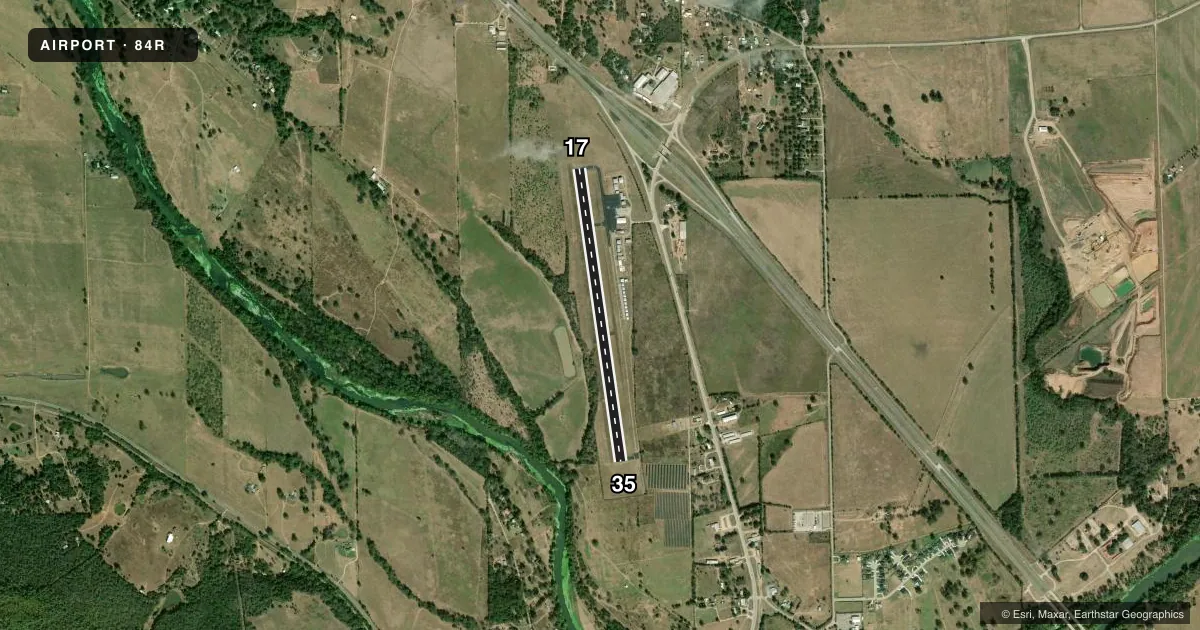
Airport sketch
Runways drawn to scale from FAA survey coordinates, rendered over satellite imagery. Not for navigation.
Approaches & charts
Services on the field
Fuel grades, oxygen, maintenance, ramp storage and lighting — as declared to the FAA by the airport operator.
Fuel & services
- Fuel
- 100LL
- Oxygen (bottled)
- Not available
- Oxygen (bulk)
- Not available
- Airframe repair
- Major
- Power plant repair
- Major
- Other services
- INSTR
Ramp & ground
- Transient storage
- Tie-down
- Hangar
- Landing fee
- No fee published
- Customs
- Not available
- Lighting schedule
- SEE RMK
- Beacon schedule
- SS-SR
- Beacon
- White / Green (civil land)(WG)
- Wind indicator
- Lighted
- Segmented circle
- Yes
Fuel & FBOs
Cheapest 100LL and Jet A on the field and nearby. Always confirm with the FBO before taxi.
Airport notes
Surface conditions, obstructions, local procedures, lighting outages and other notes published with each FAA cycle.
General notes
- WILDLIFE & LIVESTOCK INVOF ARPT.
- FOR CD CTC AUSTIN APCH AT 512-369-7865.
Lighting notes
- SS-SR ACTVT MIRL RWY 17/35 - 123.3.
Other notes
- 1AFTR HRS ATNDT 979-224-6304.
VFR map & nearby airports
VFR sectional. Tap any ICAO chip to open that airport.
Key facts · 84R
Answer card- ICAO
- 84R
- Name
- SMITHVILLE CRAWFORD MUNI
- Location
- SMITHVILLE, TEXAS
- Elevation
- 323.2 ft MSL
- Traffic pattern altitude
- 1,323.2 ft MSL (1,000 AGL)
- Control tower
- Non-towered (use CTAF)
- Total runways
- 1
- Longest runway
- 17/35 · 4,000 ft
- Published ILS approaches
- 0
- Published frequencies
- 3
- Magnetic variation
- 3°
- Current flight rules
- VFR
- Current wind
- 000° at 0 kt
- Favored runway now
- –
Smithville Crawford Muni sits in Smithville, Texas. Field elevation is 323.2 ft MSL. The airport has one runway. Runway 17/35 is 4,000 ft long with an asphalt surface. There is no control tower. No ILS approaches are published.
The pattern altitude is not published in the facts, so use the standard 1,000 ft AGL for light piston traffic unless the current FAA Chart Supplement says otherwise. CTAF is 122.9. Austin Approach and Departure frequencies are listed for clearance and radar services. For clearance delivery, contact Austin Approach at 512-369-7865.
The on-field FBO is Smithville Crawford Municipal Airport. It carries 100LL. Call (979) 242-3316 for current service details. Published remarks also note medium intensity runway lights on runway 17/35 from sunset to sunrise on 123.3. The PAPI operates continuously. Wildlife and livestock are in the area. There is also a marked and lighted 35-foot power line about 1,300 ft from the approach path. Keep that in mind on arrival. For a first visit, plan for a non-towered field with local traffic, nearby obstacles and Austin-area coordination if you need IFR services.