METAR & TAF T20
Current METAR
Observed 10:15Z
KT20 271015Z AUTO 00000KT 10SM CLR 25/25 A2999 RMK AO2 T02500245
- Wind
- 000° @ 0 kt
- Visibility
- 10 SM
- Temp / Dew
- 25°C / 25°C
- Altimeter
- 29.99 inHg
- Clouds
- CLR
- Density alt
- 1,552 ft
- Ceiling
- Unlimited
- Rules
- VFR
Airport info & contacts
Manager on record, flight service, ARTCC, attendance schedule and pattern altitude — published by the FAA and refreshed every 28 days.
Location
- From city
- 2 NM NW
- VFR sectional
- SAN ANTONIO
- ARTCC
- ZHU · HOUSTON
- NOTAM facility
- T20 (NOTAM-D)
Airport manager
- Name
- RALPH CAMARILLO
- Phone
- 830-672-2815
- Address
- 820 ST. JOSEPH ST, GONZALES TX 78629
Flight service · Hours
- FSS SJT
- SAN ANGELO1-800-WX-BRIEF
- Attendance
- Unattended
Frequencies
Tap any row to copy the frequency to your clipboard.
Runways & pattern
Full pagePattern entry · RWY 15
LEFT TRAFFICRunway end performance
| End | TORA | TODA | ASDA | LDA | VGSI | Approach lights | Obstruction |
|---|---|---|---|---|---|---|---|
| 15 | — | — | — | — | — | — | 15', trees, 388' from thr, 60' R of cntrln, slope 12 |
| 33 | — | — | — | — | — | — | 130', tower, 2600' from thr, 170' R of cntrln, slope 18 |
Declared distances in feet. TORA = takeoff run available, TODA = takeoff distance, ASDA = accelerate-stop, LDA = landing distance.
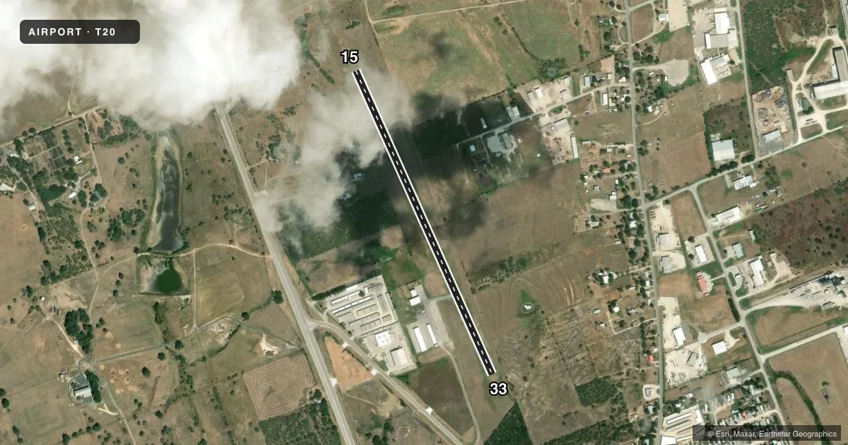
Airport sketch
Runways drawn to scale from FAA survey coordinates, rendered over satellite imagery. Not for navigation.
Approaches & charts
Services on the field
Fuel grades, oxygen, maintenance, ramp storage and lighting — as declared to the FAA by the airport operator.
Fuel & services
- Fuel
- 100LL
- Oxygen (bottled)
- Not available
- Oxygen (bulk)
- Not available
- Airframe repair
- Not available
- Power plant repair
- Not available
Ramp & ground
- Transient storage
- Tie-down
- Landing fee
- No fee published
- Customs
- Not available
- Lighting schedule
- SEE RMK
- Beacon schedule
- SS-SR
- Beacon
- White / Green (civil land)(WG)
- Wind indicator
- Lighted
- Segmented circle
- Yes
Fuel & FBOs
Cheapest 100LL and Jet A on the field and nearby. Always confirm with the FBO before taxi.
Airport notes
Surface conditions, obstructions, local procedures, lighting outages and other notes published with each FAA cycle.
General notes
- RWY 33 5 FT HILL, 80 FT R & L OF CNTRLN FROM THR NORTH 500 FT.
- FOR CD CTC AUSTIN APCH AT 512-369-7865.
- RWY 33, 100 FT ELEC TRANSMISSION LINE ACRS S APCH, 2400 FT DSTC, MKD & LGTD.
- NO LINE OF SIGHT BTN RWY ENDS.
Lighting notes
- MIRL RWY 15/33 PRESET ON LOW INTST; TO INCR INTST ACTVT - 123.0.
Fuel notes
- 100LLFUEL SELF-SERVE.
Approach & departure obstructions
- 1522 FT TREES 59-199 DSTC, 120 FT R; +4 FT FENCE 120 FT R AT THR.
- 334 FT FENCE AT THR, 122 FT R.
Other notes
- EXISTED PRIOR TO 1959.
- MANAGER830-263-2145 MGR CELL.
VFR map & nearby airports
VFR sectional. Tap any ICAO chip to open that airport.
Key facts · T20
Answer card- ICAO
- T20
- Name
- ROGER M DREYER MEML
- Location
- GONZALES, TEXAS
- Elevation
- 354 ft MSL
- Traffic pattern altitude
- 1,354 ft MSL (1,000 AGL)
- Control tower
- Non-towered (use CTAF)
- Total runways
- 1
- Longest runway
- 15/33 · 3,200 ft
- Published ILS approaches
- 0
- Published frequencies
- 1
- Magnetic variation
- 7°
- Current flight rules
- VFR
- Current wind
- 000° at 0 kt
- Favored runway now
- –
Roger M Dreyer Meml Airport (T20) is in Gonzales, Texas. The field elevation is 354 ft MSL. It has one runway, 15/33, which is 3,200 ft long and asphalt. There is no control tower. CTAF is 122.9.
No ILS approaches are published here. The pattern altitude is not published, so use the standard 1,000 ft AGL for light piston operations unless the current Chart Supplement says otherwise. The airport is a small non-towered field, so plan your self-announce calls and keep a close eye out in the pattern.
The on-field FBO is Roger M. Dreyer Memorial Airport. It carries AVGAS 100LL. Self-serve 100LL is available. The published remarks also note that runway 15 has trees and a fence near the threshold. Runway 33 has a fence near the threshold, a hill near the centerline north of the threshold and a marked and lighted transmission line on the south approach. Runway lights for 15/33 are preset on low intensity. Increase intensity by keying 123.0.
For clearance delivery, contact Austin Approach at 512-369-7865. First-time arrivals should pay close attention to the runway 33 approach environment and review current notes before departure.