METAR & TAF 34R
34R does not publish a METAR.
Showing the nearest reporting station: KVCT (VICTORIA RGNL) · 32.2 NM away. Conditions at 34R may differ.
METAR · KVCT
Observed 00:51Z
KVCT 270051Z 17012KT 10SM CLR 31/22 A2996 RMK AO2 SLP145 T03060222
- Wind
- 170° @ 12 kt
- Visibility
- 10 SM
- Temp / Dew
- 31°C / 22°C
- Altimeter
- 29.96 inHg
- Clouds
- CLR
- Density alt
- 2,215 ft
- Ceiling
- Unlimited
- Rules
- VFR
Airport info & contacts
Manager on record, flight service, ARTCC, attendance schedule and pattern altitude — published by the FAA and refreshed every 28 days.
Location
- From city
- 3 NM S
- VFR sectional
- HOUSTON
- ARTCC
- ZHU · HOUSTON
- NOTAM facility
- CXO (NOTAM-D)
Airport manager
- Name
- CLINT TAYLOR
- Phone
- 361-798-2201
- Address
- 101 N MAIN, HALLETTSVILLE TX 77964
Flight service · Hours
- FSS CXO
- MONTGOMERY COUNTY1-800-WX-BRIEF
- Attendance
- Unattended
Frequencies
Tap any row to copy the frequency to your clipboard.
Runways & pattern
Full pagePattern entry · RWY 17
LEFT TRAFFICRunway end performance
| End | TORA | TODA | ASDA | LDA | VGSI | Approach lights | Obstruction |
|---|---|---|---|---|---|---|---|
| 17 | — | — | — | — | — | — | 36', trees, 580' from thr, 156' R of cntrln, slope 10 |
| 35 | — | — | — | — | — | — | 25', trees, 380' from thr, 50' R of cntrln, slope 7 |
Declared distances in feet. TORA = takeoff run available, TODA = takeoff distance, ASDA = accelerate-stop, LDA = landing distance.
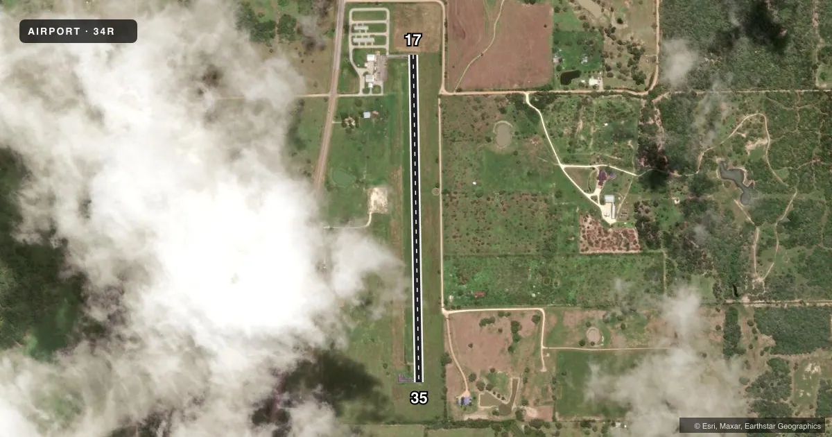
Airport sketch
Runways drawn to scale from FAA survey coordinates, rendered over satellite imagery. Not for navigation.
Approaches & charts
Services on the field
Fuel grades, oxygen, maintenance, ramp storage and lighting — as declared to the FAA by the airport operator.
Fuel & services
- Fuel
- 100LL
- Oxygen (bottled)
- Not available
- Oxygen (bulk)
- Not available
Ramp & ground
- Transient storage
- Tie-down
- Landing fee
- No fee published
- Customs
- Not available
- Lighting schedule
- SEE RMK
- Beacon schedule
- SS-SR
- Beacon
- White / Green (civil land)(WG)
- Wind indicator
- Lighted
- Segmented circle
- Yes
Fuel & FBOs
Cheapest 100LL and Jet A on the field and nearby. Always confirm with the FBO before taxi.
Airport notes
Surface conditions, obstructions, local procedures, lighting outages and other notes published with each FAA cycle.
General notes
- FOR CD CTC HOUSTON ARTCC AT 281-230-5622.
Lighting notes
- DUSK-DAWN. MIRL RWY 17/35 PRESET LOW INTST; TO INCR INTST ACTVT - CTAF.
Fuel notes
- 100LLFUEL 24 HR SELF SERVE.
Approach & departure obstructions
- 17RWY MKGS DISCOLORED.
- 35RWY MKGS DISCOLORED.
Other notes
- MANAGERDIRECTOR OF PUBLIC WORKS.
VFR map & nearby airports
VFR sectional. Tap any ICAO chip to open that airport.
Key facts · 34R
Answer card- ICAO
- 34R
- Name
- HALLETTSVILLE MUNI
- Location
- HALLETTSVILLE, TEXAS
- Elevation
- 277.7 ft MSL
- Traffic pattern altitude
- 1,277.7 ft MSL (1,000 AGL)
- Control tower
- Non-towered (use CTAF)
- Total runways
- 1
- Longest runway
- 17/35 · 3,210 ft
- Published ILS approaches
- 0
- Published frequencies
- 1
- Magnetic variation
- 7°
- Current flight rules
- VFR
- Current wind
- 170° at 12 kt
- Favored runway now
- RWY 17
Hallettsville Muni sits in Hallettsville, Texas. Field elevation is 277.7 ft MSL. The airport has one runway. Runway 17/35 is 3,210 ft long with asphalt surface. There is no control tower. CTAF is 122.9. No ILS approaches are published here.
Pattern altitude is not published. Use the standard 1,000 ft AGL pattern unless the current Chart Supplement says otherwise. The runway is lit with medium intensity lights. They are preset to low intensity from dusk to dawn. Use CTAF to increase intensity if needed. Runway markings on both ends are reported as discolored, so plan your visual scan accordingly.
Hallettsville Municipal Airport is the on-field FBO. It carries 100LL. Self-serve 100LL is available 24 hours. For clearance delivery, Houston ARTCC is the published contact. This is a small non-towered field, so expect self-announced traffic on CTAF and verify any local procedures before arrival. If you need current operational details, check the current FAA Chart Supplement or call the airport operator or FBO directly by phone.